This is the first post in a new blog section I’m calling Fun Finds. While most of my travel posts fall neatly into state high points or best state parks, this is where everything else goes—the unexpected stops, oddball places, and things you only notice when you slow down and take the back roads.
I’ve been hesitant to write this post. Not because I didn’t want to relive the experience—but because I’m not sure I fully recovered from it.
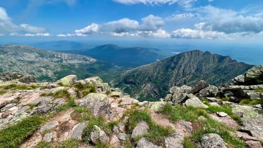
Climbing Mount Katahdin took more out of me—physically and emotionally—than any hike I had done up to that point. And yet, it gave me more in return.
The contrast alone was striking. Just days earlier, I had stood on Jerimoth Hill in Rhode Island, a gentle walk to a high point barely rising above the surrounding trees. Now I was staring up at Katahdin—the “Great Mountain”—rising to 5,268 feet above sea level, ranked #22 among U.S. state high points, and marking my 10th high point overall.
One of the State Parks that really surprised me was Liberty State Park | New Jersey. With the Manhattan skyline, Statue of Liberty and Ellis Island as a spectacular backdrop, Liberty State Park has got to be one of the state’s most dramatic parks. This 1212-acre State Park is one of newer State Parks – officially opening in 1976 to coincided with bicentennial celebrations. Much of the interior of the park is undergoing restoration due to hazardous material and severely contaminated land as much of the park is situated on landfilled tidal flats. But this shouldn’t be of concern and there is so much to enjoy at the park.
As many of you know, I am pretty passionate about making parks accessible to everyone, and Liberty State Park does not disappoint as there is no entrance fee. I parked at the Freedom Way parking lot and decided to visit the north end of the park first and then work my way south. Once past the parking lot and picnic area, you immediately see the dramatic Jersey City and Manhattan skylines.
Picture: Liberty State Park Map
Pictures: Jersey City skyline | Manhattan skyline with the North Cove in the foreground
The park has a rich history and you will find numerous monuments and memorials as you tour it. I first came across La Vela di Colombo, a two-story sail-shaped bronze monument designed by Gino Gianetti that commemorates the 500th anniversary of the westward journey of Christopher Columbus to America in 1492. The “Sail of Columbus” sits atop a stone base in the shape of a ship and features scenes of Columbus and his travels and was a gift from Government of Italy and the City of Genoa.
Picture: La Vela di Colombo
Next up – the historic Central Railroad of New Jersey Terminal (CRRNJ Train Terminal). From 1892 it was from this ferry/train station that two-thirds of all immigrants arriving at Ellis Island spread out across the US. And by the turn of the century, the CRRNJ Terminal accommodated between 30,000-50,000 commuters per day on 128 ferry runs and 300 trains. Still standing today are the Bush train sheds, housing 20 tracks and at the time the largest one ever built and the Communipaw Terminal, designed in a Richardsonian Romanesque style by architects Peabody & Stearns of Boston, Massachusetts and completed in 1889.
Picture: The Bush Train Sheds
Pictures: Historic Train | The Communipaw Terminal
As you come around the Bush Train Sheds, you are immediately struck by The ‘Empty Sky’ 9/11 Memorial. It’s the official State of New Jersey Memorial that honors the memory of the 750 people that lived in or had ties to New Jersey that lost their lives at the World Trade Center, the Pentagon, and Shanksville, PA on September 11, 2001
The names are placed randomly on the twin brushed stainless steel walls. Individuals’ names (4 inches tall) are within reach and engraved deep enough for hand rubbing. The memorial, designed by Jessica Jamroz and Frederic Schwartz, was dedicated on September 11, 2011, the 10-year anniversary.
The brushed stainless steel twin walls are 210 feet long, the width of each side of the World Trade Center Towers. They rise 30 feet, standing parallel to each other with a 12-foot wide paved path of bluestone between them. Like the World Trade Center, the stainless steel reflects the constantly changing light of day. The memorial invites visitors to literally and metaphorically look toward the empty sky in memory and look forward as a community.
Picture: The ‘Empty Sky’ 9/11 Memorial
Pictures: The ‘Empty Sky’ 9/11 Memorial
Picture: The ‘Empty Sky’ 9/11 Memorial
From the front of the CRRNJ Terminal, you can take a walk along the 2-mile Hudson River Waterfront Walkway. From the terminal you can also take a ferry to the Statue of Liberty and Ellis Island. As you walk along the waterfront, you will first pass Ellis Island then Liberty Island and the Statue of Liberty.
Picture: Ellis IslandPicture: Statue of Liberty and Liberty Island
At the southern end of the park is Black Tom Island and another monument – the Liberation Monument which commemorates the Holocaust and the role of the United States in preserving freedom and rescuing the oppressed. The memorial depicts an American soldier carrying a Jewish concentration camp survivor.
Pictures: The Liberation Monument
Picture: The Manhattan skyline with Ellis Island in the foreground
I finished up my visit with a walk through the Green Ring and Crescent Field. Liberty State Park is a great place for a run, to walk, to picnic and to enjoy spectacular views of the Manhattan skyline, Ellis Island and the Statue of Liberty. I would highly recommend a visit if you are in the area.
Blackwater Falls lives up to its hype as one of the most photographed and visited sites in West Virginia! It was, yet again, the perfect “storm” of events – I stayed on site at the Blackwater Falls State Park Lodge, the leaves were starting to turn color, the hikes were amazing, and the scenery breathtaking.
Picture: Sign in The Lodge
About the Park – Located in the Allegheny Mountains, Blackwater Falls State Park is named for the amber waters of Blackwater Falls, a 57-foot cascade tinted by the tannic acid of fallen hemlock and red spruce needles. The falls, along with a few of the park’s other features like Elakala Falls, Lindy Point and Pendleton Point Overlook, are some of the state’s most photographed spots. Visitors can enjoy the scenic views year-round by taking the steps to the falls, using viewing platforms or hiking the 20 miles of trails the park has to offer.
Picture: Trail Maps and Sites
The Lodge was nice, comfortable and clean – it was originally built in the 1950’s and since then has been renovated. There is a restaurant called the Smokehouse – and as you can guess – heavy on meat, but even this pescatarian was able to navigate the menu. However, it was unfortunate that they were understaffed for the volume of people and the restaurant itself needs a makeover. The space is also very awkward and cavernous in my opinion.
Pictures: The Lodge | A King Room overlooking the Canyon
Pictures: Views from the back of The Lodge
The next day was dedicated to hiking. Elakala Trail was first hike – a modest 0.5 mile trail where you pass by Elakala Falls. The trail starts at the south end of Blackwater Lodge, bridges the upper section with a great view of Elakala Falls, continues along the canyon rim and ends at the main park road across from Balanced Rock Trail. And as a surprise to those who know me well, I did not check-in to win prizes. I must have been off my “challenge game” that day!
Pictures: The WV Waterfall Trail Challenge | Elakala Falls from the top
Picture: Elakala Falls
I continued on to Balanced Rock Trail – a 1-mile trail that is somehow marked as somewhat difficult to difficult by the park service – but I am not sure if I would go that far. The trail crosses Shay Trace and Red Spruce Riding trails, continues to Balanced Rock and ends near Cabin 13 and Park Forest Road. One of the things I learned about West Virginia is that the state flower is the Rhododendron and this was evident as I hiked Balanced Rock Trail – rhododendrons were everywhere. At the end of the trail there are a couple of surprise – a large Field of Cairns – if you build it, they will come – and of all things a pay phone. I guess because cell service is spotty, there’s an option to call home ET – provided you have exact change. Wow – two movie references back to back!
Pictures: Balanced Rock Trail
Picture: Balanced Rock
Pictures: The Field of Cairns
Picture: Phone home ET
From here, I took a short walk up Park Forest Road until it connected to Shay Trace Trail. If you go left on Shay Trace you will end up at the base of the sled run, and if you go right – which I did – you will end up back at The Lodge. Along this trail you’ll cross Shay Run – the stream that flows over Elakala Falls that will give you a real sense of the amber waters in the area. I finished this hike at The Lodge for a total distance for this hike 2.4-miles.
Picture: Shay Run
Next it was off to Lindy Point Overlook. I drove there from The Lodge and decided to stop by the Sled Run and Nordic Center. Although not much to see at the Sled Run and Nordic Center, it was cool to see both. Back in the car and up to the small parking lot at the Lindy Point trailhead. Lindy Point Trail is an easy 0.7 mile out-and-back trail that sits at 3,000 feet and ends up overlooking the Blackwater Canyon. It was a bit wet and muddy the day I was there, but well worth the drive and short hike as you can see by the spectacular views.
Pictures: Views from Lindy Point Overlook
Picture: Blackwater Canyon from Lindy Point Overlook
From Lindy Point, I drove back into the park past the Lodge to the parking area across from the maintenance area and the Gentle trailhead. Gentle Trail is a short – 0.25 mile out-and-back – paved path to an observation deck overlooking Blackwater Falls. You quickly realize why this park is so popular and why it is one of the most photographed places in West Virginia when you see the falls from the observation deck. You can also see the leaves had started to change and I can only imagine how amazingly beautiful this place would look in a couple more weeks when the leaves are in full color.
Pictures: The Gentle Trail | Blackwater Falls from the observation deck
Picture: Blackwater Falls
Next, I took a shirt drive across the canyon, over the Blackwater River – where the amber color is even more deep and intense – to the Trading Post parking lot.
Picture: The Blackwater River and its deep amber color
The Blackwater Falls Boardwalk Trail starts at the Trading Post parking area and leads to a stone patio and boardwalk more than 200 steps down to an observation deck beside Blackwater Falls. This is the main viewing area for the falls and you get a pretty awesome view of the falls. On the way back up, I stopped at the upper viewing area for another view of the falls, then took the trail to the left (not sure if it has a name) back up to the parking lot versus going up the stairs. The total distance for the loop is about 0.5 mile and you get a good aerobic workout on the way back up.
Picture: Blackwater Falls from the lower observation deckPicture: Blackwater Falls from the upper observation deck
My next stop was Pendleton Point Overlook. It’s a short drive from the Trading Post parking lot, but as I felt like I was jumping in and out of the car, I decided to hike there. So I crossed the Blackwater Falls Road and up Picnic Acres Road to the Spudder Track Trail. In the winter time this trail is part of the beginner loop for cross country skiers. The trail goes behind the vacation-style cottages and by a picnic shelter, before you get to another parking area for Pendleton Point. It wasn’t the most scenic trail and only about 0.5 mile, but I did see some deer along the way.
Pictures: Someone has an itch | She didn’t like the fact that I interrupted her scratching
Finally it was out to Pendleton Point – a short 0.2 mile out and back trail. From Pendleton Point you get another breathtaking view of the canyon and you can see the Lodge across the canyon.
Pictures: Blackwater Canyon from Pendleton Point
Picture: Blackwater Falls State Park Lodge from Pendleton Point
The end of the hike was a bit anti-climatic as I walked along Blackwater Falls Road back to the Trading Post parking lot – about 0.5 mile. Total distance for this hike, including going down to the observation decks was 2.25 miles. All in all – a great experience, an amazing park and I’d highly recommend a visit!
At 812 feet, Jerimoth Hill is the highest point in Rhode Island. It ranks #46 among all U.S. state high points and was my 9th on the journey to visit the high point of every state.
Located in Foster, Rhode Island, near the Connecticut border, Jerimoth Hill is about 30 minutes west of downtown Providence. Named after early settler Jerimoth Brown (1783–1830), it’s one of the most accessible high points in the country—and also one of the easiest to overlook if you’re not paying attention.
One of my favorite parks I have visited thus far is Natural Bridge State Park in Kentucky. I think alot had to do with it being the “perfect storm” of events – I stayed in the park at the Hemlock Lodge, there weren’t a ton of people there, I got up and went hiking early, and when I got to the Natural Bridge, I was the only person on the bridge! And seeing how popular this park is, I was lucky to have the solitude and serenity.
About the park: Tucked within the Daniel Boone National Forest, Natural Bridge State Park is a 2,300-acre park that features a magnificent, natural sandstone arch. The bridge spans an incredible 78 feet and reaches 65 feet high, towering over an area nicknamed, “Kentucky’s Land of Arches.” The park also highlights over 20 miles of hiking trails to famous Kentucky sights like Fat Man’s Squeeze, Balanced Rock, and Lover’s Leap.
My hike: My room overlooked the lake area, which intrigued me, so despite knowing that I was going to hike down hill and then back up to the lodge parking lot to the Original Trail – about a total of a 1/2 mile. I did it and I was happy as it gave me a chance to explore more of this beautiful park. At the parking lot, there were several signs about bears, and knowing I was hiking alone and that there were few people out hiking, I had a little trepidation, but went on. I have since better educated myself on bears and what to do and I also carry bear spray as a last resort.
From the parking lot, I continued up the Original Trail to the Natural Bridge. This is the steepest part of the trail with an elevation change of 420 ft. It is a beautiful hike through the forest surrounded by hemlock, tulip trees, white pines and thickets of rhododendron. And of course, I saw my favorite – mushrooms – and had to take a picture.
Pictures: Some of the rock formations on the Original Trail up to the Natural Bridge
Pictures: Mushrooms – the beauty of nature | The Original Trail
As you come to the top of the Original Trail, you come around a bend, and see the Natural Bridge for the first time. I was not prepared for how magnificent it was going to be and the closer I got to it, the more awe-inspiring it was. It always amazes me at the power of nature and what it can create. The trail continues up until you are right under the bridge. From under the bridge, there is a super – yes super – narrow walkway – next to the bridge – that takes you up to the top of the bridge.
Picture: My first glimpse of the Natural BridgePicture: The Original Trail as you come to the base of the Natural BridgePicture: Underneath the Natural BridgePicture: One of my favorite views of the Natural BridgePicture: And super cool in black and white
Pictures: More of the underside of the Natural Bridge
Pictures: The super narrow stairway up to the top of the Natural Bridge
The second WOW – being on top of the bridge. I wasn’t prepared for the magnificent views and to be on such a daunting structure – it was super cool. And I’ll be honest – with my slight fear of heights, it was a bit scary on top, but well worth it! It should be noted, and as you can see from the pictures, there are no guardrails up there – just some warning signs to be careful near the edge. There are stories of people being careless and falling off, so be careful on top. From the top of the Natural Bridge, you can see Lookout Point in the distance – where I am headed to next.
Pictures: My first view of the top of the Natural Bridge | The massive beauty of the bridge
Picture: The view from the top looking at Lookout Point
Pictures: The beautiful morning fog in the valley | Me on top of the world!
From the Natural Bridge I took the Laurel Ridge Trail (#9) – a hike along the rim of the cliffs, where you will eventually pass the Skylift – a chair lift taking people up to the top. The trail then winds out to Lookout Point – the sandstone cliff you could see from the Natural Bridge. From Lookout Point, you get more amazing views and you can look back at the Natural Bridge. There is quite a big drop off from the point, and again there are no guard rails, so be careful as you get near the edge. I took a moment and had breakfast on Lookout Point, taking in the beauty and enjoying the serenity nature has to offer.
Picture: The SkyliftPicture: Looking back at the Natural BridgePicture: Post breakfast selfie
The trail continues along the rim and it can be narrow at some points, with some step drop-offs. Next you will come to two, very steep, stairs – Devil’s Gulch and Needle’s Eye – both will take you down to Battleship Rock Trail (#3). However, I continued on the trail to Lover’s Leap – another overlook with breathtaking views of the canyon below.
Pictures: Views from Lover’s Leap
Lover’s Leap is a dead end, so after enjoying the views, I turnaround and headed back. I decided to go down Needle’s Eye – built in 1934 by the Civilian Conservation Corps – which is very steep – so I took my time going down. At the base of the stairs, you connect to Battleship Rock Trail (#3). I took the trail back towards the Natural Bridge and along the way you will pass Battleship Rock and other beautiful rock formations. And for the life of me, I am not sure why I don’t have a picture of Battleship Rock?
Pictures: Needle’s Eye
Pictures: The hike along Battleship Rock Trail
Back at the Natural Bridge, I connected to the Rock Garden Trail (#4) which winds around below the cliffs and eventually takes you back to the Hemlock Lodge. I am so happy I decided to take this trail as you pass by more spectacular rock formations.
Pictures: Rock formations along Rock Garden Trail
Pictures: More rock formations along Rock Garden Trail
I was glad that I started out my day early and that I did not check out as I was able to take a shower and change before check out time and before I hit the road again. The total distance for the hike was about 4 miles and took me about 2 hrs. as I stopped several times. I highly recommend a visit to Natural Bridge State Park in Kentucky!
Brown County State Park is by far the largest State Park in Indiana encompassing nearly 16,000 acres. It’s nicknamed the “Little Smokies” because of the area’s resemblance to the Great Smoky Mountains with rugged hills, ridges and fog-shrouded ravines. Sorry, I didn’t see the resemblance, but none-the-less it is a beautiful park. I also realized as I am writing this, that I should have done more research on the park and area as I missed out on a lot that both have to offer. The park is located near Nashville, Indiana – a picture postcard of a town and an artisan community with over 200 galleries. And from the park’s website – the top five things to do:
Climb the 90’ Fire Tower for a breath-taking view of the hills o’ Brown.
Didn’t do – and bummed as I have a slight fear of heights and always try to overcome this.
See the rare (and state-endangered) Yellowwood tree on Trail 5.
Missed Trail 5 so didn’t see this.
Visit the nature center to see the rare, state-endangered timber rattlesnake.
Missed this, and it would have been cool to see the rattlesnake.
Jump in the Water Park pool, newly constructed at Abe Martin Lodge.
Missed this too.
Watch a sunrise or sunset from a vista.
Since I was on a schedule, left before sunset.
Oh well, I guess I need to make another visit to the park to experience the top 5 things to do. I also didn’t know there was a 7-vista challenge, which I would have been all over as many of you know how competitive I am. (Funny, I just noticed as I was looking at the pictures of the West Lookout Tower, there is a sign on the frame noting this is vista #1 in the challenge – missed that entirely!) With all that said, I did enlist the help of AllTrails to find the best trails to hike. I started out on the HHC TRAIL, a moderate 3.6 mile trail, with an elevation gain of 482 feet, that extends east from west lookout, continues to near Hesitation Point, and then southwest to parking area at Ogle Lake and Trail 7, where I started my hike.
I first took the trail up to Hesitation Point, one of the most popular vistas in the park with its picturesque views. The trail then goes parallel to the road, which I never understand why trails go so close to the road as it seems counterintuitive to being in the outdoors hiking. But enough of my rant. The next vista is West Lookout Tower Vista. There is a two-story tower overlooking the valley and apparently is the perfect stop for a glorious Brown County sunset. It was fashioned after structures built for surveyors who were working in the area. Map makers lived in the upper level while horses and livestock were stabled below.
Pictures: The entrance to Brown County State Park near Nashville, Indiana
Pictures: Trail #8 trailhead | The trail up to Hesitation Point
Picture: View from Hesitation PointPicture: West Lookout Tower
Pictures: The lower area for horses | View of the valley from the tower
Picture: Picture Frame noting this is Vista #1 in the Seven Vista Challenge
From the West Lookout Tower it was back down to the parking lot. I enjoyed this portion of the trail – away from the road through a beautiful forest and along a ravine. Once back to the parking lot, I decided to go around the lake on Trail #7 – a 1.2 mile loop with a slight elevation gain of 36 feet. (the Indiana Department of Natural Resources marks this trail as moderate, not sure why because they also mark trail #8 as moderate?) Ogle Lake is a 17-acre lake for fishing and boating. It was a nice hike and gave me some additional miles for the day.
As I was hiking trail #8 and then trail #7, I noticed all these temporary markers and wondered what they were for. Well near the end of my hike, I ran into a volunteer and found out that they were setting up for a major trail race – Dances With Dirt | Gnaw Bone. They tout it as the world’s most difficult 10K and you should expect double your road time and triple your effort! Sounds like fun? (actually it does as I love trail running) They also have a 5K, 13.1M, 26.2M, 50K, and 50M – yes a 50-miler!
Pictures: Ogle Lake | The marshy area at the end of the lake
Pictures: The area around the lake can be wet and marshy, so there are bridges and stumps to navigate
Picture: ✅ Another Best State Park in the books!
Date of visit: 18 May 2023
And on my way up to Illinois and Starved Rock State Park, I rewarded myself with some soft serve ice cream from the Dairy Bar in Lizton, IN – just northwest of Indianapolis.
In the few years I lived in Ohio, I never made it to Hocking HIlls State Park despite my colleagues and friends raving about it and camping there. And after visiting the park, I can see why there was so much hype about it! It’s a gorgeous park with over 25-miles of hiking trails, spectacular rock formations, beautiful waterfalls and amazing recess caves. There is a ton to see and I would highly recommend you dedicate at least one full day to the park. The park is definitely very busy during peak times, but I found that the further into the park you hike, the less people you will come across. With that said, I would still recommend visiting during an off-peak time, so you can really enjoy the park’s beauty.
I took the Gorge Overlook Loop via the Buckeye Trail which is 6.3 miles with a modest elevation gain of 429 feet and it will take you at least 2 hrs. 15 minutes (more if you take your time at the different sights along the way). I also added an out-and-back to Whispering Cave which adds another 1.0 mile, has a pretty good elevation gain of 300 feet, and it was definitely worth the extra time (probably another 30-minutes). It should also be noted that many of the trails in the park are one way.
The first area to explore is the Old Man’s Cave area which is broken up into five principal sections – Upper Falls, Upper Gorge, Middle Falls, Lower Falls and Lower Gorge. Old Man’s Cave got its name from the hermit, Richard Rowe, who lived in the large recess cave of the gorge. His family moved to the Ohio River Valley around 1796 from the Cumberland Mountains of Tennessee to establish a trading post. Interesting note – Richard is actually buried beneath the ledge of the main recess cave and his two brothers are also buried in the same area.
Being so close to the parking lot, the Upper Falls area is one of the busiest parts of the park you will encounter.
Picture: Upper Falls
Next you’ll come across The Devil’s Bathtub – a unique, tiered waterfall between the Upper Falls and Old Man’s Cave. The tub is situated in a weak layer of Black Hand Sandstone and is constantly enlarged by the swirling action of Old Man’s Creek. Although the pool is rumored to extend deep into the depths of Hades, it’s only a few feet deep!
Picture: Devils Bathtub
Pictures: A couple of the incredible rock formations
As you make your way through the gorge, you will crisscross Old Man’s Creek. I found the new concrete Step Bridge pretty cool and fun to walk over. These steps are below the A-Frame Bridge that you’ll cross near the end of your hike.
Pictures: The New Step Bridge | Rock Formation
The area around Old Man’s Cave can be a bit confusing with the one way trails, entrances and exits. But I was able to navigate it, although I think I went out the entrance to get back to the main trail. I found the tunnel to get their uber cool and the cave to be jaw droppijng at how expansive and beautiful it was. The Middle Falls are right by the cave. From here I resumed my trek south to the lower falls.
Pictures: Middle Falls and Old Man’s Cave | Tunnel to the Old Man’s Cave
Pictures: Old Man’s Cave
Picture: Lower Falls
I found that once I got past the Lower Falls, the crowds thinned out a quite a bit. Not that it was super crowded the day I was there, but relative to the Old Man’s Cave area, the rest of the hike had minimal people. From the Lower Falls, you head south and you will continue to see amazing rock formations.
Pictures: More amazing rock formations
At the southern end of the park, you have a choice, you can head west on the Hemlock Bridge Trail to the Whispering Cave Trail or continue east on the Buckeye Trail. I decided to check out Whispering Cave and I am so happy I did. Out and back is a mile and there is a bit of an elevation gain on this trail. It should be noted that the Hemlock Bridge Trail is ONE WAY and takes you all the way back to the Visitor Center after Whispering Cave. So before you decide to do this side excursion, read my note below – it’s after the pictures of Whispering Cave. Once on the Hemlock Bridge Trail you will cross a small foot suspension bridge. I personally think elements like these really make hiking fun and unique.
Picture: Food Suspension Bridge
As you climb up towards Whispering Cave Trail you’ll pass some incredible Honeycomb Weathered Sandstone. There are many theories on what causes the honeycombs and currently it is considered to be polygenetic in origin; being the result of complex interaction of physical and chemical weathering processes, which include salt weathering and cyclic wetting and drying.
Picture: Honeycomb Weathered Sandstone
Eventually you will come to the Whispering Cave Trail – a short out-and-back trail to Whispering Cave.
Pictures: Entrance to Whispering Cave | View looking out of Whispering Cave | Inside Whispering Cave
So here is my note regarding taking the Hemlock Bridge Trail: Now, I realize this is wrong and I hopefully won’t get any hate mail for this, but as it was not too busy at the park and I passed people going in the wrong direction on the Hemlock Bridge Trail, I went back down the Hemlock Bridge Trail to the Buckeye Trail. I.e. I too went in the wrong direction on this short section (0.3 mile) of the Hemlock Bridge Trail. I was respectful and gave everyone going in the right direction, the right of way.
Along the southern section of the park, you will come across some amazing trees and see the magnificent gorge walls. Eventually you will reach Whispering Falls. Whispering Falls doesn’t consistently flow (as was the case when I was there) and is a narrow plume of water that shoots off the towering rock face into Queer Creek gorge below.
Pictures: One of the many trees growing on the rocks | The steep walls of the gorge
Pictures: Natural Tunnel formed by a giant block leaning against the cliff | More of the magnificent walls of the gorge
Picture: Whispering Falls (or not)
The trail along the southern portion of the park is spectacular and well worth the hike. There are small waterfalls and more amazing rock formations. Eventually you will reach Cedar Falls – another very popular spot as there is a parking lot nearby. Cedar Falls itself is the greatest waterfall in terms of volume in the Hocking region. Queer Creek tumbles over the face of the Blackhand sandstone displaying the awesome force of water power.
Pictures: Rock Formation | Small Waterfall
Pictures: More Rock Formations
Picture: Cedar Falls
From the base of the gorge, you proceed up a long flight of stairs and will see signs for the Suspension Bridge. It’s a cool bridge adorned with a decorative piece at the top – a representation of one of the park’s geological features known as “The Sphinx.” From here you will continue along a ridge – overlooking the gorge below – then up to Rose Lake.
Pictures: Suspension Bridge | Rose Lake
Going to Rose Lake is a little bit of a detour, but you don’t have a choice due to the valley and stream that runs from the lake to the cliff above Queer Gorge. Once you cross the Rose Lake Dam, you head back south to the rim of the gorge and follow it west, then eventually north back towards the Visitor Center. This part of the trail is wooded and has a vibe than the gorge below. One of my many finds were some mushrooms, not edible, but I am always fascinated by the beauty of mushrooms.
Picture: Mushrooms on the trail above the gorge
You finish up your hike crossing the A-Frame bridge with views of the gorge below. And for the life of me, I am not sure why I don’t have a picture of the bridge? I only have a picture from the bridge, looking down on the gorge below. Perhaps my phone battery was dying as I was tracking my entire hike on an app.
Date of visit: 13 September 2022
Picture: View of the Gorge below from the A-Frame bridge
Hoosier Hill stands at 1,257 feet above sea level and ranks #44 among U.S. state high points, just behind Campbell Hill in Ohio. This marked my eighth state high point, and thanks to their close proximity—and the lack of any real hiking—it’s easy to pair the two together in a single trip.
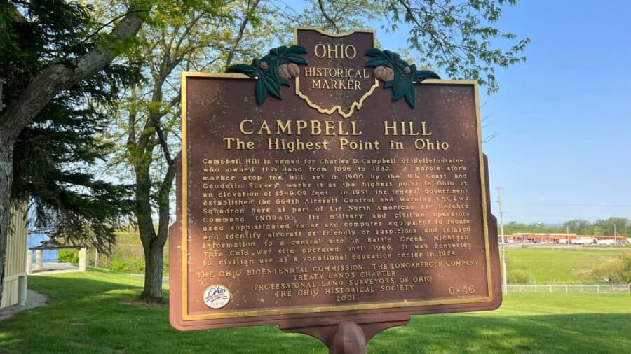
If you’re picturing a big hike or dramatic summit views, Campbell Hill will definitely surprise you. Ohio’s highest point—#7 on my state high-point journey—is tucked inside a career technical high school in Bellefontaine, about 50 miles northwest of Columbus. It’s low-key, easy to visit, and way more interesting than I expected.
At 1,549 feet above sea level, Campbell Hill ranks #43 among U.S. state high points, which explains why it feels more like a quick stop than a full-blown adventure. Park, walk a few steps, take a few photos, and you’re done.