
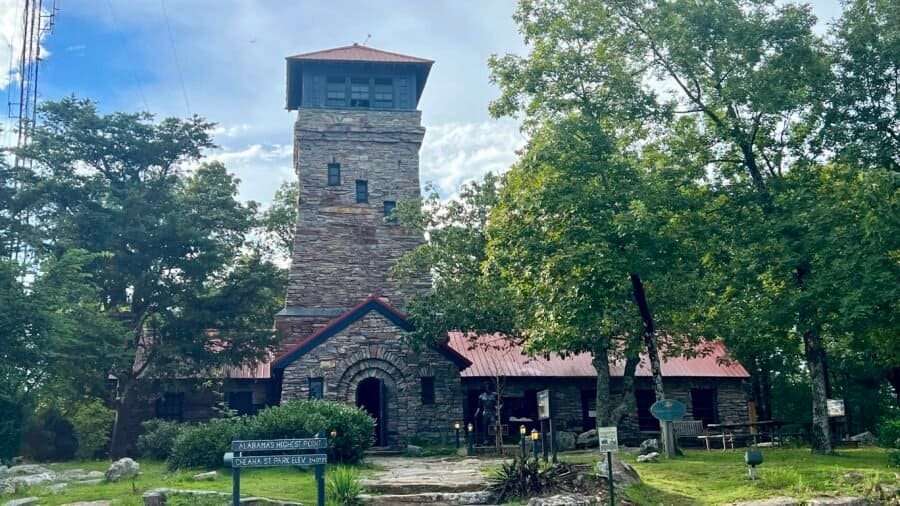
Cheaha Mountain—Alabama’s natural high point—was my 16th state high point, rising to 2,407 feet above sea leveland ranking #35 among U.S. State High Points. The summit is located within Cheaha State Park, the oldest state park in Alabama, and the southernmost extension of the Appalachian Mountain chain.
Month: November 2023
A little park history…
Located in the foothills of the Appalachian Mountains, Tishomingo State Park is steeped in history and scenic beauty. Archaeological excavations confirm the presence of Paleo Indians in the area now encompassed by the park as early as 7000 B.C.! The park takes its name from the leader of the Chickasaw nation, Chief Tishomingo. Today’s visitors to Tishomingo State Park discover the same timeless natural beauty that enchanted the Indians centuries ago. Tishomingo offers a unique landscape of massive rock formations and fern-filled crevices found nowhere else in Mississippi. Massive boulders blanketed in moss dot the hillsides, and colorful wildflowers border trails once walked by Native Americans.
Getting there…
The park is located 20-minutes south of Woodall Mountain – the highest natural point in Mississippi – which I blogged about recently. Here’s a link to that post Woodall Mountain Post. To get here, I drove on a portion of the famous Natchez Trace Parkway, the premier highway of the early 1800s and a modern scenic parkway, which runs directly through the park. I have more information on the Natchez Trace in my Woodall Mountain post.
Once you exit the Natchez Trace Parkway, you’ll get on State Park Road (Mississippi-90), then you’ll pass a park sign and then eventually a larger park monument sign, before you get to the entrance. The entrance fee is $2.00 per person, so pretty inexpensive as parks go. But free is best in my opinion.


Pictures: Park sign on Mississippi-90 | State Park Road/Mississippi-90 | Larger park monument sign
First Stop – The Office
It should come to no surprise for anyone who has followed this blog, my first stop was the office to chat with rangers about the park, to get a lay of the land, to find out which hikes were must-do’s and to find out what wildlife I should be aware of – Bears? Snakes? Big Foot? As it stands, I did see a bear near the office when I was about to start my first hike!


Pictures: My bear sighting! | Map of Tishomingo State Park Trails
I’m in for a hot, humid and buggy day!
The ranger recommended I start out with the Flat Rock Trail, which was right by the office. There is a small parking lot on the right of the entrance – where I parked. This trail is a 3-mile loop, but I opted shorten it at the suggestion of the ranger and just go to the campground and turn around – a 1.6-mile out and back hike. The trail starts out crossing a creek – which has a small wooden bridge. You’ll also see that State Park Road (the road you enter into the park) also has a bridge over the creek. The ranger suggested I go up and under the bridge, which I did – it was pretty cool!


Pictures: State Park Road Bridge | The start of the Flat Rock Trail | The Trailhead Area
The first half of the hike was the best part as you go by some really cool rock formations and boulders, and through some neat passageways. I can only imagine back in the day – would these passageways be safe or would I be easy prey for the Chickasaw? The rest of the trail is nice and you’re basically hiking through the woods. There are a couple of areas that are up and down, but nothing too difficult. The trail was 99% dry and there were a few bugs out, but the day was just starting and it was getting quite humid and hot. I found the trail well marked and outside of a couple of trees down, it was pretty clear and easy to navigate.


Pictures: Rock formations and boulders at the beginning of the hike


Pictures: One of the rock passageways | Rock formation


Pictures: One of the down trees | My turnaround point for the Flat Rock Trail. The trail comes in from the upper right corner of the picture.
Once back at the office, I drove further into the park and stopped by the Pioneer Cabin and Well House for a quick visit.


Pictures: Pioneer Cabin | Well House


Pictures: From the area near the Pioneer Cabin
I would have been part of the CCC…
I then drove down and parked near the park’s famous Swinging Bridge. It was constructed in 1939 by the Civilian Conservation Corps. The CCC was a voluntary government work relief program that ran from 1933 to 1942 in the United States for unemployed, unmarried men ages 18–25 who had difficulty finding jobs during the Great Depression in the United States. The program was a major part of President Franklin D. Roosevelt’s New Deal that supplied manual labor jobs related to the conservation and development of natural resources in rural lands owned by federal, state, and local governments. If I had lived back then, I probably would have been part of the CCC. After all, I have the right physique as I think my abs look like the one in the statue! lol.


Pictures: Statue and plaque commemorating the Civilian Conservation Corps Worker
Five Person Limit
Back to the Swinging Bridge which has a sign noting a “5 person limit.” Somehow, I think this rule has been violated a bit in the past – just saying. Since it was a quiet day, I was the only person on the bridge – and even with me on it solo – it did swing a bit. I can only imagine how much it moves when 5 people are on the bridge! The bridge spans Bear Creek – which was quite muddy and flowing at a good pace due to the recent rain. After you cross the creek, you’ll connect with the Outcroppings Trail – my next hike.


Pictures: The Swinging Bridge and 5-Person Limit Sign


Pictures: Swinging Bridge | Muddy Bear Creek

Rare Salamanders and Scorpions?
I decided to take the trail to the right and follow along Bear Creek. You meander along the river for 9/10 of a mile. It is an easy hike with some small ravines, lots of rocks and a small brook. At one point I came across really cool tree that over time grew at a bent angle. I love how mother nature and trees adapt to their surroundings and sometimes they don’t just grow up as straight trees – rebels that buck the system. As I hiked, I kept an eye out for two rare species of creatures that are found predominately in the park and Tishomingo County – Vaejovis carolinianus, commonly called the Southern Devil Scorpion or unstripped scorpion – and the state endangered Green Salamander (Aneides aeneus). The ranger at the office gave me the heads up about these creatures – yet another reason to stop by the office or visitor center.
Interestingly, at least to me, while scorpions frequently live in hot and dry areas, there are at least two scorpion species are at home in Mississippi’s often cold and wet climate – Vaejovis carolinianus, which I noted above and found only in northeast Mississippi where I am; and Centruroidis vittatus, known as the striped scorpion, found sporadically in central and southern parts of the state. Unfortunately, I didn’t come across any, I think you have to really search for them, in essence stop and pull up rocks to find such creatures. But I did see a frog! And according to Google Lens – I think it is a Pickerel Frog.


Pictures: Outcroppings Trail along muddy Bear Creek | Cool Bent Tree on the Trail
Magic Mushrooms?
I came across some cool mushrooms – one of my fascinations in nature – and this pool of water that had an iridescent hue to it. And no, I didn’t eat the mushrooms before I saw the water – so I wasn’t tripping out and hallucinating from eating the “magic mushrooms.”


Pictures: Mushrooms | Iridescent pool of water
The trail soon goes up and away from the creek. Personally, I think this is where the trail gets more interesting. You get a nice view of the valley below and will come across some neat boulders, rock formations and caves – I’m guessing at this point you’re learning about my fascination with rocks and boulders as well. I later found out that the Chickasaw Indians actually lived in these caves when they inhabited the area. I did see any in the caves, but I did see one on the roadside as I drove through the park.


Pictures: Boulders and rocks on the upper portion of the trail


Pictures: Caves and overhangs where the Chickasaw lived


Pictures: More rock formations | Looking down from the rocks above
A Full Day of Hiking
The trail loops back the Swinging Bridge – where I was parked. I got back into my car and was off for my next hike – the CCC Camp Trail. I drove back up to the Pioneer Cabin, and parked across the street, near the picnic area. I should note that I later realized I could have just kept my car at the Swinging Bridge as you’ll see as you read on, but I ended up being happy that I drove to this parking spot. It helped break up the day for me, it gave me an opportunity to have some water, a quick snack and to be in the comfort of my car’s air-conditioning, and it gave me time to figure out where the CCC Camp Trail started. This trail is a 3-mile loop that starts out generally flat, then drops down to the Swinging Bridge, then goes along Bear Creak and finally back uphill to the parking lot.
As I sat across the street and looked at the Pioneer House, I scanned the roadside and to far left of the Pioneer House, was a set of stairs – this is the CCC Camp Trailhead. So up the stairs I went on my last excursion in the park. Soon after you ascend the stairs, you’ll pass some more rock formations and boulders that are heavily covered in moss due to the shade.


Pictures: Moss covered rocks | CCC Camp Trail
Is that a UFO?
The trail follows the road for a bit – not my favorite – but you’re up high enough above the road and luckily there were only very few cars – so not alot of street noise. Otherwise it would have reminded me of Lincolnwood State Park in Rhode Island – which was not a favorite hike. You’ll eventually head down the hill, past the Swinging Bridge and through a parking lot. At the far end of the parking lot, the trail resumes and it’s at this point that you hike parallel to a Disc Golf Course – so keep a keep eye out for flying discs!


Pictures: The Disc Golf Course
Shortly after you pass the course, you’ll cross a bridge and then the trail got a bit dicey as there were alot of trees down in this section of the park. It wasn’t difficult to follow the trail, you just had to take a few detours around the downed trees. Before you head back up the hill, there is a directional sign – one of the few signs I saw on the trails. So up the hill I went to the Pioneer Cabin, past some more downed trees and back to the car.


Pictures: Bridge | Downed Trees | Directional Sign
On the way out of the park, I stopped by the glamping tent sites, courtesy of TENTRR. I have yet to stay at a TENTRR campsite, but do have the app on my phone. Tishomingo State Park is an interesting park with some cool rock formations and history. I’d definitely recommend a visit if you’re in the area, but it’s definitely not a destination state park like Ricketts Glen State Park. At least in my opinion.

Date of Visit: 13 August 2023
About Woodall Mountain — History 101
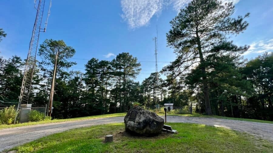
Woodall Mountain is the highest natural point in the U.S. state of Mississippi at 806 feet and ranks #47 in State High Points. It is located just off Mississippi Highway 25, south of Iuka in Tishomingo County in the northeast part of the state. I also happened to combine this trip with my visit to Tishomingo State Park (on my list of Best State Parks), which I will blog about at a later date.

At 4,145 feet above sea level, Black Mountain is the highest point in the Commonwealth of Kentucky, ranking #27 among U.S. state high points and sitting quietly along the Kentucky–Virginia border. This was my 14th state high point, and while the hike itself turned out to be fairly uneventful, the experience surrounding it was anything but.

Mount Rogers sits within the Mount Rogers National Recreation Area and rises to 5,729 feet above sea level, ranking #19 among U.S. state high points. It also marked my 11th summit on this high-pointing journey.
The Mount Rogers National Recreation Area is expansive, with four designated wilderness areas, more than 400 miles of trails, eleven campgrounds, and scenic drives like the Mount Rogers Scenic Byway and the road to Whitetop Mountain. It’s also home to 60 miles of the Appalachian Trail and 18 miles of the Virginia Creeper Trail. This corner of southwest Virginia is truly one of my favorite parts of the country.
At a Glance
At 409 feet, Point Reno is the highest point in the District of Columbia. It ranks #50 among U.S. state and district high points (with Florida at #51) and was my 12th overall.
It still feels a little funny checking off a “high point” in Washington, D.C.—especially coming on the heels of Mount Washington and Mount Katahdin—but it’s on the list, so off I went to the nation’s capital.
Franconia Notch State Park is located in the heart of the White Mountain National Forest and about 1 hour north of the state capital, Concord, NH. Franconia Notch is a spectacular mountain pass traversed by a unique parkway which extends from the Flume Gorge at the south to Echo Lake at the north. For eight miles, I-93 winds between the high peaks of the Kinsman and Franconia mountain ranges. The park offers a wide range of activities from swimming at Echo Lake to trout fishing at Profile Lake, to riding a bike on the Recreational Trail, to hiking the Appalachian Trail, to camping, and to riding the aerial tramway at Cannon Mountain.

A tale of two cities….
I decided to start my adventure visiting the famous Flume Gorge. Oh boy – where do I begin?! For starters there is a fee to visit this area – $18.00, plus a processing fee of $1.00! I understand the need to support parks, but I also have a disdain for high park fees, which limit park accessibility to those less fortunate and in my opinion these parks in essence become elitist. You also have to select a date and time for entry. This limits the number of people who are in the area at one time. Anyway, I paid my money and went in, your welcome State of New Hampshire. What I didn’t expect, were the amount of “city folk” in this section of the park, who honestly had a high disregard for the environment around them. More to come on this front.

The trail is a relatively easy 2-mile loop (one-way), with some inclines and stairs, but nothing too difficult. It is a well maintained trail (which I would expect for $19!). So, the first major site is the Great Boulder – it’s a big rock, but there is some history with it.


Pictures: History about the Glacial Boulders | The Great Boulder
Soon after the Great Boulder, the trail begins the one-way direction to the right. Shortly after this turn you’ll see one of the famous covered bridges that New Hampshire is known for, spanning the Pemigewasset River. (Say that 5-times fast!)


Pictures: Covered Bridge | Pemigewasset River
Next up, Table Rock. This is a super cool flat rock that would be awesome to ride down, only if you could!


Pictures: Table Rock
You’re not a model….
Next up the famous Flume Gorge – which I will admit was pretty cool. It was formed nearly 200 million years ago during the Jurassic Period and was discovered in 1808 by 93-year-old “Aunt” Jess Guernsey when she accidently came upon it while fishing. Pretty cool, but enter in the city folk – if I go to one more park and get behind girls who think they are one of the Jenners and decide it’s time for an Instagram photoshoot, I may go postal. And you know the pose they do – they look at the gorge and turn their head back to the camera as if they are a super model. News flash – nobody cares and you’re not!


Pictures: Flume Gorge (sans super models)
As you exit the narrow portion of the gorge, you come up Avalanche Falls. I did take an opportunity to take a selfie – but rest assured, no one waited as I took my picture. (And yes I do look like a super model – lol)


Pictures: Avalanche Falls | My quick selfie
Some cool parts of the “city” (Tale of Two Cities)…
As you continue on the loop, you’ll come across Bear Cave, then cross the Pemigewasset River again.


Pictures: Bear Cave | Pemigewasset River
It was around this point, where I came across the next group of “city folk” – it looked like a couple of families – who were loud, obnoxious and their kids were running everywhere. In reality, I can get past all of this, but there is more to come . . .
I took the short detour to Liberty Gorge – where you can see the gorge and the Pool. The pool is surrounded by 80-foot cliffs, is 150-feet in diameter and 40-feet deep. I bet it would be a great place to swim on a hot summers day!


Pictures: Liberty Gorge | The Pool
As the trail winds around the pool, you cross a covered foot bridge. I waited for the city folk to clear the bridge, which seemed like an eternity.


Pictures: Covered Foot Bridge
Please go back to the city…
The Wolf’s Den was next, which I don’t have pictures of, thanks in part to the city folk. One of the fathers – Mr. Macho in his white tank top and knee-length jean shorts, decided to crawl up through the crack in the rocks – ignoring signs about the fragile eco-system in the area. Way to set a good example for your kids, dude. His wife was half terrified and half amused. Me – I was just thinking – go back to the city.
As you finish the loop, there is view point where you can see Mount Liberty, Mount Flume and Mount Osseo. Then you’ll come across more glacial rocks. I loved the tree growing around one of the rocks.


Pictures: Mount Liberty, Mount Flume and Mount Osseo | Glacial Rocks
I finished up this hike in the visitor center, ate a little snack and headed to the Lonesome Lake Trail.
Lonesome Lake Trail
I drove to the trailhead, which is near the Lafayette Place Campground and has a parking lot. I enjoyed my hike along the Lonesome Lake Trail, but again, ran into some city folk. The trail is 3-miles up, around the lake and back. It has a pretty good elevation change of 1,030 feet, so be prepared for a good cardio workout at the beginning. As you start your hike, you cross the Pemigewasset River, yet again, but at this point it is a much smaller river. You then hike up through the campground, then being the ascent up the hill to Lonesome Lake (cardio workout portion). On your ascent, you will come across some streams that feed into the Pemigewasset River.


Pictures: Pemigewasset River | Stream feeding into the Pemigewasset River
As I hiked to the lake, I was a bit worried as I had read on the park website and there were also signs posted about a portion of the trail being closed around the lake due to flooding. But as I passed other hikers, I asked them where they had been and if any portion of the trail had been closed. I was happy to learn that there were no trail closures. Lonesome Lake is a beautiful lake and away from the noise of I-93, which was nice.


Pictures: Lonesome Lake | Another Selfie
Enter in the City Folk…
The area around the lake is swampy, and for the most part this is not an issue as there are raised “walkways” in the wetter areas. This is generally not an issue and easy to navigate, that is unless you have to pass someone. Hopefully they are polite and wait if you are already on the walkway, but with city folk, that wasn’t always the case. I had more than one standoff on the walkways, but found a way to allow them to pass.
Around the backside of the lake is a camp, and an area that is easy to access the lake and swim. There was a group of girls swimming and they looked like they were having fun. If I were better prepared, I probably would have gone swimming as well.


Pictures: Raised Walkway | Swimming Area
As I rounded the lake, near the area which I thought was closed, I ran into my next group of city folk. It was a group of younger adults with a dog – which I have no issue with – however their dog was a bit aggressive and not on a leash. Don’t get me wrong, I love taking my dog on a hike sans-leash, but when I would come upon other hikers, I would put her on a leash. It’s about being courteous to others – in my opinion. I was able to maneuver around the dog as they yelled at it to behave itself.
At this point, I headed back down the hill. On my way through the campground I did pass the bathroom and shower area. I decided to check it out and it was a pretty nice facility. Good to know if I am in the area again and want to camp.
Franconia Notch State Park, despite all the city folk, was a really nice park. Next time, I’d probably explore some of the less traveled trails – those with significant elevation changes and with more distance. (map below) And for those who haven’t visited yet, you need to determine if the steep fee for Flume Gorge is worth it.
Date of Visit: 14 July 2023

Lincoln Woods State Park is about a 15 minutes north of Providence, Rhode Island, and I would definitely classify it as an Everyday or People’s or City Folk Park (for more details on my classification – see my post on Starved Rock State Park). It is a popular getaway for northeastern Rhode Islanders and happens to be Rhode Island’s first state park.
About the Park (from their website)
Lincoln Woods State Reservation started officially on Abraham Lincoln’s birthday, February 12, 1909. Named after the 16th President of the United States, Lincoln Woods was acquired by purchase, gift, and condemnation of farmland and woodlots of the Olney, Arnold, Comstock, and Mitchell families of the Salyersville, Lonsdale, and Quinsnicket areas of Lincoln. Over the years since, Lincoln Woods has grown to 627 acres, which now rim the pond and include playing fields to the south. The facilities have grown and improved to include changing rooms for the swimmers, a snack bar, nature barn, and park administrative and maintenance facilities. With bridle and hiking trails throughout, the basic feature besides Olney Pond which also caters to fishing and boating including swimming, is a circumferential road favored by walkers and bicycle riders. In 1977, the swimming area was dedicated as the Frank Moody State Beach.

My Visit
At the Breakneck Hill entrance, a covered bridge greets parkgoers as they enter the park to enjoy swimming at the freshwater beach, trout fishing, playing ball, hiking, jogging, horseback riding, or just relaxing under a shade tree. There is no entrance fee for the park (if you have read any of my other posts, you know that I am supportive of no fee parks), but permits are required for picnic areas and fields.

I went on a Saturday in the summer and it was hot, humid and buggy. Definitely not my idea of a great park day – just saying. I hiked a combination of the Les Pawson Trail, which goes around Olney Pond, and the Lincoln Woods Trail which goes around the northern portion of the park, where many of the picnic areas and ball fields are located. In total I hiked 5.5 miles – parts of the trails were paved and other parts dirt – and as I mentioned in my All Trails review – the trails are poorly marked. With that said, it’s not as if you are really going to get lost very easily and we need to call out search and rescue.
First stop – Frank Moody State Beach
I parked near Olney Pond and Frank Moody State Beach was my first stop. It’s not the biggest beach and although somewhat crowded, there was still some open space on the beach. The beach was full of families, kids running around and lots of music playing. The beach area has a large concession stand, bath house, kayak rentals and a nature center. The nature center houses a myriad of live and taxidermized animals that represent the various species found in Lincoln Woods and across Rhode Island. I actually went in the nature center – as I always do – to learn more about the park and what to see. I think two young adults who worked there were thrilled to have someone walk in as they looked so bored. I also think they drew the short straw on assignments and would have probably been outside working. Honestly, I don’t think most of the people who go there, even care about the natural surroundings and what they may find in the park. The concession stand was a surprise as to the variety of food they offered. I didn’t try anything, but it looked good.


Pictures: Entrance to the Beach and Kayak Rental area


Pictures: Concession Stand


Pictures: Beach Area

Why is this an Everyday or People’s or City Folk Park?
So as I continued around the pond – the trail parallels the road and as it was a Saturday – it was crowded with cars and many blaring loud music. So don’t go here if you’re looking for solitude or some peace and quiet. And if you are hiking or walking on the trails or walkways – be prepared for oblivious people and let’s say kid’s that are not the most behaved.
Eventually I connected to the Lincoln Woods Trail, and got away from the crowds for a brief moment. That is until I walked near the ball fields or large picnic areas – many of these areas were filled with large parties, and you guessed it more loud music. Don’t get me wrong, I love music and a good party, and I think this park is conducive to some great gatherings, but I do think there should be some limits on the music decibels.


Pictures: From my hike on Lincoln Woods Trail
As I looped south, I connected again with the Les Pawson Loop and Olney Pond where you get some nice views of the pond. I continued around the pond trying to take as many of the dirt spurs as I could to break it up walking on the paved road.


Pictures: Olney Pond
If I lived in the area, I could see going to Lincoln Woods State Park for a good run, perhaps a swim in the pond or a picnic with friends and family. However, I wouldn’t make a special trip (drive for hours) to visit the park. It’s an everyday or people’s or city folk park.
Date of Visit: 8 July 2023
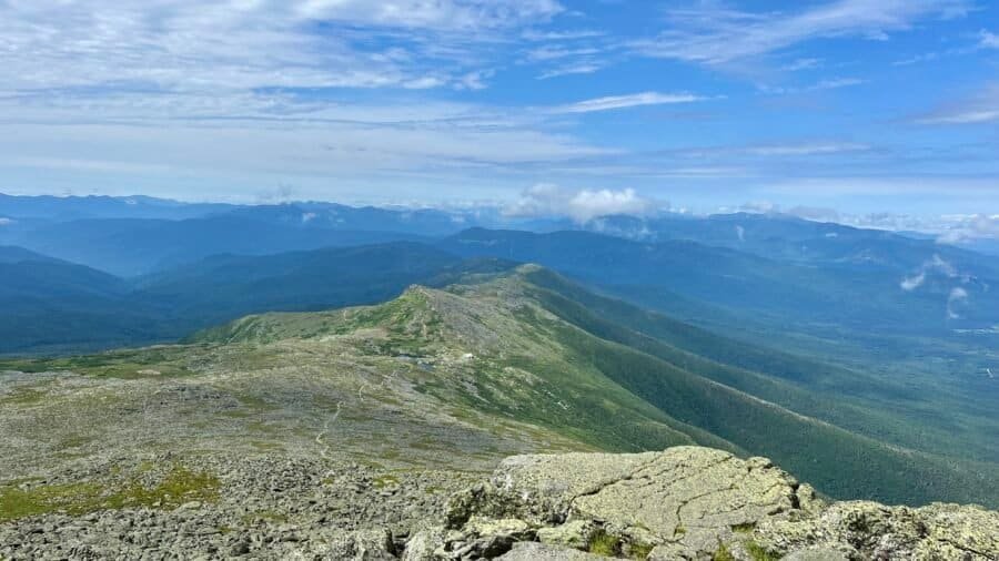
Mount Washington is New Hampshire’s highest point at 6,288 feet above sea level, ranking #18 among U.S. state high points and marking my 11th summit on this journey. It’s also one of those places where the mountain itself is only part of the story.
Before getting into Mount Washington, I should acknowledge the long pause in writing. There’s been a lot to catch up on—and if I’m being honest, I think I was procrastinating a bit. I knew this post carried more weight than most, both personally and historically, and I wanted to take the time to get it right.