What a contrast from Smugglers Notch State Park, Vermont to Britton Hill, Florida, and it’s been quite an interesting few weeks. Having visited most of the State Parks on my list of the Best State Park in each State and summited most of the High Points on the East Coast, I took a bit of a break from both of these lists. However, I didn’t take a break from exploring – I’ll add some of these finds in my Fun Finds section.
Britton Hill, no Sherpas needed
Britton Hill, the “mountain” of Florida, my 23rd State High Point, proudly stands at a towering 345 feet above sea level and has the dubious honor of being the lowest of high points ranking #51 in State High Points. So on a positive note, you can summit without a Sherpa and your grandmother can get to the top without breaking a sweat. Britton Hill is part of the picturesque Lakewood Park (not sure if I would go that far) and is surrounded by the tranquil landscape of the Florida Panhandle. Apparently there are three nature trails on which to wander and enjoy the local flora and fauna – the Yellow Trail (45 minutes), the Red Trail (90 minutes) or the Blue Trail (1 hour). I am not sure what trail I took, but it was a simple 1/2 mile loop around the park that took about 10 minutes – lol.
Getting There
Heading south from Montgomery, Alabama, it’s about 2 hours to Britton Hill. I took I-65 down to Georgiana, then Alabama 55 through Andalusia, and into Florala, Alabama (now that’s an original name). From there you take Alabama 54 to No Co HWY 285. The park is just past the Alabama-Florida border. As I drove down these country roads, and even going through these small towns, I realized how much of a dichotomy of wealth we have in this country and how much poverty we have in rural America. I also passed several cotton fields at the end of the harvest season.
Picture: Alabama Cotton Field
Short and Sweet
So the long and short of this summit – pardon the pun. The park has plenty of parking and a restroom. From the parking lot, it is a very short walk to the High Point Marker. The High Pointers Club has donated a bench, which you’ll see at many of the State High Points. And then there is a 1/2-mile trail to explore. Boom, drop the mike!
Pictures: Park Sign on County Road 285 | Park Sign with Restrooms in the background
Pictures: High Point Marker | High Pointers Club Bench
Picture: Summit Area with Trailhead in the background
Pictures: Summit Selfie | Walking Trail
Opportunity Knocks!
From here I was headed back to Tennessee, but I was a little hungry from the grueling climb to the summit of Britton Hill and decided to find a park and eat lunch. Looking north I found Opp, Alabama – yes that is a real name – and they say it’s the City of Opportunity. In all seriousness, I had to find out why it was called Opp. So here is your Jeopardy! answer – Who is Henry Opp. He happened to be a lawyer for the Louisville and Nashville Railroad and he lived and practiced law in nearby Andalusia.
The Frank Jackson State Park is located in Opp and I decided to go there for lunch. It was a quiet day, and as I drove into the park, there was actually an entrance booth, manned with a ranger. Unbeknownst to me, the park has an entrance fee. I was going to turn around, and I simply mentioned that I was just looking for a place to eat lunch. He let me in for free – I love the sense and hospitality of the South! It was near Halloween and the park was decorated with scarecrows for the Annual Scarecrows in the Park festival, a community tradition in Opp. So I had my lunch and checked out some of the scarecrows – but kept my distance from the water. lol
Pictures: Frank Jackson State Park | Don’t think I’ll be swimming anytime soon
Pictures: Scarecrows in the Park
Pictures: More Scarecrows in the Park
Next Stop….
I had thought about heading to Ichetucknee Springs State Park, Florida – on my list as the Best State Park in Florida, but with Halloween, they were having a special event, and honestly, I think it is best to visit when the weather is warmer as much of the experience is tubing on the river. I had also thought about visiting Fontainebleau State Park, Louisiana – on my list as the Best State Park in Louisiana, but due to recent storms, some of the park was closed. So I decided to head to Tuscaloosa and visit the University of Alabama – yes this Florida Gator stepped foot in Tuscaloosa! What can I say, I love the SEC (Southeastern Conference).
In my previous post about Mount Mansfield, I mentioned that the weather was not ideal for camping, and hotel rooms were expensive. As a result, I decided to stay in a hostel named Round Hearth Cafe and Market in Stowe, which I booked through Airbnb. Christopher, the host, was extremely friendly and an excellent host at the cafe as well. Additionally, the stay included complimentary coffee and a discount on food at the cafe. The hostel is not luxurious and is mainly intended for skiers, as indicated by the industrial carpet in the hallways (suitable for ski boots and snow). The rooms are plain but comfortable, and the shared bathrooms are super clean and well-lit. Since it was the off-season, I felt like I had the entire place to myself.
Pictures: Entrance to the Cafe and Hostel | Outdoor Seating Area
Pictures: Stairway to Rooms | Upper Hallway
Pictures: Hostel Room | Men’s Bathroom
That night, I decided to check out the area and found the Idletyme Brewing Company which was just down the road. I hung out in the bar area and had a chat with some of the locals. We talked about what to order for dinner and what to see at Smugglers Notch State Park. But then, an ambulance went by and they told me something creepy – apparently, the locals think someone has fallen at Bingham Falls every time they hear an ambulance. On that happy note, I had a great time and the food was pretty good.
Pictures: Idletyme Brewing Co. | Doubletyme IPA 7% | Fish and Chips
Work First, then a Hike
The next morning I had to do some work for a client, so I had breakfast in the cafe downstairs and worked on my project. It took a bit of time to complete, but there was still some daylight and I decided to head to the dreaded Bingham Falls – only a 5-minute drive up Mountain Road to the Trailhead.
Pictures: The Double Diamond Breakfast Sandwich with Avocado and Home Fries | The Cafe Interior
Pictures: The Round Hearth | Round Hearth Cafe Interior
First, a little about the park
Nestled in the heart of Vermont, Smugglers Notch State Park is a nature lover’s paradise that seamlessly blends breathtaking landscapes with outdoor adventure. Spanning over 1,000 acres, the park is a haven for hikers, boasting an extensive trail network that caters to all skill levels. Towering cliffs and dense forests create a picturesque backdrop, offering a serene escape from the hustle and bustle of everyday life. The park’s crown jewel, the famed Smugglers Notch, is a scenic mountain pass that weaves through rugged terrain, providing an exhilarating journey for those seeking a challenge. Visitors can relish in the park’s rich history, discovering tales of smugglers who once navigated these hidden paths. Whether you’re a seasoned trekker or a casual stroller, Smugglers Notch State Park invites you to explore its vast beauty and uncover the secrets held within its sprawling expanse.
Pictures: Trail Map | Trail Descriptions
There’s a reason it’s called Smugglers Notch
In 1807, President Thomas Jefferson passed an embargo act forbidding American trade with Great Britain and Canada. This was a severe hardship for northern Vermonters since Montreal was closer than other markets in the US. Many local people continued illegal trade with Canada, herding cattle and carrying other goods through the Notch. Later, fugitive slaves used the Notch as an escape route to Canada. During the Prohibition years, liquor was smuggled from Canada over the improved road built in 1922.
Top 5 Things to See
Smugglers Notch: The iconic mountain pass itself is a must-see. Marvel at the breathtaking rock formations and immerse yourself in the rich history of the area, where 19th-century smugglers once navigated through this hidden gem.
This is not hard to miss as the road runs right through the notch.
Sterling Pond: Hike to the pristine Sterling Pond, the highest trout pond in Vermont. Surrounded by mountains, this alpine lake offers a serene setting for picnics and a chance to connect with nature.
Compete – more later in the post.
Bingham Falls: A natural wonder awaits at Bingham Falls. Cool off in the refreshing cascades and pools, surrounded by lush greenery. It’s a perfect spot for a rejuvenating dip after a day of hiking.
Despite the warnings – I checked this off the list.
Long Trail: Traverse a section of the famous Long Trail, which runs through the park. Whether you’re an avid hiker or a casual walker, the trail provides stunning views of the Green Mountains and an opportunity to explore the park’s diverse ecosystems.
Although I didn’t do the entire Long Trail, I did portions near the Chin (see my Mount Mansfield post) and near Sterling Pond.
Moss Glen Falls: A short drive from the park, Moss Glen Falls is a picturesque waterfall worth visiting. Surrounded by lush foliage, it’s a photogenic spot and a tranquil setting to appreciate Vermont’s natural beauty.
Not to be confused with the Moss Glen Falls near Hostel Tevere that I wrote about in my Mount Mansfield post. I didn’t go to this particular Moss Glen Falls.
Let’s Conquer the Falls!
With my work complete, I decided to get a late afternoon hike in and headed towards Bingham Falls. The falls are named after Hiram Bingham, an American missionary, explorer, politician, and early settler in the area. It was carved by glaciers during the last Ice Age and has been a local favorite for cooling off and unwinding for generations. The park has numerous educational signs and well-marked trails, including those at the falls.
Pictures: Some of the educational signs you’ll discover
From the parking lot off Mountain Road, the trail is just a short 0.8 miles out and back. There’s a bit of elevation change, with the biggest challenge being the descent to the base of the falls. It’s a beautiful walk through the forest, which leads to the Upper Falls area. From there, there are steps down to the base of the falls. As I explored the area, I realized why people often get hurt or even die here – the rocks are incredibly slippery and there are no fences to prevent accidents. Therefore, it’s important to take your surroundings seriously and be cautious. I can only imagine how many people have been injured while trying to take a “cool” pic for Instagram.
Pictures: The initial portion of the trail
Pictures: The Upper Falls area
Picture: The West Branch Little River flowing into Bingham Falls
Pictures: Upper Falls
Picture: Bingham Falls
Pictures: The steep and slick trail down to the base of the falls
Trail Therapy
As I headed back to the parking lot, I decided to take a hike along the river. While on the trail, my attention was drawn to a young woman seated by the riverbank, immersed in her thoughts with headphones on. Respecting her space, I continued cautiously. Eventually, reaching the trail’s end, I retraced my steps. This time, our eyes met, and she removed her headphones. Greetings were exchanged, and I sensed an unease. As we chatted, she confided in me about her health struggles, likely stemming from mold in her flood-affected apartment, a result of recent Vermont floods. With empathy, I shared some fatherly advice, ranging from seeking legal assistance to moving out or finding a roommate. Encouraging and positive, I ensured she felt supported before I left her. This situation echoed a moment near my sister’s home, where a stranger stopped, concerned about my well-being – not that I looked distraught – but due to a recent suicide at the nearby falls. Compassion is priceless, reminding us to be attuned to others and their experiences. I believe fate guided me on that trail, and I sincerely hope she found a solution to her challenges.
Boxed Wine, Cheese and Crackers
After an emotional finish to the day and having successfully survived the hike to Bingham Falls, I headed to the market to buy some cheese, crackers, and boxed wine for dinner. Yes, I am a fan of boxed wines and have found some really good ones. In fact, years ago, I went to an incredible restaurant in France that only served boxed wine. So, I set up a spot outside at one of the cafe’s outdoor tables and enjoyed the sunset before heading to bed as I had a big day of hiking ahead of me.
Hiking: Day 2
The next morning, I packed up and headed out for a day of hiking. I had hoped to get out early, but had to tend to some business before hiking as I knew cellphone coverage would be spotty in the mountains. With my business finished, I headed to the Smugglers Cave parking area where I would first head to Sterling Pond and then Smugglers Cave. For a Tuesday with overcast weather, the parking lot was filling up fast, but I was fortunate to get a spot. I stopped at the information booth and spoke with the volunteer about the trails and such. He was a super interesting guy who had been a ranger in the Adirondack Mountains.
Picture: Informational Sign at Smugglers Notch
Pictures: Boulders at the Parking Lot | Overcast Weather
A Steep Climb and Lookout for Bears
The trail up to Sterling Pond is a moderately challenging route – keep in mind you are hiking up a trail to a peak that people ski down. The Sterling Pond trailhead is across the street and the trail is 2.1 miles out and back to just Sterling Pond with an elevation gain of 1000 feet – with most of the gain at the beginning of the hike. And just like Bingham Falls, the rocks were wet and slick, lending to a slower-than-normal hike.
Pictures: Sterling Pond Trailhead
Pictures: The steep and slippery hike to Sterling Pond
Pictures: More of the steep incline | One of the “pop-up” waterfalls and streams along the trail
At the top of the mountain, you reach a portion of the Long Trail – the same Long Trail that connects the Chin to the Nose to the Forehead on Mount Mansfield. The entire Long Trail spans 272 miles from Massachusetts to the Canadian Border and was the first long-distance hiking trail in the U.S. Although this portion of the hike wasn’t too steep, it was sheer rock and super slick due to the wet weather.
Pictures: Joining the Long Trail | Warning Sign | Slick Rocks
I hiked up to Sterling Pond, which is the highest-elevation trout pond in Vermont. It was a peaceful and beautiful spot, that is until a loud family could be heard in the distance. I continued my hike around the pond. The loop trail is about 1.4 miles long and includes some narrow sections and a few inclines, but nothing too difficult to navigate. The beginning of the trail was a bit challenging because some parts had been washed out, but I managed to make my way through. At the top of the ski mountain, which was still wet and swampy from recent rains, I checked out the chair lift platform, which was pretty cool. The trail around the pond wasn’t always easy to follow, and I ended up wandering around the summit a bit until I found a clearing and the trail again.
Picture: Sterling Pond
Pictures: Washed out Trail | View of Sterling Pond
Pictures: Ski Trail Sign | Top of the Notch Lodge
Pictures: Chair Lift Platform | Where the trail continues – through the opening in the trees
Shortly after I re-entered the woods, I came across a picnic table and a couple enjoying their lunch. I think I startled them as there were few hikers in this area. From here I headed down the Elephant’s Head Trail and this is where things got a little interesting. To begin with, it was super quiet and I was the only person on the trail. Then the initial part of the trail, along Sterling Pond, is quite narrow and there are a series of small inclines and declines through narrow rock gorges. It wasn’t anything I couldn’t navigate, but challenging at a couple of points.
Pictures: Elephant’s Head Trail Marker | The “loud” family that was behind me – now off in the distance
Picture: Sterling Pond – from the other side
Pictures: One of the narrow gorges to maneuver through | The beauty of the forest
After you leave the area around the pond, there is another intersection and you continue on the Elephant’s Head Trail, which now takes you through the forest. From here it is an uphill climb, then back down. It was at this point that I began to see tracks in the mud. I had seen several dogs on the way up to Sterling Pond, but these were much bigger than the average dog. I suspected they were bear tracks! As a note: When I got back to the parking lot, I showed the ex-ranger and volunteer my photos of the tracks and he confirmed that they were bear tracks. I’m glad I was hiking with my bear spray! Eventually you connect back to the Long Trail.
Picture: Bear paw print in the mud
Pictures: Back to the Long Trail | The Long Trail – heading towards Sterling Pond Trail
Once I got back to the Sterling Pond Trail, I headed back down the mountain to the parking lot. Along the way, I ran into a guy who was taking pictures of birds. He said it was a quiet day and he hadn’t seen many birds, but what I thought was cool – he was there on his lunch break from work. How cool to have this in your backyard and hike on your lunch break!
Looking for Smugglers!
After returning to the parking lot, I unloaded my backpack and poles and took a break to eat and drink. The weather was improving and the area was getting busier with more cars waiting for parking spots. Once I finished my lunch, I went back to the information booth to ask about the bear tracks and to get more information about the Smugglers Cave. I was happy to find out that the cave was located right behind the booth and there was a short loop up and around the caves. The cave was quite interesting, and I could imagine smugglers hiding out there in the past. It was a great way to end my day. I am happy that I split my visit into two days, as there is so much to explore and enjoy at Smugglers Notch State Park! I would definitely recommend a visit to this beautiful park.
Pictures: To Smugglers Cave | The History of Smugglers Notch
Pictures: Smugglers Cave
Picture: Smugglers Notch
Time for a Beer
With the day relatively young, and Burlington, Vermont close by, I headed east to check out their craft brewing scene and to see a town I have been wanting to visit for some time. My first stop – Queen City Brewery – where I enjoyed a flight of beer and met a nice couple from the West Coast of Florida. We chatted about Florida Breweries and I mentioned my love for IPAs. They suggested I try Zero Gravity Brewery across the street as are known for their IPAs.
Pictures: Queen City Brewery
Pictures: Beers of the Day | My Flight of Beer
After finishing my flight, I headed across to the street to Zero Gravity Brewery where I picked up a few different IPAs in cans. With beers in hand, snacks in my cooler, and the golden hour approaching, I headed to nearby Oakledge Park to see the sunset on Lake Champlain. I sat on the rocks and watched an incredible sunset. It was a great way to end an incredible day!
Pictures: Waiting for Sunset | Ferry crossing Lake Champlain
Welcome to Vermont – Land of Maple Syrup, Cheese, Covered Bridges and Bernie Sanders
Ok – I know there are many other things that the state is known for – such as skiing, The Green Mountains, outdoor activities, and craft breweries. So from the Mid-Atlantic Coast, I headed back to New England to conquer Mount Mansfield and visit Smuggler’s Notch State Park. As I drove north from Massachusetts on I-91, I made a stop at the Guilford Welcome Center Home to get some maps and to see what I could learn about Mount Mansfield and Smuggler’s Notch. It’s one of the most beautiful welcome centers you will come across – complete with Barn Art, a Crabapple Orchard and a playground.
Pictures: Welcome to Vermont | Barn Art
Once I figured out where to stay for the night, I hit the road again. I didn’t have to travel too far up the Interstate before I had to exit and from that point on, I was cruising on back roads – which I totally loved! As I neared my destination I came across a waterfall – Moss Glen Falls – which I naturally had to stop at. Moss Glen Falls is about 9.5 miles south of my destination on VT-100.
Picture: Moss Glen Falls – Granville, VT
A Hoteling we go
With the wet weather – camping was not the best option – and hotels and Airbnb’s were at a premium, so decided to stay at two different hostels on my visit to Vermont. The first was Hostel Tevere, a little over an hour south of Underhill State Park, where I would start my ascent of Mount Mansfield. Hostel Tevere is a 4 room – 23-bed hostel, with an interesting twist – it has a restaurant on site – Déco, which serves Dinner Thursday – Sunday 4 pm – 9 pm.
Picture: Hostel Tevere
The Hostel is pretty basic – shared dorms and single bathrooms throughout. For the most part, it was quiet, but there was a group that came in late-ish to the room next door and they had a conversation about the next day. And I did have a roommate for the night – an older woman there for a yoga retreat. She was quiet and up early the next morning as well.
Pictures: My Dorm Room | My Bed – #18
I decided to try Déco for dinner, and happy that I did. The service was fabulous, they had a great selection of unique beers, and the food was very good. I kept it simple and had a Loaded Grilled Cheese (Vermont Cheddar, Apple, and Caramelized Onion – I left off the bacon as I’m a pescatarian), French Fries with Mayo – Mais oui! – and a beer. It was certainly not what I expected at a Hostel!
Pictures: The Bar Area | Beer | Loaded Grilled Cheese and French Fries
About Mount Mansfield
Mount Mansfield, situated in the northern portion of Vermont, stands as the state’s highest peak at 4,393 feet, ranks #26 in State High Points, and was my 22nd High Point. Renowned for its striking alpine scenery, the mountain is a focal point of outdoor enthusiasts, offering a diverse range of recreational activities. Boasting a distinctive profile resembling a human face, it is aptly named “The Chin.” Avid hikers are drawn to the challenging trails, such as the popular Long Trail, which leads to the summit and rewards adventurers with breathtaking panoramic views of the Green Mountains and surrounding landscapes. During winter, Mount Mansfield transforms into a winter sports haven, featuring a ski resort that caters to both beginners and experienced skiers alike. The mountain’s ecological significance is underscored by its rare arctic-alpine vegetation and diverse wildlife. Serving as a natural playground and an ecological gem, Mount Mansfield captivates visitors with its scenic beauty and recreational opportunities year-round.
Dreary Day for a Hike
The next morning I got up, grabbed some coffee at the Hostel, chatted with the owner for a bit, and then headed out. I decided to start my hike at Underhill State Park – 1 hr. 10 min north of the Hostel. As I got closer to the park, I passed several cyclists including two younger guys, whom I met later in the park at the Sunset Ridge Trailhead. The day was a bit overcast with low cloud cover and an occasional light rain.
Mountain Road, the road that leads up to the park, has a bit of an elevation and I could not imagine biking up to the park. Eventually, you end up in the parking lot, where there is a small office where you pay the $5 parking fee.
Pictures: Underhill State Park | Park Map
Gunshots in the Distance
From the parking lot, you hike up Eagle Cut Trail which crosses Mountain Road/CCC Road several times to the Sunset Ridge Trailhead. It’s a nice 1-mile warm-up before you begin the serious hike. At the Sunset Ridge Trail, I met the two guys who had biked up to the park and found out that they rode from Burlington, some 20+ miles away! But what made it worse for me, was they cruised up the mountain ahead of me. We chatted a bit and then heard the gunshots in the distance. They told me that the Ethan Allen Firing Range – a US Army weapons testing area – was nearby. It was a little reassuring as I didn’t have to worry about being poached by hunters.
Tale of Two Trails
From this trailhead, you eventually have two choices to the summit, the shorter Laura Cowles Trail (1.7 miles up to the Chin) and then the slightly longer Sunset Ridge Trail (2.3 miles up to the Chin). With the slick conditions, I opted for the Sunset Ridge Trail as the Laura Cowles Trail is listed as very difficult. The trail has several rocky areas, which normally are not difficult to maneuver, but with the wet conditions, they were quite slick. And with these conditions, I took very few pictures on this hike.
The first section of the trail offers a breathtaking hike through the woods. As you continue, you will come out of the tree line and start to get a glimpse of the scenery, although it was limited for me. The exposed rocky areas can be challenging, but still doable.
Pictures: The initial portion of the Sunset Ridge Trail
Pictures: Where the trail splits | One of the giant boulders you’ll hike around
Pictures: Some of the slick rocky areas
Pictures: Leaving the covered forest | One of the challenging exposed rocky areas
Picture: The only real view of the day
A summit with no view
Once you reach the Long Trail, it’s a short hike up to the Chin and the highest point in Vermont! On a sunny day, you can see the Champlain Valley and Adirondacks. But today, I saw fog and had no view! The summit does have a geodetic survey marker and as I look back at the pictures, the landscape reminded me of Iceland.
If the day had been a little nicer, after reaching The Chin, I would have taken the Long Trail to The Nose and then to The Forehead. From there, down the Maple Ridge Trail to the CCC Road and back to the parking lot. If I had done this loop, it would have been a total of 7.7 miles for the day or about 7-8 hours. Maybe next time. Despite the weather, this was a great, challenging hike that I would highly recommend.
Pictures: Trail Intersection – the Laura Cowles Trail and the Long Trail | Final hike to the summit
Pictures: Survey Marker | Looks a bit like Iceland
Pictures: Summit Selfies
Pictures: Views from the Summit – if you can call it a view
Next Stop…
With Mount Mansfield checked off my list, I headed to Stowe, Vermont for hostel #2 and to visit Smuggler’s Notch State Park – on my list of Best State Parks. Stay tuned for that post! And as a note, on my visit to Vermont, I didn’t see Bernie Sanders, but saw my first black bear in the wild. It sprinted across the road as I was driving to Stowe.
As I continue to visit the Discoverer’s List of Best State Parks in Each State, I am seeing some themes, but I also have started asking rangers and volunteers why they think their park is the best in their state. The Ranger at First Landing State Park thought for a minute and thought it was because of the diverse ecosystems in the park. I personally think it is because it is the most visited State Park in Virginia. So as I reflect on my visit, I did find the diverse ecosystems to be fascinating.
The parking fee is $7 and on weekends from April to October, it’s $10. As many of you know, I am not in favor of park fees, but at least this is by car and somewhat affordable for a family of $4 in one car. There are three different areas for the park – two entrances off of Shore Drive – to one side is First Landing Beach, the Visitor Center, and the Camp Grounds. On the other side is Cyprus Swamp Road, which will take you to the trail center. Additionally, there is an entrance of off Atlantic Avenue at 64th Street.
It was a hot and humid day, but thankfully it was overcast. It also looked like the weather was going to turn, so I did a drive-by at the beach area and focused my visit on the Trail Center area and then the area near the 64th Street Entrance.
Pictures: First Landing State Park – Beach
Pictures: Entrance Sign | Trail Map
About the Park and more work by the CCC
First Landing State Park, nestled along the shores of the Chesapeake Bay in Virginia, is a coastal haven that seamlessly blends natural beauty with historical significance. Spanning over 2,800 acres, this state park holds the distinction of being the site where English settlers, led by Captain John Smith, first touched the shores of the New World in 1607. The park’s name itself pays homage to this momentous event, marking the initial landing of these pioneers. Built in part by an all African-American Civilian Conservation Corps in 1933-1940, the park is a National Natural Landmark and is listed in the National Register of Historic Places.
As Virginia’s most-visited state park, it’s an oasis within urban Virginia Beach. The park has 20 miles of trails and 1.5 miles of sandy Chesapeake Bay beach frontage. First Landing offers many recreational and educational activities and has many unusual habitats including bald cypress swamps, lagoons and maritime forest, as well as rare plants and wildlife.
Camping enthusiasts can immerse themselves in the natural surroundings by staying at one of the park’s campgrounds, offering a unique opportunity to connect with nature. Educational programs and interpretive displays further enrich the visitor experience, shedding light on the region’s ecological and historical significance.
Please note: The park is located beside a military training center that operates year-round in any weather at any time of day or night. Park guests may experience unusual sights and loudness. Nighttime training may last even beyond midnight. The activities pose no risk to park guests.
Let the Hiking Begin
As you can see from the picture below, the trails in this park are well-marked. At the entrance of the Trail Center is a fox – a life-size, life-like bronze red fox created by Sculptor David Turner of Turner Sculpture on the Eastern Shore. Friends of First Landing State Park chose a fox for the sculpture because foxes are prevalent in the park and also because a fox is Virginia State Park’s mascot.
From the Trail Center parking lot, I decided to explore the swampy area first and take the Bald Cypress Trail. This hike takes you across a raised walkway through the trees and over the swamp. I did keep a keen out for snakes in the swamp, but didn’t see any, which I was super bummed about.
Pictures: “Fox on Alert” | Well Marked Trails
Pictures: Raised Walkway through the Swamp
Time for a Wardrobe Change
I hiked the Bald Cypress Trail which led me to the Cape Henry Trail. Then I reconnected with the Bald Cypress Trail and finally connected to the Fox Run Trail. As indicated by my previous sentences, many trails intersect each other near the Trail Center, making it a maze of trails. I walked a bit down the Fox Run Trail but soon realized I was uncomfortable. So, I turned back to the parking lot, changed my clothes, and grabbed a rain jacket along with some more water and snacks. After that, I restarted and walked again down the Fox Run Trail. Personally, I have no problem restarting a hike if I feel uncomfortable.
Fox Run connects to Long Creek Trail. This is a nice hike along Long Creek, although I was quickly reminded that I was in the middle of a city as I began to hear leaf blowers and the sound of hammers from a nearby construction site.
Pictures: Along Long Creek Trail
Mushrooms and Spanish Moss
While exploring the park, I discovered various mushrooms and Spanish moss. As a child, I was fascinated by Spanish moss and would look for it every year on our trip to Ormond Beach, Florida.
Pictures: Some of the many mushrooms I found in the park
Pictures: Spanish Moss
The Mystery of Unknown Waters
“The marsh, to him who enters it in a receptive mood, holds, besides mosquitoes and stagnation, melody, the mystery of unknown waters, and the sweetness of Nature undisturbed by man.” ― William Beebe, The Log of the Sun a Chronicle of Nature’s Year
The Long Trail passes through a cool marsh, filled with many hidden secrets beneath the unknown waters. Along the way, you will encounter observation towers that are perfect for bird watching and also witness the natural wonders of the area, such as crabs. The trail runs parallel to Broad Bay, where Long Creek flows in. And yes, bugs and mosquitoes are common in this area of the park.
Pictures: Looking out towards Broad Bay | The Marsh
Pictures: Observation Tower | Local Crab
Pictures: More of the Marsh
What do I hear in the distance?
While hiking on the Long Creek Trail, I heard a strange bird call in the distance. I decided to follow the Osprey Trail to investigate, and to my surprise, I discovered an Osprey perched on a dead tree. It seemed as though the bird was inviting me to come visit. The Osprey Trail has some uphill sections, as well as a stretch that runs along a beach and Broad Bay. As the trail moves away from the beach, you’ll cross a bridge and go over a tributary. The amber color of the water reminded me of Black Water Falls State Park in West Virginia where the water gets its amber color from the pine needles.
Pictures: The Osprey | Osprey Trail along the Beach
A lot of Backtracking Today
After crossing the bridge, I decided to turn around and head back up the hill. I took the Long Creek Trail to the White Hill Lake trail with the goal of reaching the “summit” of White Hill, which has an elevation of 33 feet. As I hiked up towards White Hill, I encountered a turtle crossing the trail. The turtle didn’t seem pleased to see me and quickly retreated into its shell.
Picture: The Turtle
A Great Place to Exercise
I didn’t take much time to reach White Hill. After that, I turned back and took the Long Creek Trail. I walked a short distance on the trail and later took the Kingfisher Trail, which led me to the Cape Henry Trail. The Cape Henry Trail is a mixed-use trail that caters to both hikers and mountain bikers. Along the way, there are various exercise stations, and I also passed several trail runners. I love trail running and would come here frequently for a run if I lived nearby.
Soon I was back to the Trail Center. I did a total of 6.5 miles, which took me 2 hrs. 30 minutes to complete. From here, I decided to drive to the 64th Street Entrance and explore that part of the park.
Pictures: One of the Education Signs | One of the Exercise Stations
Humans can be Horrible and Destructive
“It’s just a short drive to the 64th Street Entrance. This part of the park wasn’t very busy, though I think it would be if the weather were nicer. It began to sprinkle as I explored this section of the park. There is a cool beach to explore, as well as a maritime forest. The Narrows are also located here, which connects Linkhorn Bay with Broad Bay, and is filled with oysters as thick as stones. I ran into several families exploring the beach, as well as a few guys fishing. Unfortunately, my last impression of the park was an abundance of trash and graffiti on the trees. It’s sad to see how people can be so horrible and destructive.”
I was pleasantly surprised by First Landing State Park’s diverse ecosystems, historical significance, and recreational offerings. It’s a natural haven worth exploring, especially if you are vacationing in the area.
Pictures: The Beach at the 64th Street Entrance
Pictures: Some of the cool trees and wood along the beach
I had been to Myrtle Beach in the past year and to be honest it was not one of my favorite places. It should be with my Greek heritage and being a restauranteur – thanks to generations of Greek restaurateurs who set out to fill a need for vacationers, pancake houses abound in North Myrtle Beach. So when I saw Myrtle Beach State Park on the Discoverer’s List of The Best State Park in each State, I was a little skeptical, to say the least. I will have to say, that despite my skepticism, I was pleasantly surprised by my visit. So if you’re visiting Myrtle Beach, South Carolina – take time away from the souvenir shops, dinner theaters, attractions, and pancake houses, and make an effort to visit Myrtle Beach State Park. I would add that there is a fee to enter the park – and as many of you know, I believe in fairness, equality, and accessibility – consequently, I am against high entrance fees. One positive note on the fees, you can go in and out of the park on the same day – which was a benefit to me as you’ll see later on in this post. Here is the list of fees: $8 adults; $5/SC seniors (age 65 & older); $4/ child age 6-15; Free for children 5 and younger.
Pictures: Entrance on South Kings Highway | Park Map
About the Park and the CCC Strikes Again!
Myrtle Beach State Park, nestled along the stunning coastline of South Carolina, stands as a natural haven, offering a diverse range of attractions for nature enthusiasts and beachgoers alike. Spanning 312 acres, this coastal gem is a testament to the state’s commitment to preserving its natural beauty.
The park was developed by the Civilian Conservation Corps (CCC), a New Deal Program created by President Franklin D. Roosevelt. The program was designed to provide employment during the Great Depression while addressing national needs in conservation and recreation. I am finding this as a common theme in the Discoverer’s list and southern state parks.
One of the highlights of the park is its pristine beach that stretches for a mile along the Atlantic Ocean. Visitors can enjoy the sun, take a refreshing dip in the sea, or explore the shoreline for seashells and other marine treasures. The maritime forest, declared a Heritage Trust Site, showcases a unique ecosystem with a variety of indigenous plant and animal species. Hikers can explore the rich biodiversity of the forest through nature trails that wind through towering pines and myrtle bushes.
If you ever visit Myrtle Beach State Park, don’t forget to check out the Nature Center, which offers interactive exhibits and educational programs about the park’s ecology and wildlife. Unfortunately, the center was closed during my visit. You can also enjoy the park’s picnic areas and campgrounds, making it an excellent choice for a day trip or an extended outdoor adventure. The park is also renowned for its fantastic surf fishing spots, with stunning ocean views, and Myrtle Beach pier offers another great fishing location.
Pictures: The CCC and Myrtle Beach State Park | The Pier
Trip #1
Yes, I made two different trips to the park and was happy to learn they had in-and-out privileges. I did a little research about the park and came across this list of five things to do at the park. And the last item on the list piqued my interest.
TOP 5 THINGS TO DO
Enjoy an ice cream cone from the gift shop while taking a stroll out on the fishing pier.
Explore nature at the Nature Center or on a self-led scavenger hunt.
Hit the beach and search for shells, sea creatures and sharks’ teeth.
Escape the busy Grand Strand and enjoy a walk on the Sculptured Oak Nature Trail through the beautiful maritime forest.
Wake up early and relish in the peace and solitude of the park as you enjoy watching a sunrise.
Sunrise, here we come…
So early that morning, I got up and was happy the hotel had coffee ready. I grabbed two cups of coffee to go as I knew I would be gone for a bit and off I went. I was a little surprised that upon my arrival at the park, there was an attendant already there, collecting the entrance fee. I paid my $8 and in I went. I drove to the beach, parked my car and then found a spot on the beach to watch the sunrise. For the most part it was peaceful, but soon the “noise window” was open and planes began taking off from nearby Myrtle Beach International Airport. Nonetheless, I was happy to see the sunrise and had the beach nearly to myself.
Pictures: The many phases of sunrise
Pictures: The many phases of sunrise
Picture: The sun emerges
Pictures: Footprints in the sand | The many phases of sunrise
Pictures: And so the planes begin taking off | The raised walkway at sunrise
Pictures: One of the picnic areas | The pier at sunrise
Back to the Hotel
After enjoying the beautiful sunset, I went back to the hotel for the complimentary breakfast and to pack my things as I decided to head out to my next destination after I visited the park.
Myrtle Beach State Park, Round 2
On my second visit to the park, there were a few cars ahead of me at the entrance, but it wasn’t too bad. I parked my car near the fishing pier, as that was my next stop. As expected, the park was beginning to get busier. The pier provides great views of the beach and has a tackle shop, a gift shop, and an ice cream stand. A few people were fishing on the pier, but the end of the pier was closed due to some damage caused by a hurricane. As a result, some of the deeper fishing spots were unavailable. In addition, there were some oversized chairs that visitors could sit in and get a souvenir photo.
Pictures: Views from the pier
Pictures: Oversized chair | The Pier
Pictures: The closed portion of the pier | Swinging bench near the pier
Dressed to hike!
The trails are not very long, but I had read about the wildlife and decided to put on my hiking boots and bring my hiking poles. I did get a few looks from families – Like who is this guy? Doesn’t he know he’s at the beach? The park has copperhead snakes, and if you know anything about these snakes, you know why it is important to have poles and wear boots. Unlike other viperids, copperheads often “freeze” instead of slithering away, and as a result, many bites occur due to people unknowingly stepping on or near them. So off I went to the furthest trail – the Youpen Trail – named after an evergreen tree that can grow up to 30 feet tall – the Yaupon Holly (lex vomitoria). In the fall and winter, yaupon has bright red berries that are an important food source for birds and small mammals, and in the spring, yaupon develops pretty white flowers.
Pictures: Yaupon Trailhead | The Yaupon Trail
Be very, very careful….
Soon I came across three logs covered with mushrooms. And if you have read any of my earlier posts, you know I have a fascination with mushrooms. So I moved in to get a closer picture of the mushrooms, and then I saw it! A copperhead, “frozen” in the middle of the logs! I slowly moved away and made a note of the location so that I could let the rangers know. As an FYI – you can tell that it is a copperhead by the brown “Hershey’s Kisses” on the snake’s body.
Pictures: The 3 logs with the mushrooms and copperhead snake | The copperhead snake
More interesting wildlife…
Along the trails, I also saw a pink-striped oak worm moth (at least that is what both Google Lens and Apple Photo identified it as) and an American five-lined skink. The skink I had to go back and get the picture as it darted away the first time I was trying to get a picture. The trail eventually connects with the Sculptured Oak Nature Trail. I took this first to the left and to the “pond.” I am sure under all the fauna, there is a pond, but it was hard to see.
Pictures: Pink-striped oak worm moth | The Pond
Pictures: American Five-lined Skink | Another interesting mushroom
As you walk through the park, hopefully, you’ll be lucky enough to see the many blooming species of plants – such as the aquatic pickerelweed, hibiscus, and saltmarsh morning glory. Additionally, I came across the American Beautyberry and some cool trees.
Pictures: A fallen tree that I thought was super cool | American Beautyberry | Another cool tree
From the pond, I went back towards the beach on the Sculptured Oak Nature Trail. There are places on the trails to sit and enjoy nature, but something about sitting on a raised platform and knowing that there are snakes in the area, didn’t sit well for me – pardon the pun!
Pictures: Sculpture Oak Nature Trailhead | One of the benches to sit and enjoy nature| The Sculpture Oak Nature Trail
Picture: The Sculptured Oak
Completing the list
With items 3, 4, and 5 checked of the TOP 5 THINGS TO DO at Myrtle Beach State Park, I decided to reward myself with the first item on the list – enjoy an ice cream cone from the gift shop while taking a stroll out on the fishing pier. Espresso Chip please!
Picture: Espresso Chip Ice Cream Cone
The last item on the list was to visit the Nature Center. As it was on the way out, I decided to drive and park near the Nature Center. Additionally, the Park Office is across the street and I was able to let them know about the Copperhead Snake in the event they wanted to relocate the snake. After my report, I went to the Nature Center, but it was closed the day I was visiting. It wasn’t a total bust as I got to see a couple of Golden Silk Orbweaver Spiders.
Picture: Golden Silk Orbweaver Spider
I definitely made the most out of my visit to the park but will say that I don’t think I would make a special trip. However, if you are in the area, make an effort to visit the park, you’ll be happy you did!
As it was the end of the summer and it was a Monday night, hotel rooms were fairly abundant. I am intrigued by the renaissance motels or motor lodges are making and if I have a chance to stay at one, I will go out of my way to do so. Fortunately, I found the Heart of Manteo Motor Lodge – about 10 miles or 15 minutes across the Roanoke Sound to the entrance of Jockey’s Ridge State Park. The rooms were pretty simple, and almost reminded me of a dorm room, but they were super clean, comfortable and had all the amenities I need for a one night stay. I will have to say the check-in process caught me off guard a bit, but it was fascinating. You walk into the first part of the lobby (the main lobby doors are locked and closed), you are directed to a kiosk. As you approach the kiosk, a live person pops up on the screen (most likely motion activated and the people are off-shore), and they check you in. Your ID is scanned, a key comes out of a slot, and a receipt is printed with WiFi info, an emergency number and your room number. I thought it was super cool and efficient – although lacking any sort of personal hospitality. Nonetheless, I think it was one of the highlights of my trip.
Pictures: Hotel Sign | Check-in Kiosk
Pictures: My Room | Front portion of the Motor Lodge
Lessons Learned
I really am trying to do a better job at researching parks and peaks, before I visit them, but I am still not 100% there. So a few lessons learned – Lesson #1, it was hot as heck out, and being a small park, I never thought about bringing water or a cold drink with me as I explored the dunes. I definitely could have used something to drink! Lesson #2 – Kitty Hawk is nearby and they have a hang-gliding school – so it’s a great place to fly things – like a kite! I should have brought a kite with me. Lesson #3 – be cognizant of sunrise and sunset. I need to make sure I am visiting the park or peak at the optimal time for views and either a sunrise or sunset. With any luck, maybe these tidbits will help someone as they explore.
Early that morning I headed to the park, but only after stopping at Dunkin’ Donuts for some morning fuel. With coffee in hand, I drove to the park. I should note there are two parking areas – the main parking area is off of S. Croatan Highway (where I parked) and the other parking area is off of West Soundside Road. I was also happy that there was no entrance fee for the park, making it accessible to all.
Pictures: Dunkin’ Donuts in Manteo, NC | Park Entrance
About the Park
Jockey’s Ridge State Park, situated along the Outer Banks of North Carolina, stands as a captivating natural wonder and a testament to the state’s diverse landscapes. Encompassing over 400 acres, it is renowned for hosting the tallest living dune system on the Atlantic coast. The park’s centerpiece, Jockey’s Ridge, reaches heights of up to 100 feet, providing a stunning panorama of the surrounding coastal scenery.
Visitors to Jockey’s Ridge State Park are drawn to its unique ecosystem, characterized by shifting sands and diverse plant and animal life adapted to the challenging conditions. The park is a haven for outdoor enthusiasts, offering opportunities for hang gliding, kite flying, and hiking across the undulating dunes. Sunset strolls along the ridge are particularly popular, treating visitors to breathtaking views as the sun dips below the horizon, casting hues of orange and pink across the sandy landscape. The park also marks the eastern terminus of the Mountains-to-Sea State Trail.
Beyond its natural allure, Jockey’s Ridge State Park serves as an educational hub, with programs and exhibits exploring the geological history of the region, emphasizing conservation efforts, and highlighting the importance of preserving this fragile ecosystem. Whether seeking an adrenaline-fueled adventure or a serene escape into nature, Jockey’s Ridge State Park provides a dynamic and awe-inspiring destination for all who venture to North Carolina’s Outer Banks.
Pictures: Visitor Center | Park Map
What’s in a Name?
The name, Jockey’s Ridge, is a mystery as to its origin. Perhaps it came from the practice of the early “bankers” who used the flats around the base of the dunes to race the Spanish mustangs that ran wild in the area while spectators watched from atop the dune. More likely, the name may have originated as a result of the ownership of the dune by a family with the name of, or similar to, Jackey. Personally, I think it is a combination of the two theories and someone “heard” Jockey because of the mustangs, instead of “hearing” Jackey.
Footwear Required!
I started at the Visitor Center to learn more about the park and the dunes. This is also where the hang-gliding school is located. From there I headed out to the dunes along the boardwalk – and yes I wore shoes. lol While strolling along the boardwalk, you’ll find informative signs about the local environment, such as the oak trees and mockingbirds. Eventually, you’ll end up at the observation deck, where you can walk down and explore the dunes.
Pictures: Hang-gliding School | Directional Sign | Entrance to the Boardwalk (not the footwear sign)
Pictures: The Boardwalk | A Live Oak Tree | About the Mockingbirds
Pictures: Observation Deck | View of the Dunes from the Observation Deck
What Trails?
From the map, you’ll see there are two trails – one to the Ridge Top and other the Tracks in the Sand. But as the park brochure notes: The nature of shifting sand prevents the construction of traditional trails in the park and so you just end up exploring and walking, which I had not issues with. However, with the heat, I thought I was wandering around aimlessly in the Sarah Desert looking for an oasis. The Tracks in the Sand is a 1.2-mile self-guided trail composed of 14 stations. (I didn’t do all the stations) The hike takes approximately 1.5 hours, beginning at the parking lot and meandering through the many environments in the park.
Pictures: Start of the Tracks in the Sand | There really is some elevation change here!
Pictures: The Sand Dunes
Pictures: Kite Flying on the Dunes
Pictures: The Dunes and Roanoke Sound
What are they looking at?
As I headed back toward the Observation Deck, I saw a family looking at something on one of the dunes, so naturally, I had to find out for myself. I was shocked and pleasantly surprised to see a box turtle! But so far from any water. I felt bad, but live by the motto, leave nature alone, unless it’s the result of a man-made issue. I also saw a cool piece of driftwood as I meandered through the dunes. Eventually, I was back at the Observation Deck, a bit parched and ready for lunch!
Pictures: Box Turtle | Driftwood
Pictures: More Dunes | The Observation Deck from the Dunes
Lunch
After an exhausting day, I rewarded myself with a little lunch at Tortugas’ Lie in nearby Nags Head, NC. I should say literally up the street from the park entrance. I had the Catch of the Day Sandwich – Yellowfin Tuna – with Island Fries and a local lager. It was a pretty good place to recharge before I headed out.
Pictures: Tortugas’ Lie | Catch of the Day Sandwich – Yellowfin Tuna
Overall, Jockey’s Ridge State Park was nice. I would definitely combine it with a longer visit to the OBX (code abbreviation for the Outer Banks). And I would bring a kite, cold drink and stay for the sunset.
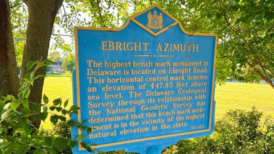
Ebright Azimuth sits in northern Delaware, just north of Wilmington and only steps from the Pennsylvania–Delaware border. At 448 feet above sea level, it ranks #49 among U.S. state high points and became my 21st state high point — a very different experience than my previous summit, Mount Mitchell.
At 6,684 feet, Mount Mitchell stands as the highest point east of the Mississippi River — and, as a result, became my 20th state high point. Since it’s just outside Asheville, I stayed there the night before and set my alarm early, hoping to beat both the crowds and the afternoon haze that often rolls through these mountains.
Sassafras Mountain rises to 3,553 feet, making it the highest natural point in South Carolina and ranking #29 among U.S. state high points. Sitting right on the border with North Carolina, Sassafras is one of those summits you can drive to—but after days of moving through the Carolinas, I wanted this one to feel earned.
This stop marked my 19th state high point, and while Sassafras Mountain is approachable by design, it still offered a choice: convenience or effort. I chose the longer way up.
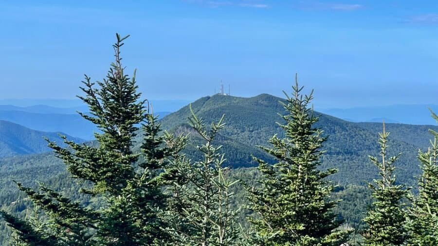
At 6,643 feet above sea level, Clingmans Dome—now officially known as Kuwohi—is the highest point in Tennessee, ranking #17 among U.S. state high points and rising along the border of Tennessee and North Carolina within Great Smoky Mountains National Park. This was my 18th state high point, and while reaching the summit itself turned out to be fairly straightforward, everything leading up to it was a reminder of why preparation—and a little patience—matters more than you think.
I tend to travel with the wind. Most of the time that works in my favor. Occasionally, it nearly costs me a summit. Clingmans Dome was almost one of those occasions.