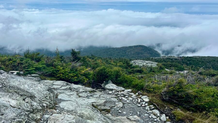
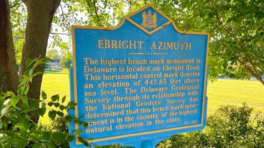
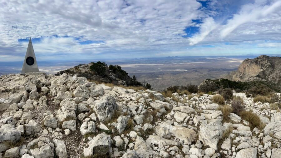
sharing my love for philanthropy, cooking, and adventure

Sunrise illuminating the summit glacier on Mount Kilimanjaro, with ice formations in the foreground and a sea of clouds in the background.

Tag: High Pointers Page 2 of 4

Guadalupe Peak | Texas (#27)

The day I hiked Guadalupe Peak was filled with so many emotions. I had read many of the reviews on AllTrails, my go-to hiking resource, which gave me a bit of angst. For example, “The last 100 yards are a bit scary as you can see a long way down and the rocks are slick.” Couple this with the fact that it is an 8.4-mile out-and-back trail with an elevation change of almost 3,000 feet, I was a bit nervous, to say the least, and I had visions of my challenging hike to the summit of Mt. Katahdin on Abol Trail. In the end – Was it hard? – Heck yeah; Was it as hard as Katahdin? – Not even close; and Were you happy you did it? – One word: Ecstatic! So there you have it!

Let’s talk about the Beast of Texas: Guadalupe Peak

Guadalupe Peak, located in Guadalupe Mountains National Park, Texas, stands as the highest point in the Lone Star State at 8,751 feet above sea level, ranks #14 in State High Points, it’s the tallest state high point under 10,000 feet, and was my 27th High Point. This iconic summit offers breathtaking panoramic views of the surrounding Chihuahuan Desert and rugged mountain landscapes. Hiking enthusiasts are drawn to the challenging Guadalupe Peak Trail, a strenuous 8.4-mile round trip that rewards climbers with a stunning view from the summit.

The peak is part of the ancient Capitan Reef, an ancient marine fossil reef that once thrived in a Permian sea over 250 million years ago. Today, visitors can marvel at the remnants of this geological history as they ascend the peak. The diverse flora and fauna, including agave and ponderosa pine, add to the unique ecological tapestry of the region. Guadalupe Peak is not just a geological marvel; it’s a testament to the rich natural heritage embedded in the heart of Texas.

Picture: Park Entrance

The 42nd Largest National Park

Spanning over 86,000 acres in western Texas, Guadalupe Mountains National Park is a vast expanse of rugged beauty. (I can’t believe there are 41 National Parks that are larger than this!) Renowned for its diverse landscapes, the park features soaring limestone canyons, expansive desert flats, and pristine fossilized reefs. McKittrick Canyon, a botanical wonder, showcases vibrant autumn foliage, attracting hikers to its picturesque trails. Carved by time, Walnut Canyon unveils ancient rock formations, while the historic Frijole Ranch offers a glimpse into the region’s ranching past.

Home to over 80 miles of hiking trails, the park beckons explorers to discover its hidden treasures and appreciate the untamed grandeur of the American Southwest. The park is renowned for its towering peaks, with Guadalupe Peak reigning as the highest in Texas and the striking El Capitan. As a designated International Dark Sky Park, it offers unparalleled stargazing opportunities, making it a haven for both adventure seekers and nature lovers. The entrance fee is $10 per person, however, if you have a valid America the Beautiful pass, there is no fee.

Picture: Park Map

Carlsbad, New Mexico

Carlsbad, New Mexico is one of the closest towns to the park, located about 50 miles and 47 minutes to the northeast. During my visit, I stayed at a unique hotel called the Karbani Inn, located on US-180. Their target market is primarily oil field workers and truckers, but despite not being a part of either group, I found the rooms to be simple, reasonably priced, and equipped with all the necessary amenities for an overnight stay. This includes a clean bed, a microwave, a refrigerator, a clean bathroom with a toilet and shower, and free parking. It’s worth noting that the hotel is modular and constructed out of office trailers. I found the staff to be extremely friendly and accommodating. Additionally, the hotel guests – mostly workers – tended to go to bed early and wake up early, similar to hikers.

Pictures: Hotel Entrance | The Karbani Inn

Pictures: My Room

Pictures: Everything you need to be comfortable for a night

Just a heads up – when leaving the hotel and heading south out of Carlsbad, there’s only one gas station, so make sure to fill up before you go! You’ll see signs warning you that there won’t be any more services for the next 130 miles. Also, keep in mind that you’ll be going to Mountain Time, but your phone might still show Central Time because the cell towers are in a different time zone. So remember that you’ll lose an hour.

An Epic Start To My Day!

Up and at ’em by 6:00 AM, and let me tell you, the morning gifted me the most mind-blowing sunrise. Heading towards the Texas-New Mexico border, my eyes were treated to the sight of majestic mountains like El Capitan and Guadalupe Peak rising proudly from the desert floor.

Picture: Morning Sunrise

Cruising along, I made my way to the Pine Springs Visitor Center entrance. A quick drive took me to the trailhead parking lot, and I couldn’t be happier about snagging an early spot before the rush.

I started my hike just before 7:00 AM and the day could not be better. If you do decided to hike Guadalupe Peak, here are some hiking tips:

  1. Know thyself! It might not be a technical climb, but it’s no walk in the park either, so listen to your body.
  2. Be prepared for wind, especially the higher you go. So it is important to have the right clothing and Layer, Layer, Layer!
  3. Taking a page from my Mt. Kilimanjaro experience, go “Pole, Pole, Pole” – slowly, slowly, slowly. No need to race to the summit; enjoy the journey.
  4. Hydrate like it’s your job and pack some high-energy snacks. Trust me; you’ll need the fuel. And if the weather’s fine, consider a picnic just shy of the summit (it can get breezy up there).
  5. Be ready for anything – first aid kit and a map are your trail buddies. Oh, and keep an eye out for Mountain Lions and Black Bears. Know what to do if you bump into these wild neighbors.

From the Pine Springs Trailhead parking lot, you have a choice of 4 different trails – Devil’s Hall Trail, El Capitan Trail, The Bowl, and the trail I hiked – the Guadalupe Peak Trail. The initial stretch is a breeze, a gradual incline with a split – El Capitan to the left, and Devils Hall and the Guadalupe Peak Horse Trail to the right.

Pictures: Trailheads | Information about the trails and wildlife, as well as a Hiker’s Checklist

Pictures: Ready for an epic hike! | First trail junction

When you reach the edge of the mountain, be prepared for a series of switchbacks. As you climb higher, the view becomes more breathtaking, and eventually, you will see how far you have hiked with views of the parking lot below and US-62, the road leading into the park. Once you’ve reached the final part of the switchbacks, the trail will level off, and you will find yourself circling to the backside of the mountain.

Pictures: Looking towards the Devils Hall Trail area | Looking down at the Parking lot and US-62

Pictures: The Switchback Up | Just before you circle to the backside of the mountain

Pictures: As the trail levels off and you circle around the backside of the mountain

Pictures: Another breathtaking view | Looking up towards Guadalupe Peak

George!

As you circle to the backside of this mountain, you’ll come across one of the coolest parts of the hike, a bridge across a fissure in the rocks. At first, I thought this would be terrifying to cross due to its height, but it was a piece of cake. It was here that I would first meet George as we both crossed the bridge at the same time. I took a couple of pictures of him at the bridge and went on my way. As one of us would stop to take pictures or stop for a drink or snack, we would pass each other on our way to the summit. Once around this mountain, the trail ascends to Guadalupe Peak. From here you see El Capitan and begin to realize how high up you have hiked.

Pictures: The Bridge

Picture: Looking down at how high you have hiked up

Pictures: Another breathtaking view | El Capitan sighting

Picture: Getting Closer! That’s George in the distance.

Remember AllTrails?!

As I was approaching the last stretch of my hike towards the summit, I kept thinking about the comment on AllTrails – “The last 100 yards are a bit scary as you can see a long way down and the rocks are slick.” I caught up to George at this perilous section. He was having trouble with his footing, so I helped guide him through it. It wasn’t as bad as I had feared, but it still required concentration. Ahead of us, a father, about our age but super fit, and his two grown sons who had passed us earlier were sitting below the summit, and they encouraged us and let us know we were almost there. I reached the summit in 2 hrs. 45 minutes. At the top of the summit, there’s a stainless steel pyramid that was erected by American Airlines in 1958 to commemorate the 100th anniversary of the Butterfield Overland Mail, which was a stagecoach route that passed south of the mountain.

The view from the summit was breathtaking, making this hike one of my favorites so far. George and I took some pictures of each other at the summit, including a few selfies. Due to the windy conditions, I didn’t stay up there for long, but I had enough time to capture some amazing photos. Afterward, I descended just below the summit, where it was less windy, and had lunch in the same spot where a father and his two sons were earlier.

Picture: High Point #27 in the books!

Pictures: Stainless Steel Monument | Summit Selfie

Picture: George taking his Summit Selfie and trying to get a 360-degree picture
Picture: View from the Summit
Picture: El Capitan from the Summit
Picture: My view while eating lunch – El Capitan

Celebrity Sighting!

On my way down the mountain, I made sure to check on George and helped him through the tough part he encountered on his way up. Once he was good to go, I let him know that I was going to speed down and we parted ways. I met a ton of people on the way down and chatted with a few of them, so I didn’t make it down as fast as I thought I would.

Picture: One last view before I’m back at the parking lot.

As I was making my way down the last switchbacks, I met the nicest backcountry volunteer named Pam from New Hampshire. Pam is an older woman who volunteers at different national parks and receives free housing in exchange for her work. During our conversation, I shared with her my family’s connection to Mount Washington, where she had worked earlier in her career. We spoke about hiking a bit and she shared some stories about rescuing people right here on Guadalupe Peak. I later learned that she had probably summited Guadalupe Peak more than 200 times!

I continued my hike, passing a sign for a Palo Duro, which caught my attention as I had just been to Palo Duro Canyon State Park. Come to find out, the Spanish name for a Mountain Mahogany is Palo Duro, which means “hard wood.” It was given its Spanish name because of the extreme toughness of the trunks and branches. I guess I missed this on my visit to the park.

Pictures: Mountain Mahogany or Palo Duro

When I finished my hike, I went to the visitor center, where I spoke with another volunteer and discovered that Pam is somewhat of a celebrity. Her name is Pam Bales and she was the inspiration for a movie called Infinite Storm, where Naomi Watts played her. The movie is based on her true story as a search and rescue volunteer. One day, she sets off on a hike to the top of Mount Washington, but a sudden storm hits. Pam notices tracks in the snow of someone wearing only sneakers and soon comes across an incoherent man whom she calls “John”. Together, they face many obstacles as they make their way down the mountain to safety, almost drowning at one point.

I headed back to my car, gearing up for my journey west, when suddenly, there was George again! I greeted him with a friendly hello and asked if he had spotted Pam on the trail. Turns out, he snagged a selfie with her, and I filled him in on her remarkable story. As a side note, I mentioned George to Pam, and when she met him, she casually said, “Hi George.” He was pleasantly surprised that she knew his name—little did he know the source! It was a fantastic day of hiking, filled with lots of fun and adventure. From there, I set my sights westward toward El Paso, making a quick stop to catch one last view of El Capitan—from the other side. It’s interesting how it looks so different from a different perspective.

Pictures: El Capitan from the side | The rugged mountain landscape

Picture: El Capitan – another perspective

Date of Visit: 17 November 2023

Driskill Mountain | Louisiana (#26)

Driskill Mountain in Louisiana holds the distinction of being the state’s highest natural summit, standing at 535 feet above sea level, ranking at #48 in State High Points and it was my 26th High Point. Located in the northern part of the state within the Kisatchie National Forest, it’s about 60 miles and just over an hour east of Shreveport and just 18 miles south of Interstate 20. It was named after James Christopher Driskill, originally from Georgia, who owned the land in the late 19th century. He purchased the land on December 30, 1859 for about $5.15 per acre and in 1883 he sold two acres of land to the trustees of the Mt. Zion Presbyterian Church, where the trailhead and Driskill Memorial Cemetery are located.

It also sits in Bienville Parish (a parish is analogous to counties in other states), which is famous for being where Bonnie & Clyde were shot to death by officers in an ambush near Sailes, Louisiana. The Bonnie & Clyde Ambush Museum is 8 miles north of the site in Gibsland.

Pictures: Mt. Zion Presbyterian Church | Church Sign on Rte. 507 | Driskill Memorial Cemetery

Pictures: Bonnie & Clyde Memorial at Ambush Site | Replica of Car at the B&C Ambush Museum

The Things You Learn

From Mount Magazine State Park, I drove back roads and I decided to spend the night in El Dorado, Arkansas. As I got closer to El Dorado, I was surprised at the number of chemical manufacturing and oil processing plants I saw. I later found out that during World War II, El Dorado became a center of the chemical industry, which still plays a part in the economy, as do oil and timber. Murphy USA, #322 in the Fortune 500 list, is headquartered here and you may recall seeing their gas stations at your local Walmart. Other large employers and manufacturers include LANXESS – a manufacturer of flame retardants; Nexans AmerCable – a manufacturer of electrical steel cable; and Canfor Southern Pine – a producer of lumber and laminate beams. The place certainly smelled of chemicals and I knew something was up when I looked at hotels and saw The Haywood El Dorado, which is part of the Tapestry Collection by Hilton. Not the type of hotel you’d expect in such a small town.

Pictures: Chemical Manufacturing Plant | Refinery | Both in the El Dorado area

Logging, Timber and Poverty

Did you know that forests cover 50% of Louisiana’s land area? This fact, combined with the numerous pine trees I saw, helped explain why there were so many logging and timber trucks. While driving one of the back roads, I noticed southbound logging trucks passing me, while northbound lumber trucks and empty logging trucks were heading in my direction. Later on, I discovered that a sawmill was located south of my location, and I also learned that a state-of-the-art sawmill worth $240 million had opened in Bienville Parish in 2023.

However, with all the industry and money being poured into the area, I was shocked at the disrepair of the roads. And what shocked me even more was the level of poverty in the area. I’ve seen my share of poverty around the world, but this was an eye-opener. As I reflect on both my experience in El Dorado, Arkansas, and here in Louisiana, I think it is important that as Americans we venture out and see the real United States. I think it will give us a better understanding and a better appreciation of the country.

Pictures: Timber and Lumber Industries in NW Louisiana

On to the High Point!

I will have to say for private land, this trail is well marked. The trailhead is located at the Mt. Zion Presbyterian Church and the trail is about 2 miles out and back with very little elevation change. I personally clocked it at 1.82 miles and completed the hike in 45 minutes. If you read my post about Mount Magazine, you know it is hunting season and the sign at the trailhead caught my attention “Use Caution During Active Hunting Season” and “Consider Wearing Hunter Orange or Blaze Pink.” On my drive to the church, I also saw many active processing sites for deer and hogs. I didn’t have either of those colors, but I did have my bright yellow REI Rain Jacket and took the time to put that on. Not a huge delay in this trek, but I feel a smart decision.

I was thankful that it was a cool and overcast day. I read a post on AllTrails that mentioned it being 80° and humid two weeks earlier. If that were the case, I’d be dying of heat in this jacket, but as it stands, I actually needed the jacket. Interesting side note, the person who wrote about the humidity, also commented on how they got lost. Based on my experience, they must have taken the False Mountain trail, which I have read is not well marked.

From the trailhead, you first go around a gate, then continue up the dirt road. Eventually, the road veers to the right and the trail continues straight where you will see a “Designated Trail” sign. As you hike on the trail, you will continue to see “Designated Trail” signs and arrows to keep you on the correct trail.

Pictures: Trailhead at Mt. Zion Presbyterian Church | Gate at the beginning of the hike

Pictures: From the road, take this trail | One of the “Designated Trail” Markers | One of the Trail Arrows

This trail is courtesy of Melba Driskell-Krejsa, a great-granddaughter of James Christopher Driskill as noted on a trail sign. Eventually, the trail splits, and if you want a little more of a challenge, take the fork towards False Mountain. The south peak of Driskill Mountain has been dubbed False Mountain. I decided to take the easier trail to the left, but I can’t imagine that the False Trail is challenging at an elevation of 539 feet. Finally, after the last bend and last trail arrow, there is a small incline to the summit area.

Pictures: Melba Driskell-Krejsa Trail Sign | Trail junction to False Mountain

Pictures: Last Arrow on the Trail | Small incline to the Summit area

A summit with a view – well kinda

Thanks to the efforts of Logan Blackwell Troop 255 and the support of J-Bar Properties and Weyerhaeuser, the summit is available to the public and well-maintained. At the top, you will find a bench and a sign. It is worth noting that the founder of the Highpointers Club, Jack Longacre, had his ashes scattered here in 2003. Additionally, a Register is kept in the gun ammo box placed near the sign. When I signed the register, I noticed that someone else had reached the summit of Driskill earlier in the day.

Picture: Summit Sign with Registry in the gun ammo box on the left

Pictures: Summit Area | Summit Selfie

A stone’s throw from the summit sign is the Overlook of Jordan Mountain. There are a couple of benches at the Overlook that were donated by the Highpointers Foundation. You can see Jordan Mountain off in the distance, which looks higher than Driskill Mountain but it is only 490 feet high.

Picture: The View from the Summit

Pictures: Jordan Mountain Overlook area | Highpointers Foundation Bench

On the backside of the summit is a trail with both Blue and Orange blazes. I presume these may be for the False Summit Trail, but I don’t know for sure. A few feet into the trail is a marker, which is not the high point survey marker, but a longitude and latitude maker.

Pictures: Trail on the backside of the summit | Longitude and Latitude Marker

It was a peaceful day, but strangely quiet. I had a feeling that someone was watching me and it reminded me of a scene from the movie Deliverance. I’m glad it’s just a normal Monday and not Friday the 13th, otherwise, I would be more worried. So I can now say that I checked this off my list of State High Points and if it were not for that goal, I probably wouldn’t have visited Driskill Mountain.

Anyway, I’m excited to continue my journey westwards and visit more state parks, climb more high points, and eventually reach San Diego in time for Thanksgiving. Happy hiking!

Picture: Nearing the end of the hike

Date of Visit: 13th November 2023.

Mount Magazine | Arkansas (#25) and Mount Magazine State Park

Since Mount Magazine/Signal Hill is in Mount Magazine State Park, on my list as the Best State Park in Arkansas, I decided to include both places in one blog post. Mount Magazine State Park is about 2 hours west/northwest of Little Rock, Arkansas, about 1 hour 15 minutes east of Fort Smith, Arkansas, and a little over 2 hours south of Bentonville, Arkansas – home of Walmart for you trivia buffs.

Picture: Mount Magazine State Park Entrance sign across from the Petit Jean Valley Overlook

Is it Mount Magazine or Signal Hill?

At an elevation of 2,753 feet, Mount Magazine, situated in the Ouachita Mountains of Arkansas, proudly claims the title of the state’s highest point. It ranks as #34 in State High Points and was my 25th State High Point. So, I am about 50% of the way to becoming a High Pointer! Note: Since the District of Columbia (I know it’s not a state) is included in my list, there are 51 High Points to summit.

Is it Mount Magazine or Signal Hill? After doing a bit of research – here is the answer that will hopefully clear the air. Mount Magazine is a flat-topped plateau with a sandstone cap rimmed by precipitous rock cliffs. There are two peaks situated atop the plateau, Signal Hill, which is the tallest point in Arkansas, and Mossback Ridge which reaches 2,700 feet. So, the highest point in Arkansas is Signal Hill on Mount Magazine.

About Mount Magazine State Park

Mount Magazine State Park, within the Ozark-St. Francis National Forests spans 2234 acres and includes over 14 miles of trails that connect to many of the trails in the Ozark Forest. Mount Magazine is called an “Island in the Sky” due to its isolated dominance over the surrounding landscape. Many trails originated as game trails followed by Native American hunters. After the Civil War settlers farmed
much of the plateau-like summit and many of the paths became wagon roads.

It is a destination for outdoor sports and extreme adventures with mountain biking, horseback riding, backpacking, rock climbing, and ATV riding. Mount Magazine is the state park system’s most dramatic location for technical rock climbing, and it’s one of only two parks to offer hang-gliding launch areas. In addition to camping and cabins, The Lodge at Mount Magazine features 60 guest rooms, the Skycrest Restaurant, a conference center, a business center, a heated indoor swimming pool, a fitness center, and a game room. There is also no entrance or parking fee, making it accessible for all.

Let the exploring begin!

As you rise from the valley below on Arkansas 309 and enter Mount Magazine State Park, your first stop needs to be the Petit Jean Valley Overlook. The views from here are incredible and will whet your appetite for what is in store as you continue up and into the park. The entrance sign is across the street from The Overlook – a good place for a photo.

Pictures: Views from Petit Jean Valley Overlook | Blue Mountain Lake in the distance

My next stop, which should be no surprise, was the visitor center, which features interactive exhibits, a meeting room (available for rent), a wildlife viewing area, a wildflower and butterfly garden, vending, a gift shop, and the park offices. I chatted with a ranger and asked what the must-see sights were and what wildlife I should be aware of. I was happy to hear there weren’t any recent bear sightings, but if there were, it would be in Bear Hollow. Isn’t that ironic? I’d recommend getting a map here as the cell service is spotty on the mountain.

Pictures: Visitor Center | Park Map

First Recommendation: A Driving Tour

It was recommended that I start with a drive on the Cameron Bluff Overlook Drive. The drive is one-way and there are 7 parking areas along the way that offer stunning views of the Arkansas River, the Ozark Plateau, and the towns below.

Pictures: Views from the first parking area

Pictures: Mountain Top Selfie | View from the first parking area

From the first parking lot, it is a hop, skip, and jump to the second parking area, where the Cameron Bluff Amphitheater is located. The Amphitheater had gone into a bad state of repair in the 1970s as visitors stopped coming to Mount Magazine after a fire destroyed the lodge in 1971. However, after an extensive renovation project, the historic amphitheater has re-opened for concerts, weddings, private events or just enjoying the magnificent views.

Pictures: The Amphitheater | View from the Amphitheater

Shortly after The Amphitheater, there is another parking area that offers similar views, then as you round the bluff, there is a short dirt road and parking lot. I would definitely recommend parking here and walking out to the cliffs to watch the hawks above and for a panoramic view. I would caution, as with all the places I hiked in the park, that no fences or safety railings are along the cliffs.

Pictures: View looking down from the cliff | Hawk sighting

The Lodge and Cabins

A visit to Mountain Magazine isn’t complete without a visit to The Lodge. From the Hearth Lobby and the Terrace, you are treated to stunning views of the Petit Jean River Valley. The modern, yet rustic lodge offers 60 guest rooms and has The Skycrest Restaurant, where you can enjoy their Southern cuisine. There is also a cool 3-dimensional model of the area in the lobby. The park also has 13 mountain cabins stretching along the bluff and ranging from 873 square feet to 1,669 square feet. I could see coming back and staying at The Lodge or if I came with a group, renting out some of the cabins.

Pictures: The Lodge | Some of the Cabins

Pictures: The Entrance | The Hearth Lobby

Pictures: The Terrace | View of the Petit Jean River Valley from the terrace

Pictures: The 3-dimensional model of the area

What about the Summit?

There are a couple of trails to Signal Hill and I decided to take the most common, the Signal Hill Trail. To reach the trailhead, you can either park at The Lodge and walk down Lodge Drive, about 2/10 of a mile from the front door. Or you can park near the Hang Glider launch, where I did, and hike 1/10 of a mile up the bike path and across Lodge Drive to the trailhead. The Signal Hill Trail is a 1.4 mile loop with just 259 feet in elevation change. It was a short hike that took me 40 minutes, even with taking time for pictures and to chat with a couple on the summit. As you hike around the park, you’ll also see that there are several Bulletin Boards with detailed information about the trails and area.

The day could not have been nicer and I ended up putting on shorts, which I am so happy I did. It was an easy trail to follow, even with it being covered in leaves, as it was well-worn with all the traffic and people wanting to visit the High Point. I was also surprised at how few people were there, considering the beautiful weather and it being a Sunday.

Pictures: Hang Glider Launch Area | View from the Hang Glider Launch

Pictures: Signal Hill Trail Bulletin Board | Signal Hill Trailhead | Signal Hill Trail looking towards Lodge Dr.

As I have learned with many summits, there isn’t a view from this summit. The summit has a sign, a Highpointers Club mailbox with a Summit Register, and a survey marker. I did meet a nice couple and they inquired why taking a picture of the survey marker. So, chatty Cathy here gave them the rundown on the Highpointers club, and what I was doing. I told them about this blog and also about visiting the Best State Park in each State.

Pictures: Summit Sign | Survey Marker

Pictures: Me on the Summit | Highpointers Club Mailbox

Views and More Views

With summit #25 under my belt, I headed back to the Visitor Center and the North Rim Trailhead. The ranger recommended this trail as well and suggested just going out about a mile to Dill Point and then back. It ended up being a 1.7-mile round-trip hike that I did in about 45 minutes.

There are modest elevation changes on the trail and you cross two different creeks. I was surprised at the lack of trail blazes, but will say it was easy to follow the trail. School Creek is the first creek you cross, about 2/10 miles into the hike. The creek was pretty dry and easy to navigate. The second creek, Dill Creek, about 1/2 miles into the hike, was even drier than School Creek.

Just before Dill Point, there is a short trail to another point. Since it didn’t have a name (at least I didn’t find a name), I decided to call it Hollywood Point. (One of my nicknames is Hollywood 😎) Hiking to Dill Point is definitely worth it and if you are as lucky as I was, there will be few people on the trail or at the point. I guess that is one of the benefits of hiking in the fall and hiking some distance. Other benefits include: the great and unobstructed views without leaves on the trees, there were no bugs, and most importantly, there were no cobwebs across the trails. I hate running into cobwebs!

Pictures: School Creek | Dill Creek

Picture: View from “Hollywood” Point
Picture: View from Dill Point

Saving the Best for Last

For my last hike, I parked at the Benefield Picnic area, which is very close to the Petit Jean Valley Overlook, my first stop. From here, you can hike the Benefield West Loop, the Benefield East Loop, and Bear Hollow Trail. I remember the Ranger telling me that if I was going to see a bear, it was going to be here, so I took along my bear spray.

Pictures: Benefield Picnic Area | Trailheads at the parking lot

This was a relatively short hike (less than a mile), and so worth it. From the parking lot, you take the trail that leads to the Benefield Trails and the Bear Hollow Trail. Soon the trail splits and I went in the direction of the Benefield West Loop. It splits again and I then took the Bear Hollow Trail until that splits, then took Bear Hollow to the right. This brings you to Inspiration Point, and then Sunrise Rock, both of which offer incredible views. Near Inspiration Point, I did run into a group of younger people, but they were soon on their way down the Bear Hollow Trail and I had the place to myself. I took a moment, and just sat for a bit to take in the beauty around me and get some inspiration. Sunrise Rock was a short distance from Inspiration Point, where I took on last view of the scenic valley below. As you continue around the loop, you’ll come to another intersection, you can continue to the left and onto Benefield East Loop, but this will take you down to the Petit Jean Valley Overlook or you can go to the right and back up the hill to the parking lot, which I did.

Pictures: The start of the trails | First Guide Sign – I took the West Loop | Second Guide Sign – I took Bear Hollow Trail

Picture: View from Inspiration Point

Pictures: Looking down from Inspiration Point | View from Inspiration Point

Picture: Getting some Inspiration from Inspiration Point

Pictures: Sunrise Rock | Last Guide Sign on the Loop where the East Loop splits

Final Comments about the Park

Mount Magazine State Park does not allow hunting and all animals are protected. This was especially comforting as it was deer hunting season and I heard my share of gunshots in the distance. Also, on my way to the park, I saw a couple of guys on ATVs, wearing orange vests and with guns strapped to their backs. And at one restaurant and bar, I saw a dead deer in the back of a pickup truck. It’s important to know about hunting seasons and dress in bright colors if you are in an area that allows hunting.

As for wildlife in the park, I saw several hawks and a ton of squirrels. I guess the squirrels got the memo that it was a safe place and they wouldn’t end up as a trophy at the Arkansas Big Squirrel Challenge – an annual event where hunters try to bag the biggest squirrel in several categories, like Adult Fox Squirrels. Nor would they end up as the key ingredient at The World Championship Squirrel Cook-Off in Springdale. By the way, if you aren’t busy on September 7th, 2024, and you want to try some squirrel, you might want to check out the cook-off! Some of last years entries included Confit of Squirrel and Acorn Squash Ravioli with Garlic Cream Sauce, Squirrel “Chicken and Waffles”, Squirrel Khao Soi (Thai Coconut Soup with Squirrel). Bet you didn’t think squirrel could be so gourmet!

On that fun culinary note – my journey continues south to Louisiana. Maybe I’ll find a Gator Cook-Off?

Date of Visit: 12 November 2023

Taum Sauk Mountain | Missouri (#24)

About Taum Sauk Mountain

Taum Sauk Mountain, located in the St. Francois Mountains of the Missouri Ozarks, is the highest peak in the state. It stands at an elevation of 1,772 feet (540 meters), ranks #41 in State High Points, and was my 24th State High Point. I sent a picture of me at the “summit” to my friend Pam, who is originally from Joplin, Missouri, and she replied “Fantastic!”, then followed by “Had no idea MO had a high point! 🤣” Yeah, to be honest, it isn’t much of a high point, but it’s a park, outdoors, and an interesting history.

The mountain is part of the Taum Sauk Mountain State Park, which encompasses 7500 acres including rugged terrain, dense forests, and the iconic Mina Sauk Falls, Missouri’s tallest waterfall. The mountain and park are located about 100 miles or 1 hr. 45 minutes south of St. Louis. Hiking trails, including the Taum Sauk Section of the Ozark Trail, wind through the rugged landscape, providing opportunities for outdoor activities such as backpacking and camping. The mountain is part of the Taum Sauk section of the Mark Twain National Forest, ensuring its preservation and accessibility for future generations.

Pictures: Park Entrance | Trail Map – Note: The High Point is in the upper right corner

Missouri’s Romeo & Juliet

I came across some fascinating information and theories while researching Taum Sauk Mountain and the origin of its name. Taum Sauk is purportedly named after a Pianskeshaw chief named Sauk-Ton-Qua, and is associated with his family tale, which is often described as Missouri’s version of Romeo and Juliet. But instead of star-crossed lovers from dueling families, the Indian legend features star-crossed lovers from warring tribes. Sauk-Ton-Qua’s daughter, Mina Sauk, fell in love with a warrior from a hostile tribe. When the chief killed his daughter’s lover by throwing him off of a nearby cliff, Mina followed him over the edge. This incurred the wrath of the mythical Storm King, summoning a hurricane to wipe out Sauk-Ton-Qua’s entire tribe. A lightning bolt struck the ground and caused a waterfall to appear, wiping away the blood of the lovers. Today that falls are known as Mina Sauk Falls.

This Native American legend was retold many times among settlers in the region, but the name Sauk-Ton-Qua was difficult for some of the newcomers to pronounce. Therefore, they decided to alter the chief’s name from Sauk-Ton-Qua to ‘Taum Sauk’ instead.

My Visit to Taum Sauk Mountain:

After leaving St. Louis and heading south, I followed Missouri 21 until I reached Missouri Highway CC. This road is paved until the Lookout Tower, with the last 8/10 of a mile being a dirt road to the trailhead parking lot. Once on the dirt road, you’ll pass by The Overlook on your right, which is the only real viewpoint from the mountain. Shortly after The Overlook, you’ll reach a relatively small parking lot.

Pictures: The last 8/10 of a mile – a dirt road | The Overlook

Picture: View from The Overlook

I got to the parking lot in the late afternoon and knowing that it was a short distance to the summit, and later much to my dismay, I didn’t prepare for a long hike. The hike to the high point is an exhausting 0.4 miles out and back. lol All joking aside, what I really liked about this high point was that it was super easy to get to because of the paved path leading up to it. As I was leaving the area, I bumped into a small group and one of the guys was in a wheelchair. I know that not all high points can be made wheelchair accessible, but it was pretty cool that this one was. There isn’t much at the summit area – a marker, a bench and box with a sign-in log book.

Pictures: Parking Lot Area | Parking Lot

Pictures: Trailhead | Paved Path to the High Point

Pictures: High Point Marker | Sign-In Log Book | Summit Selfie

My Disappointment

I decided to hike to Mina Sauk Falls – the trail is just off the path to the High Point. But the trail was rocky, and I wasn’t wearing the right footwear, which made it challenging to move quickly. I wanted to get to the falls fast because it was getting late and the temperature was dropping. Unfortunately, I had no supplies, including water, snacks, and a headlamp. After hiking about a quarter of the way, I decided to turn back and return to the car. Even though I passed several groups of people who were headed to the falls, I felt it was best not to push it. I hope to come back again and spend more time at the park. Maybe when I visit Lake of the Ozarks State Park, which is on my list as the Best State Park in Missouri and about a 3.5-hour drive away, I’ll make the journey back here. I am sure it’ll be worth the trip if I’m in the state.

Picture: Mina Sauk Falls – my goal for the next visit to Taum Sauk Mountain State Park

On the way out, I decided to stop at the Lookout Tower. If you have read any of my previous posts, you know that I have passed on going up to the top of several of these towers due to my fear of heights. So, with renewed energy, I decided to conquer my fears, or not! I got up a 1/4 of the way and turned back. My second disappointment for the day – oh well. Maybe one of these days, I’ll conquer that fear!

Pictures: Trailhead to Mina Sauk Falls | Trail to Mina Sauk Falls

Picture: My nemesis – Lookout Tower!

Date of Visit: 11 November 2023

Britton Hill | Florida (#23)

What a contrast from Smugglers Notch State Park, Vermont to Britton Hill, Florida, and it’s been quite an interesting few weeks. Having visited most of the State Parks on my list of the Best State Park in each State and summited most of the High Points on the East Coast, I took a bit of a break from both of these lists. However, I didn’t take a break from exploring – I’ll add some of these finds in my Fun Finds section.

Britton Hill, no Sherpas needed

Britton Hill, the “mountain” of Florida, my 23rd State High Point, proudly stands at a towering 345 feet above sea level and has the dubious honor of being the lowest of high points ranking #51 in State High Points. So on a positive note, you can summit without a Sherpa and your grandmother can get to the top without breaking a sweat. Britton Hill is part of the picturesque Lakewood Park (not sure if I would go that far) and is surrounded by the tranquil landscape of the Florida Panhandle. Apparently there are three nature trails on which to wander and enjoy the local flora and fauna – the Yellow Trail (45 minutes), the Red Trail (90 minutes) or the Blue Trail (1 hour). I am not sure what trail I took, but it was a simple 1/2 mile loop around the park that took about 10 minutes – lol.

Getting There

Heading south from Montgomery, Alabama, it’s about 2 hours to Britton Hill. I took I-65 down to Georgiana, then Alabama 55 through Andalusia, and into Florala, Alabama (now that’s an original name). From there you take Alabama 54 to No Co HWY 285. The park is just past the Alabama-Florida border. As I drove down these country roads, and even going through these small towns, I realized how much of a dichotomy of wealth we have in this country and how much poverty we have in rural America. I also passed several cotton fields at the end of the harvest season.

Picture: Alabama Cotton Field

Short and Sweet

So the long and short of this summit – pardon the pun. The park has plenty of parking and a restroom. From the parking lot, it is a very short walk to the High Point Marker. The High Pointers Club has donated a bench, which you’ll see at many of the State High Points. And then there is a 1/2-mile trail to explore. Boom, drop the mike!

Pictures: Park Sign on County Road 285 | Park Sign with Restrooms in the background

Pictures: High Point Marker | High Pointers Club Bench

Picture: Summit Area with Trailhead in the background

Pictures: Summit Selfie | Walking Trail

Opportunity Knocks!

From here I was headed back to Tennessee, but I was a little hungry from the grueling climb to the summit of Britton Hill and decided to find a park and eat lunch. Looking north I found Opp, Alabama – yes that is a real name – and they say it’s the City of Opportunity. In all seriousness, I had to find out why it was called Opp. So here is your Jeopardy! answer – Who is Henry Opp. He happened to be a lawyer for the Louisville and Nashville Railroad and he lived and practiced law in nearby Andalusia.

The Frank Jackson State Park is located in Opp and I decided to go there for lunch. It was a quiet day, and as I drove into the park, there was actually an entrance booth, manned with a ranger. Unbeknownst to me, the park has an entrance fee. I was going to turn around, and I simply mentioned that I was just looking for a place to eat lunch. He let me in for free – I love the sense and hospitality of the South! It was near Halloween and the park was decorated with scarecrows for the Annual Scarecrows in the Park festival, a community tradition in Opp. So I had my lunch and checked out some of the scarecrows – but kept my distance from the water. lol

Pictures: Frank Jackson State Park | Don’t think I’ll be swimming anytime soon

Pictures: Scarecrows in the Park

Pictures: More Scarecrows in the Park

Next Stop….

I had thought about heading to Ichetucknee Springs State Park, Florida – on my list as the Best State Park in Florida, but with Halloween, they were having a special event, and honestly, I think it is best to visit when the weather is warmer as much of the experience is tubing on the river. I had also thought about visiting Fontainebleau State Park, Louisiana – on my list as the Best State Park in Louisiana, but due to recent storms, some of the park was closed. So I decided to head to Tuscaloosa and visit the University of Alabama – yes this Florida Gator stepped foot in Tuscaloosa! What can I say, I love the SEC (Southeastern Conference).

Date of Visit: 25 October 2023

Mount Mansfield | Vermont (#22)

Welcome to Vermont – Land of Maple Syrup, Cheese, Covered Bridges and Bernie Sanders

Ok – I know there are many other things that the state is known for – such as skiing, The Green Mountains, outdoor activities, and craft breweries. So from the Mid-Atlantic Coast, I headed back to New England to conquer Mount Mansfield and visit Smuggler’s Notch State Park. As I drove north from Massachusetts on I-91, I made a stop at the Guilford Welcome Center Home to get some maps and to see what I could learn about Mount Mansfield and Smuggler’s Notch. It’s one of the most beautiful welcome centers you will come across – complete with Barn Art, a Crabapple Orchard and a playground.

Pictures: Welcome to Vermont | Barn Art

Once I figured out where to stay for the night, I hit the road again. I didn’t have to travel too far up the Interstate before I had to exit and from that point on, I was cruising on back roads – which I totally loved! As I neared my destination I came across a waterfall – Moss Glen Falls – which I naturally had to stop at. Moss Glen Falls is about 9.5 miles south of my destination on VT-100.

Picture: Moss Glen Falls – Granville, VT

A Hoteling we go

With the wet weather – camping was not the best option – and hotels and Airbnb’s were at a premium, so decided to stay at two different hostels on my visit to Vermont. The first was Hostel Tevere, a little over an hour south of Underhill State Park, where I would start my ascent of Mount Mansfield. Hostel Tevere is a 4 room – 23-bed hostel, with an interesting twist – it has a restaurant on site – Déco, which serves Dinner Thursday – Sunday 4 pm – 9 pm.

Picture: Hostel Tevere

The Hostel is pretty basic – shared dorms and single bathrooms throughout. For the most part, it was quiet, but there was a group that came in late-ish to the room next door and they had a conversation about the next day. And I did have a roommate for the night – an older woman there for a yoga retreat. She was quiet and up early the next morning as well.

Pictures: My Dorm Room | My Bed – #18

I decided to try Déco for dinner, and happy that I did. The service was fabulous, they had a great selection of unique beers, and the food was very good. I kept it simple and had a Loaded Grilled Cheese (Vermont Cheddar, Apple, and Caramelized Onion – I left off the bacon as I’m a pescatarian), French Fries with Mayo – Mais oui! – and a beer. It was certainly not what I expected at a Hostel!

Pictures: The Bar Area | Beer | Loaded Grilled Cheese and French Fries

About Mount Mansfield

Mount Mansfield, situated in the northern portion of Vermont, stands as the state’s highest peak at 4,393 feet, ranks #26 in State High Points, and was my 22nd High Point. Renowned for its striking alpine scenery, the mountain is a focal point of outdoor enthusiasts, offering a diverse range of recreational activities. Boasting a distinctive profile resembling a human face, it is aptly named “The Chin.” Avid hikers are drawn to the challenging trails, such as the popular Long Trail, which leads to the summit and rewards adventurers with breathtaking panoramic views of the Green Mountains and surrounding landscapes. During winter, Mount Mansfield transforms into a winter sports haven, featuring a ski resort that caters to both beginners and experienced skiers alike. The mountain’s ecological significance is underscored by its rare arctic-alpine vegetation and diverse wildlife. Serving as a natural playground and an ecological gem, Mount Mansfield captivates visitors with its scenic beauty and recreational opportunities year-round.

Dreary Day for a Hike

The next morning I got up, grabbed some coffee at the Hostel, chatted with the owner for a bit, and then headed out. I decided to start my hike at Underhill State Park – 1 hr. 10 min north of the Hostel. As I got closer to the park, I passed several cyclists including two younger guys, whom I met later in the park at the Sunset Ridge Trailhead. The day was a bit overcast with low cloud cover and an occasional light rain.

Mountain Road, the road that leads up to the park, has a bit of an elevation and I could not imagine biking up to the park. Eventually, you end up in the parking lot, where there is a small office where you pay the $5 parking fee.

Pictures: Underhill State Park | Park Map

Gunshots in the Distance

From the parking lot, you hike up Eagle Cut Trail which crosses Mountain Road/CCC Road several times to the Sunset Ridge Trailhead. It’s a nice 1-mile warm-up before you begin the serious hike. At the Sunset Ridge Trail, I met the two guys who had biked up to the park and found out that they rode from Burlington, some 20+ miles away! But what made it worse for me, was they cruised up the mountain ahead of me. We chatted a bit and then heard the gunshots in the distance. They told me that the Ethan Allen Firing Range – a US Army weapons testing area – was nearby. It was a little reassuring as I didn’t have to worry about being poached by hunters.

Tale of Two Trails

From this trailhead, you eventually have two choices to the summit, the shorter Laura Cowles Trail (1.7 miles up to the Chin) and then the slightly longer Sunset Ridge Trail (2.3 miles up to the Chin). With the slick conditions, I opted for the Sunset Ridge Trail as the Laura Cowles Trail is listed as very difficult. The trail has several rocky areas, which normally are not difficult to maneuver, but with the wet conditions, they were quite slick. And with these conditions, I took very few pictures on this hike.

The first section of the trail offers a breathtaking hike through the woods. As you continue, you will come out of the tree line and start to get a glimpse of the scenery, although it was limited for me. The exposed rocky areas can be challenging, but still doable.

Pictures: The initial portion of the Sunset Ridge Trail

Pictures: Where the trail splits | One of the giant boulders you’ll hike around

Pictures: Some of the slick rocky areas

Pictures: Leaving the covered forest | One of the challenging exposed rocky areas

Picture: The only real view of the day

A summit with no view

Once you reach the Long Trail, it’s a short hike up to the Chin and the highest point in Vermont! On a sunny day, you can see the Champlain Valley and Adirondacks. But today, I saw fog and had no view! The summit does have a geodetic survey marker and as I look back at the pictures, the landscape reminded me of Iceland.

If the day had been a little nicer, after reaching The Chin, I would have taken the Long Trail to The Nose and then to The Forehead. From there, down the Maple Ridge Trail to the CCC Road and back to the parking lot. If I had done this loop, it would have been a total of 7.7 miles for the day or about 7-8 hours. Maybe next time. Despite the weather, this was a great, challenging hike that I would highly recommend.

Pictures: Trail Intersection – the Laura Cowles Trail and the Long Trail | Final hike to the summit

Pictures: Survey Marker | Looks a bit like Iceland

Pictures: Summit Selfies

Pictures: Views from the Summit – if you can call it a view

Next Stop…

With Mount Mansfield checked off my list, I headed to Stowe, Vermont for hostel #2 and to visit Smuggler’s Notch State Park – on my list of Best State Parks. Stay tuned for that post! And as a note, on my visit to Vermont, I didn’t see Bernie Sanders, but saw my first black bear in the wild. It sprinted across the road as I was driving to Stowe.

Date of Visit: 10 September 2023

Historical marker for Ebright Azimuth, Delaware’s highest point, showing elevation and benchmark details

Ebright Azimuth | Delaware (#21)

A High Point in Name — and in Context

Ebright Azimuth sits in northern Delaware, just north of Wilmington and only steps from the Pennsylvania–Delaware border. At 448 feet above sea level, it ranks #49 among U.S. state high points and became my 21st state high point — a very different experience than my previous summit, Mount Mitchell.

View from Mount Mitchell overlooking layered Blue Ridge Mountains and fir forest

Mount Mitchell | North Carolina (#20)

At 6,684 feetMount Mitchell stands as the highest point east of the Mississippi River — and, as a result, became my 20th state high point. Since it’s just outside Asheville, I stayed there the night before and set my alarm early, hoping to beat both the crowds and the afternoon haze that often rolls through these mountains.

State line marker at the summit of Sassafras Mountain between North Carolina and South Carolina

Sassafras Mountain | South Carolina (#19)

Sassafras Mountain rises to 3,553 feet, making it the highest natural point in South Carolina and ranking #29 among U.S. state high points. Sitting right on the border with North Carolina, Sassafras is one of those summits you can drive to—but after days of moving through the Carolinas, I wanted this one to feel earned.

This stop marked my 19th state high point, and while Sassafras Mountain is approachable by design, it still offered a choice: convenience or effort. I chose the longer way up.

Layered mountain ridges in the Great Smoky Mountains viewed from Clingmans Dome, Tennessee’s highest point.

Clingmans Dome | Tennessee (#18)

At 6,643 feet above sea level, Clingmans Dome—now officially known as Kuwohi—is the highest point in Tennessee, ranking #17 among U.S. state high points and rising along the border of Tennessee and North Carolina within Great Smoky Mountains National Park. This was my 18th state high point, and while reaching the summit itself turned out to be fairly straightforward, everything leading up to it was a reminder of why preparation—and a little patience—matters more than you think.

I tend to travel with the wind. Most of the time that works in my favor. Occasionally, it nearly costs me a summit. Clingmans Dome was almost one of those occasions.

Page 2 of 4

Powered by WordPress & Theme by Anders Norén