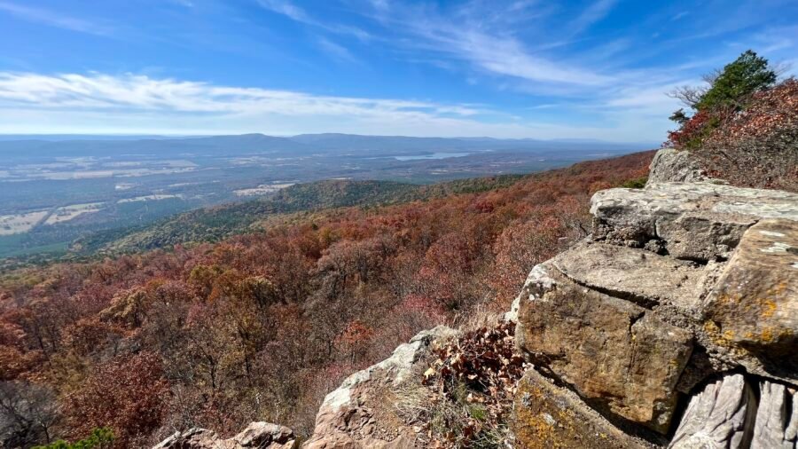
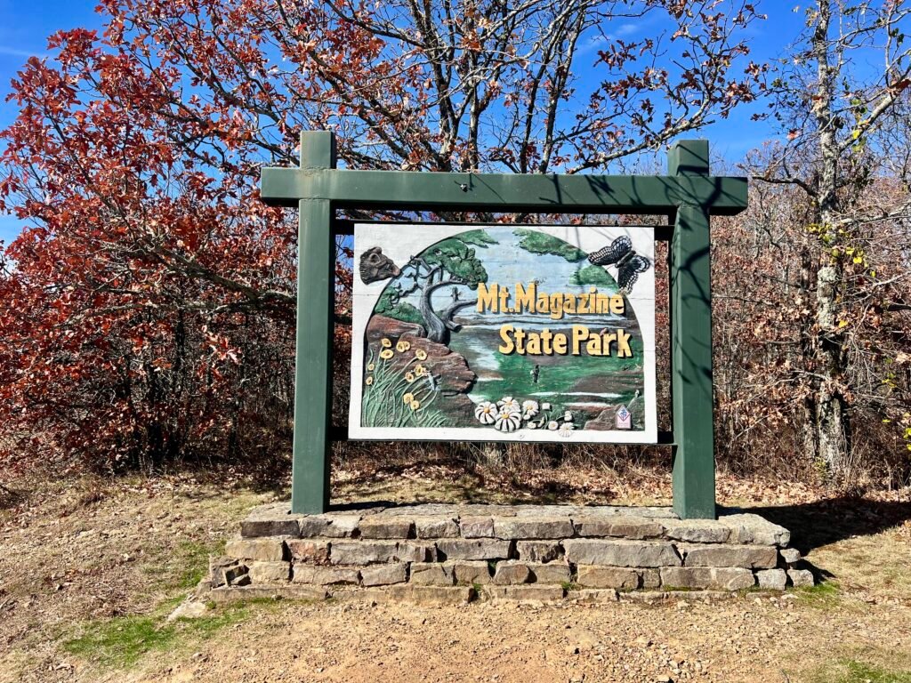
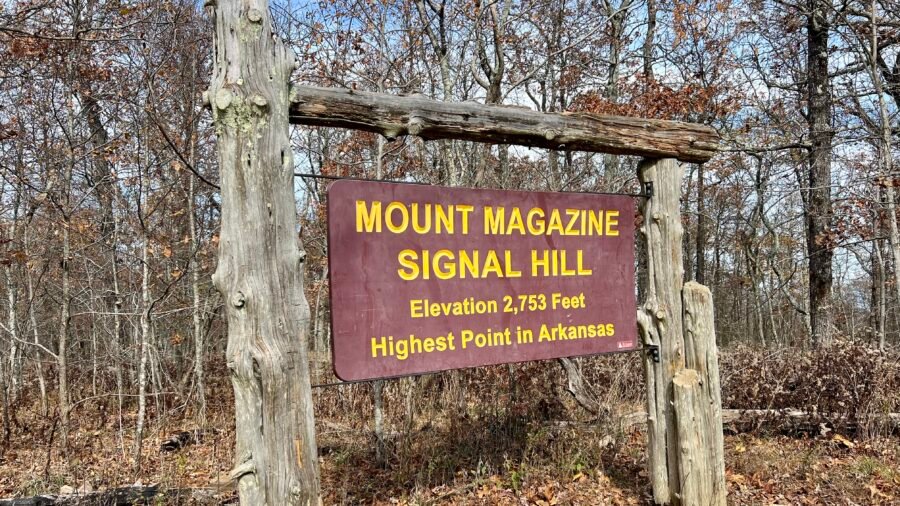
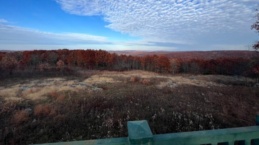
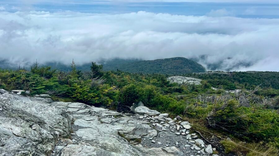
Since Mount Magazine and Signal Hill (the highest natural point in Arkansas) are both located within Mount Magazine State Park — which is on my list as the Best State Park in Arkansas — I decided to cover them together in one blog post.
Since Mount Magazine / Signal Hill sits inside Mount Magazine State Park — which is on my list as the Best State Park in Arkansas — I decided to combine both into one post.
The park is about 2 hours west/northwest of Little Rock, roughly 1 hour 15 minutes east of Fort Smith, and a little over 2 hours south of Bentonville — home of Walmart, for you trivia buffs.
Taum Sauk Mountain, located in the St. Francois Mountains of the Missouri Ozarks, is the highest natural point in the state. It stands at 1,772 feet, ranks #41 in State High Points, and was my 24th State High Point.
I sent a photo of me at the “summit” to my friend Pam, who’s originally from Joplin, Missouri. Her reply? “Fantastic!” Followed quickly by: “Had no idea MO had a high point! 🤣”
Honestly… fair.
It’s not exactly a dramatic summit. However, it is a beautiful state park, it’s outdoors, and it carries a surprisingly rich history.
Cape Henlopen State Park is a fascinating park, that offers so many different experiences and is worthy of visiting on multiple days. In fact, I would suggest using Lewes, Delaware or another nearby city as a vacation hub – Cape May, New Jersey (blog post coming soon) is a short ferry ride across the bay and Assateague State Park and Assateague Island National Seashore are about an hour away. There is so much to do in the area.
Picture: Park Entrance
A Guys Day
I specifically came to Lewes, Delaware to visit my friends Amanda and Phil. We all took the short trip to Assateague State Park and had a blast. However, on this day, Amanda had to work, so it was just Phil and I for a guy’s day out. That morning both Phil and I had a little work to finish before we headed out. I also made a little breakfast nosh, Smoked Salmon & Avocado Toast with Everything But the Bagel Seasoning. Delish! On the way to the park, we stopped by to see Amanda at the local Golf Club she bartends for a Bloody Mary. Let’s get this party started!
Picture: Smoked Salmon & Avocado Toast
About the Park
Cape Henlopen State Park, nestled on Delaware’s picturesque coast, offers a captivating blend of natural beauty and recreational opportunities. Spanning over 5,000 acres, this coastal gem boasts pristine beaches, rolling sand dunes, and lush maritime forests. Outdoor enthusiasts can explore a network of scenic trails, ideal for hiking and biking, while birdwatchers delight in the park’s diverse avian inhabitants.
History buffs can explore the iconic World War II observation towers that stand as silent sentinels along the shoreline. The park’s centerpiece, the historic Fort Miles, provides a fascinating glimpse into the region’s military past. Visitors can also indulge in water activities, from swimming in the Atlantic to fishing and kayaking in the park’s tidal salt marshes. With its rich ecological diversity and recreational charm, Cape Henlopen State Park beckons nature lovers and adventure seekers alike to discover the magic of Delaware’s coastal wonders.
Pictures: Park Maps were the focus of our visit, specifically the left-hand map.
Top 5 Activities
Explore the Beaches: Cape Henlopen State Park offers pristine beaches along the Atlantic Ocean. Visitors can relax on the sandy shores, swim in the refreshing waters, or engage in beachcombing and seashell collecting.
Hiking and Biking Trails: The park features an extensive network of scenic trails, including the popular Gordon’s Pond Trail and the Seaside Nature Trail. Hikers and bikers can immerse themselves in the park’s diverse landscapes, from coastal dunes to lush forests.
Visit Fort Miles: History enthusiasts can explore the historic Fort Miles, which played a crucial role in coastal defense during World War II. The fort features bunkers, observation towers, and informative exhibits, providing a fascinating glimpse into the area’s military history.
Birdwatching: Cape Henlopen is a haven for birdwatchers, offering diverse habitats for numerous bird species. Bring your binoculars and observe the variety of shorebirds, songbirds, and raptors that inhabit the park, especially during migratory seasons.
Water Activities: The park’s coastal location provides opportunities for various water activities. Fishing enthusiasts can try their luck from the fishing pier, and kayakers can explore the tidal salt marshes. The park’s natural beauty is best experienced from the water, adding an extra layer of adventure to your visit.
Reliving our Childhood
Both Phil and I grew up in an era of G.I. Joe and are both history buffs, so our first stop was Fort Miles. We had also visited Cape May, New Jersey the day before, where we initially learned about the observation towers and gun bunkers in the area. When visiting the park you have to go up into one of the Observation Towers. The observation towers have a rich history dating back to their construction during World War II when they served as lookout posts for coastal defense. These towers played a crucial role in monitoring the Delaware coast for potential enemy activity. Triangulation techniques were employed in their design, ensuring precise alignment and effective surveillance capabilities during their wartime function. Today, the observation towers are iconic landmarks, offering breathtaking panoramic views of the surrounding area.
Pictures: One of the Observation Towers | About the Observation Towers
Pictures: Spiral Staircase to the Top | Selfie on the Top of the Tower
Pictures: Views from the Observation Slots
Picture: View from the Observation Slots with the main gun battery
Battery 519
From the parking lot, it is a short walk to Battery 519, a 15,000-square-foot fortified underground chamber. Today, the main battery houses the Fort Miles Museum. Along the initial part of the walk, you’ll pass some of the original barracks and several of the weapons that were used to protect the fort and the coast. And of course, our inner childhood came out. . .
Pictures: The Barracks area and some of the weapons used to protect the fort.
Pictures: Boys will be Boys
As you walk up to the main bunker and Museum, you’ll see a couple of the guns used to protect the coast during WW II. The largest gun on display actually came from the USS Missouri, Mighty MO. This massive gun could shoot a 2700-pound shell over 20 miles with pinpoint accuracy. And you can see the damage such a shell can make on the thick steel of a Japanese ship during the war.
Pictures: Mighty Mo’s Big Gun | A shell and the type of damage it did to a Japanese ship
Picture: One of the guns used to protect the coast
Pictures: Fort Miles Museum
Pictures: Views from the Museum terrace
Beach Time
From Fort Miles, we continued our loop around the park and headed for the Senator David B. McBride Beach Bathhouse. It is a gorgeous facility with a boardwalk to the beach. I can only imagine how busy this place must be in the summer – remember our visit was at the beginning of November.
Pictures: McBride Beach Bathhouse | Boardwalk to the Beach
Pictures: Pillar on the Beach | Only the Shadows Know
Picture: The serenity of the beach
Birds of Prey
Right next to the Bathhouse area, you can spot the Cape Henlopen Hawk Watch Tower. This spot used to be a military bunker, but now it’s a great place to watch different types of raptors fly by. It’s pretty neat that they keep count of all the birds they’ve seen yesterday and overall. So if you’re interested in birdwatching, this is the perfect spot!
Pictures: The Bunker beneath the Hawk Watch | The Hawk Watch Tower
Pictures: Daily and To Date Raptor Sightings | View from the Hawk Watch Tower
The Point
Next up, my favorite part of the park – The Point. The beach was so chill and beautiful! We didn’t have enough time to check the whole thing out, though. Next time, I’d love to take a longer hike out to the point. We noticed a ton of horseshoe crab shells scattered around the beach. Later, we learned that the Delaware Bay and the area off of Cape Henlopen has the world’s largest spawning population of horseshoe crabs, which are the official State Marine Animal. They look like they’re straight out of the movie Predator, pretty cool! We also got to see a couple of other native crabs that were still alive.
Picture: The walk down to the beach from The Point parking lot
Pictures: A couple of the Horseshoe Crab shells
Pictures: Some of the other crabs we saw, per Google Lens – Lady Crab (r) and Ghost Crab (l)
Picture: Looking out to the Point
Last Stop – The Fishing Pier
The fishing pier at Cape Henlopen State Park offers a stunning view of the Delaware Bay, with sights of the Ferry port, The Point, a lighthouse, and Cape May, New Jersey. I met several fishermen on the pier who had caught Tautog or Blackfish that day, a fish species that is popular in chowders and similar to Red Snapper. I highly recommend a visit to Cape Henlopen State Park for a great day out!
Historic Downtown Lewes
After a long day, we hit up historic downtown Lewes for a refreshing libation and snack at the Pink Pony, the bar at Bramble & Brine at The Butttery. It’s a super cute bar with hundreds of equestrienne ribbons, and definitely worth checking out when you’re in Lewes.
Pictures: Historic Lewes, Delaware
Pictures: Bramble & Brine at The Buttery | The Pink Pony Bar and Equestrienne Ribbons
Pictures: Crab au Gratin | Older Old Fashion | Yumsies Humsies
I was in the Albany, New York area visiting family, and my sister, Vicki, and I decided to do a hike before we both headed back our separate ways. On a side note, I convinced Vicki to hike Mount Greylock, the highest point in Massachusetts and the first of my State High Points, during a trip to Massachusetts to see the incredible Sona Jobarteh in concert. The two of us have hiked many places together and this hike in John Boyd Thatcher State Park – commonly known as Thatcher State Park – was quite a fun and interesting find.
Brunch First, then Hiking
Our sister Melissa and her husband Richard also made the trip up to Albany as it was sort of a mini family reunion, actually a cousins reunion. After the reunion, and before we headed out, we went to The Scene Coffee and Cocktails in Albany, New York for brunch. It’s a super cute restaurant with a patio, complete with a Gelato Cart (although it was not open when we were there) and a Champagne Vending Machine. I thought the vending machine was super cool. You ordered and paid for everything at the counter, and if you ordered champagne, they gave you a special token for the vending machine. Unfortunately, no champagne today as we were heading out for a nice hike. The brunch sandwiches and coffee were delish and I would definitely recommend The Scene if you are in the area!
Pictures: The Scene – Albany | NY
Pictures: Gelato Cart | Champagne Vending Machine
Pictures: Uber Cute Coffee
Pictures: A couple of the delish Brunch Sandwiches
Off to Voorheesville
Thatcher Park is in Voorheesville, New York – that’s quite the name and no it’s not from a Dr. Seuss book. In the early 17th century, Dutch settlers established the colony of New Netherland, with Albany becoming a crucial trading post along the Hudson River. In 1899, Voorheesville was founded with its roots in the Albany and Susquehanna Railroad era, and it was named after Alonzo B. Voorhees, a railroad attorney. Over the years, it has evolved from a railway community to a charming village known for its historic buildings and community-oriented atmosphere.
About the Park
Thatcher State Park is a hidden gem for nature lovers and adventure seekers alike. Nestled in the scenic Helderberg Escarpment, this park offers a perfect blend of outdoor activities and breathtaking views. With over 2,000 acres of lush greenery, hiking enthusiasts can explore a network of trails that wind through wooded areas and lead to panoramic overlooks. The park has a $6 per vehicle fee, but my sister has an annual Empire Pass, so it’s included with the pass.
For those who prefer a more relaxed experience, the park provides spacious picnic areas, inviting families and friends to enjoy a sunny day outdoors. The park isn’t just about hiking and picnics; it boasts an awesome playground for kids and a refreshing pool to cool off during the summer months.
One of the highlights is the impressive Indian Ladder Trail, where you can walk along the cliff’s edge and take in the stunning vistas. If you’re lucky, you might even spot some soaring birds of prey. John Boyd Thatcher State Park isn’t just a park; it’s a nature-packed playground waiting to be explored. So, whether you’re up for a challenging hike, a leisurely picnic, or simply soaking in the scenic beauty, this park has something for everyone. Get ready to escape the hustle and bustle and immerse yourself in the tranquility of Thatcher State Park!
Pictures: Park Maps – for our hike, use the map on the left as a reference
What the heck is an Escarpment?
An escarpment is a steep, often cliff-like geological formation that marks the boundary between different elevations of terrain. Typically formed by erosion or tectonic activity, an escarpment creates a distinct and abrupt change in elevation. These formations are characterized by their steep slopes and can be found in various landscapes, offering stunning panoramic views from the elevated side while creating a notable transition between high and low areas.
Sounds like a cliff, so I asked ChatGPT what the difference was: While both cliffs and escarpments involve steep slopes, the key difference lies in their scale and geological context. A cliff is a vertical or near-vertical rock face with a considerable drop, often overlooking a body of water. In contrast, an escarpment is a more extensive and generally less steep slope that separates two different elevation levels in a landscape. Escarpments are larger geological formations, often marking the boundary between higher and lower terrains, whereas cliffs are more localized and frequently associated with coastlines. So there you have it!
Picture: About the Helderberg Escarpment
Top 5 Hiking Activities
Thatcher Park Overlook: One of the highlights of the park is the Thatcher Park Overlook, which provides breathtaking panoramic views of the Hudson Valley and the Adirondack Mountains. It’s a popular spot for visitors to take in the scenic beauty of the surrounding landscape.
Indian Ladder Trail: This trail takes hikers through a series of picturesque rock formations, caves, and waterfalls. The trail offers a unique perspective of the park’s geology and provides opportunities to explore the natural beauty of the area.
Hailes Cave: Hailes Cave is a fascinating limestone cave located within the park. While it may not be open to the public at all times, guided tours are sometimes available, allowing visitors to explore the cave’s unique features and learn about its geological significance.
Escarpment Trail: This challenging trail runs along the Helderberg Escarpment and offers stunning views of the Hudson Valley. Hikers can enjoy the diverse terrain, including rocky cliffs and wooded areas, as they traverse this scenic trail.
Thatcher Park Visitor Center: While not a hiking destination per se, the visitor center is a great starting point for exploring the park. It provides information about the park’s history, geology, and natural features. Additionally, it offers educational exhibits and interactive displays.
Our Visit:
We started at Thatcher Park Overlook, the first item on the list above, and it certainly delivers on the beautiful panoramic view. It is interesting, but understandable, that there is a parking time limit here. They are obviously trying to discourage hikers from parking here and wanting the spots to turnover for people coming here for the panoramic views.
Pictures: Panoramic Views from the Overlook
Picture: View from the Overlook, looking towards where we would park and start our hike
Parking time is up, time to find a parking spot
We decided to park near the Glen Doone Pavillion, the start/end of the Escarpment Trail. As a note, there is a restroom in this parking area. First, we headed to the point, which offers views of the valley below as well as the Overlook parking area. From here, you can see in the distance the other areas the trail will take you. The Escarpment Trail is 2.4 miles long (one-way) and is predominantly flat, so a relatively easy hike.
Pictures: Views from Glen Doone – Looking Back at the Overlook Parking Area | Valley Below
As you hike the Escarpment Trail towards the Visitor Center, you’ll hike through the Overlook Parking area again. Then as you round the bend at La Grange Bush, you’ll see another point and get a view of the Visitor Center.
Picture: View from La Grange Bush looking towards the Visitor Center.
Indian Ladder Trail
About halfway along the Escarpment Trail, just past La Grange Bush, you’ll come to the Indian Ladder Trail, 0.44 miles long. There is some elevation on this trail as you first descend a flight of stairs, then back up on the other side. However, I would HIGHLY recommend taking this trail. This trail will give you a close-up view of the cliffs as well as an opportunity to hike under the cliffs. But the best part of the trail – the two waterfalls that you pass under, first Minelot Falls, and then Outlet Creek Falls.
Pictures: Trail Under the Escarpment | Trail along the Escarpment
Pictures: Minelot Falls
Picture: Outlet Creek Falls
Pictures: Along the Indian Ladder Trail
As you ascend on the other side of the Indian Ladder Trail, you’ll come upon the Visitor Center and Thatcher Point. It’s a beautiful building with a spectacular view and a great place for events. The day we were there, they had just finished a wedding.
Picture: The Visitor CenterPicture: Vicki and Me along the Escarpment TrailPicture: View from Thatcher Point
The Squeeze Box
When we reached the end of the Escarpment Trail, we continued a little further and came across the Squeeze Box – the entrance to the Rock Climbing area. If you can’t fit through here, you won’t be able to fit through Helm’s Crevice, the access point to the Rock Climbing area. It’s tight as you can see!!!
Pictures: The Squeeze Box | Helm’s Crevice
Back to Glen Doone
At this point, we turned around and headed back to Glen Doone and our car. However, when we got to the Visitor Center and the Indian Ladder Trail, we continued along the ridge and on the Escarpment Trail. On this part of the trail, you cross the streams that become the waterfalls on the Indian Ladder Trail. It was a fun day of hiking and I would definitely recommend a visit to John Boyd Thatcher State Park! Bring a picnic and spend the day exploring the trails and enjoying the panoramic views.
I was well overdue on visiting Lewes, Delaware to see longtime friends Amanda and Phil, and when the opportunity came up, I immediately headed East. I mentioned that there were two parks I wanted to visit on the Discoverer’s List of the Best State Park in Each State. Amanda immediately jumped on the opportunity to visit Assateague State Park as it had been on her list of places to visit. With our cooler full and a beautiful day in the forecast, we headed south on the scenic Coast Highway to Maryland. The drive was just over an hour and as we drove through one town after another, I was amazed at the number of miniature golf courses along the way.
I’ve shared a bit about the park, ponies, and wildlife in the next sections. So feel free to skip through and jump to my notes about my visit and about Assateague National Seashore.
About the Park
Assateague State Park, Maryland’s only oceanfront park, is located on Maryland’s eastern shore and is known for its breathtaking coastal beauty and unique wildlife, particularly its famous wild ponies. These wild horses, known as Chincoteague Ponies, freely roam the park’s beaches, marshes, and woodlands, creating a distinctive and enchanting atmosphere for visitors. The ponies are believed to be descendants of shipwreck survivors and have adapted to the island’s dynamic ecosystem. Visitors can observe these majestic creatures in their natural habitat, providing a rare and memorable wildlife encounter. Assateague State Park spans 855 acres and offers a range of recreational activities, including camping, hiking trails, bird watching, and pristine sandy beaches for swimming and relaxation. The combination of natural beauty and the presence of these iconic wild ponies makes Assateague State Park a must-visit destination for nature enthusiasts and those seeking a unique connection with the untamed charm of coastal wilderness. Fees: Memorial Day weekend through Labor Day $5/person | After Labor Day to Memorial Day weekend $5/vehicle.
Picture: Entrance on Assateague Island
About the Ponies
There are two herds; one in Maryland and one in Virginia. There are approximately 78 in the Maryland herd and about 150 in the Virginia herd. A contraceptive darting program may be used with the Maryland horses to keep the population size to a sustainable number.
Local lore experts theorized the ponies arrived on the island via a shipwrecked vessel in the late 18th or early 19th century. Others attribute their arrival by pirates drawn to the island who ultimately abandoned the animals. A more likely theory is that farmers in colonial times used the island for grazing areas to avoid paying taxes on the land.
The National Park Service manages the herd of ponies at the northern end of Assateague Island. The separate herd in Virginia is owned by the Chincoteague Volunteer Fire Department, which sponsors the annual pony penning and swim every July.
The ponies’ diet consists mainly of marsh and dune grasses. Their water comes from the freshwater ponds located on the island. They are true horses, and not actual ponies, who have adapted to the diet and life on Assateague. During the winter their coats become quite thick to protect them from the harsh winds. Their short, stocky build allows them to navigate the marshes and to store water efficiently.
Other Wildlife
Assateague Island, situated on the Atlantic flyway, is a bird-watcher’s paradise. Over 200 species of birds have been sighted here, ranging from gulls to herons, egrets to eagles, and even rare peregrine falcons and snowy owls. The most commonly seen birds include ospreys, herons, egrets, sandpipers, shorebirds, ducks, geese, and other waterfowl. There are also two types of deer on the island, whitetail and sika.
The ocean and bay that surround the island are full of life. Dolphins can often be seen playing in the waves of the ocean. Flounder, spot, sea trout, puffer, rockfish, croaker, red drum, and bluefish are residents of the area, while marlin and tuna can be found in the deeper waters offshore. Occasionally, seals, whales, sand sharks, and sea turtles wash up on the shore.
My Visit to the Park
Our first stop before we crossed over to Assateague Island, we stopped at the Assateague Island Visitor Center, which is operated by the National Park Service (NPS). The visitor center has a lot of information about the history of and wildlife on the island, as well as a book and souvenir store shop. Assateague State Park encompasses only a small portion of the island, while Assateague Island National Seashore encompasses the majority of the island. Since this is operated by the NPS, we didn’t get much information about the park but did ask where there were pony sightings. The area around the visitor center offers some spectacular views of the Sinepuxent Bay.
Picture: Assateague Island Visitor Center
Pictures: Outdoor Map at the Visitor Center – if you zoom in on the picture to the left, you can see how small the State Park is relative to the Island.
Picture: Sinepuxent Bay
Let’s find some Ponies!
We headed across the Verrazano Bridge and over Sinepuxent Bay to the State Park and as soon as we got to Stephen Decatur Memorial Road, we saw our first ponies. We then continued straight and into Assateague State Park where we parked, paid our $5, and to our surprise, there was a lone horse just standing in the parking lot! The State Park has a beautiful beach, the 5 Tides Restaurant and Shop (which was closed for the season), and numerous camping sites. We headed to the beach to see if we could get a glimpse of the ponies on the beach, but there were none, just a bunch of surfers. We also walked along the road through the campgrounds (which was empty) in search of more ponies, but only found evidence of them in the form of Horse “Muffins.”
Picture: The lone pony in the parking lot.Picture: Assateague State Park Beach
Pictures: Beach Access from the Campgrounds | Horse “Muffins”
Picture: Campground with Bathroom and Shower Facilities
Ponies Sighting!
We decided to head out and see if we would have better luck at the Assateague Island National Seashore, so we headed back to the car and then south on Stephen Decatur Memorial Road. And to our surprise, as we left the parking lot, we saw the horse that was in the parking lot, now grazing by the roadside. Then as we turned left onto Stephen Decatur Memorial Road, we saw another pony!
Pictures: The Ponies!
Assateague Island National Seashore
As we approached the entrance to the National Seashore, there was a line of cars paying the entrance fee. I was a bit shocked at the cost of $25 per vehicle for 7 days (Although I swear it was $35). Anyway, I knew I was about to embark on a trip across the country, so I decided to renew my America the Beautiful Pass ($80 for the year), which gave us access to the park. I should note that if you arrive by foot or bicycle, there is no fee. Hint: Perhaps bring your bike, park at the state parking lot for $5, and ride your bike into the National Seashore.
Picture: Entrance to Assateague Island National Seashore
We decided to hike two trails while we were there – the Life of the Marsh Trail and the Life of the Forest Trail. The Life of the Marsh Trail takes you on an elevated boardwalk winding above the wetlands and mudflats and also takes you out to Sinepuxent Bay.
Picture: Sinepuxent Bay from Assateague Island
Pictures: Me, Amanda, and Phil | The Wetlands
We ran into a bunch of people during our hike and asked them if they had spotted any ponies. Then we got lucky – someone told us that there were several ponies on the Life of the Forest Trail! So we set off on our mission to see more ponies. The trail was a beautiful one that took us through the woods and eventually led us to a boardwalk with a view of a marshy area. Even though we didn’t spot any ponies on the trail as we had hoped, we did manage to see a few off in the distance. Our goal was still to see the ponies on the beach, so we moved on to the Life of the Dunes Trail. This trail took us through the dunes and along the beach. I was pretty sure that with all the trees and “hiding” places, we would definitely spot some ponies here – but no luck! We were still happy to have seen a couple of the ponies and decided to head out. But before we drove too far, we spotted another pony! With our day complete, we headed back north to grab a bite to eat. I enjoyed our trip to Assateague State Park and the Assateague Island National Seashore and would highly recommend it. On my next visit, I would spend more time on the beach relaxing.
Pictures: From the Life of the Forest Trail
Picture: The Beach from the Life of the Dunes TrailPicture: Our Final Pony Sighting
We had lunch in Selbyville, Delaware, just across the Maryland/Delaware border at Catch 54. My meal was a bit of a dichotomy – we all shared Crab Dip Loaded Tots and then I had the Roasted Beets with Pistachios, Grapefruit, Goat Cheese Mousse, and a Ginger Vinaigrette along with a refreshing Thompson Island IPA. Next up on my list to visit – Cape Henlopen State Park in Lewes, Delaware, and I also made a trip to Cape May, New Jersey.
In my previous post about Mount Mansfield, I mentioned that the weather was not ideal for camping, and hotel rooms were expensive. As a result, I decided to stay in a hostel named Round Hearth Cafe and Market in Stowe, which I booked through Airbnb. Christopher, the host, was extremely friendly and an excellent host at the cafe as well. Additionally, the stay included complimentary coffee and a discount on food at the cafe. The hostel is not luxurious and is mainly intended for skiers, as indicated by the industrial carpet in the hallways (suitable for ski boots and snow). The rooms are plain but comfortable, and the shared bathrooms are super clean and well-lit. Since it was the off-season, I felt like I had the entire place to myself.
Pictures: Entrance to the Cafe and Hostel | Outdoor Seating Area
Pictures: Stairway to Rooms | Upper Hallway
Pictures: Hostel Room | Men’s Bathroom
That night, I decided to check out the area and found the Idletyme Brewing Company which was just down the road. I hung out in the bar area and had a chat with some of the locals. We talked about what to order for dinner and what to see at Smugglers Notch State Park. But then, an ambulance went by and they told me something creepy – apparently, the locals think someone has fallen at Bingham Falls every time they hear an ambulance. On that happy note, I had a great time and the food was pretty good.
Pictures: Idletyme Brewing Co. | Doubletyme IPA 7% | Fish and Chips
Work First, then a Hike
The next morning I had to do some work for a client, so I had breakfast in the cafe downstairs and worked on my project. It took a bit of time to complete, but there was still some daylight and I decided to head to the dreaded Bingham Falls – only a 5-minute drive up Mountain Road to the Trailhead.
Pictures: The Double Diamond Breakfast Sandwich with Avocado and Home Fries | The Cafe Interior
Pictures: The Round Hearth | Round Hearth Cafe Interior
First, a little about the park
Nestled in the heart of Vermont, Smugglers Notch State Park is a nature lover’s paradise that seamlessly blends breathtaking landscapes with outdoor adventure. Spanning over 1,000 acres, the park is a haven for hikers, boasting an extensive trail network that caters to all skill levels. Towering cliffs and dense forests create a picturesque backdrop, offering a serene escape from the hustle and bustle of everyday life. The park’s crown jewel, the famed Smugglers Notch, is a scenic mountain pass that weaves through rugged terrain, providing an exhilarating journey for those seeking a challenge. Visitors can relish in the park’s rich history, discovering tales of smugglers who once navigated these hidden paths. Whether you’re a seasoned trekker or a casual stroller, Smugglers Notch State Park invites you to explore its vast beauty and uncover the secrets held within its sprawling expanse.
Pictures: Trail Map | Trail Descriptions
There’s a reason it’s called Smugglers Notch
In 1807, President Thomas Jefferson passed an embargo act forbidding American trade with Great Britain and Canada. This was a severe hardship for northern Vermonters since Montreal was closer than other markets in the US. Many local people continued illegal trade with Canada, herding cattle and carrying other goods through the Notch. Later, fugitive slaves used the Notch as an escape route to Canada. During the Prohibition years, liquor was smuggled from Canada over the improved road built in 1922.
Top 5 Things to See
Smugglers Notch: The iconic mountain pass itself is a must-see. Marvel at the breathtaking rock formations and immerse yourself in the rich history of the area, where 19th-century smugglers once navigated through this hidden gem.
This is not hard to miss as the road runs right through the notch.
Sterling Pond: Hike to the pristine Sterling Pond, the highest trout pond in Vermont. Surrounded by mountains, this alpine lake offers a serene setting for picnics and a chance to connect with nature.
Compete – more later in the post.
Bingham Falls: A natural wonder awaits at Bingham Falls. Cool off in the refreshing cascades and pools, surrounded by lush greenery. It’s a perfect spot for a rejuvenating dip after a day of hiking.
Despite the warnings – I checked this off the list.
Long Trail: Traverse a section of the famous Long Trail, which runs through the park. Whether you’re an avid hiker or a casual walker, the trail provides stunning views of the Green Mountains and an opportunity to explore the park’s diverse ecosystems.
Although I didn’t do the entire Long Trail, I did portions near the Chin (see my Mount Mansfield post) and near Sterling Pond.
Moss Glen Falls: A short drive from the park, Moss Glen Falls is a picturesque waterfall worth visiting. Surrounded by lush foliage, it’s a photogenic spot and a tranquil setting to appreciate Vermont’s natural beauty.
Not to be confused with the Moss Glen Falls near Hostel Tevere that I wrote about in my Mount Mansfield post. I didn’t go to this particular Moss Glen Falls.
Let’s Conquer the Falls!
With my work complete, I decided to get a late afternoon hike in and headed towards Bingham Falls. The falls are named after Hiram Bingham, an American missionary, explorer, politician, and early settler in the area. It was carved by glaciers during the last Ice Age and has been a local favorite for cooling off and unwinding for generations. The park has numerous educational signs and well-marked trails, including those at the falls.
Pictures: Some of the educational signs you’ll discover
From the parking lot off Mountain Road, the trail is just a short 0.8 miles out and back. There’s a bit of elevation change, with the biggest challenge being the descent to the base of the falls. It’s a beautiful walk through the forest, which leads to the Upper Falls area. From there, there are steps down to the base of the falls. As I explored the area, I realized why people often get hurt or even die here – the rocks are incredibly slippery and there are no fences to prevent accidents. Therefore, it’s important to take your surroundings seriously and be cautious. I can only imagine how many people have been injured while trying to take a “cool” pic for Instagram.
Pictures: The initial portion of the trail
Pictures: The Upper Falls area
Picture: The West Branch Little River flowing into Bingham Falls
Pictures: Upper Falls
Picture: Bingham Falls
Pictures: The steep and slick trail down to the base of the falls
Trail Therapy
As I headed back to the parking lot, I decided to take a hike along the river. While on the trail, my attention was drawn to a young woman seated by the riverbank, immersed in her thoughts with headphones on. Respecting her space, I continued cautiously. Eventually, reaching the trail’s end, I retraced my steps. This time, our eyes met, and she removed her headphones. Greetings were exchanged, and I sensed an unease. As we chatted, she confided in me about her health struggles, likely stemming from mold in her flood-affected apartment, a result of recent Vermont floods. With empathy, I shared some fatherly advice, ranging from seeking legal assistance to moving out or finding a roommate. Encouraging and positive, I ensured she felt supported before I left her. This situation echoed a moment near my sister’s home, where a stranger stopped, concerned about my well-being – not that I looked distraught – but due to a recent suicide at the nearby falls. Compassion is priceless, reminding us to be attuned to others and their experiences. I believe fate guided me on that trail, and I sincerely hope she found a solution to her challenges.
Boxed Wine, Cheese and Crackers
After an emotional finish to the day and having successfully survived the hike to Bingham Falls, I headed to the market to buy some cheese, crackers, and boxed wine for dinner. Yes, I am a fan of boxed wines and have found some really good ones. In fact, years ago, I went to an incredible restaurant in France that only served boxed wine. So, I set up a spot outside at one of the cafe’s outdoor tables and enjoyed the sunset before heading to bed as I had a big day of hiking ahead of me.
Hiking: Day 2
The next morning, I packed up and headed out for a day of hiking. I had hoped to get out early, but had to tend to some business before hiking as I knew cellphone coverage would be spotty in the mountains. With my business finished, I headed to the Smugglers Cave parking area where I would first head to Sterling Pond and then Smugglers Cave. For a Tuesday with overcast weather, the parking lot was filling up fast, but I was fortunate to get a spot. I stopped at the information booth and spoke with the volunteer about the trails and such. He was a super interesting guy who had been a ranger in the Adirondack Mountains.
Picture: Informational Sign at Smugglers Notch
Pictures: Boulders at the Parking Lot | Overcast Weather
A Steep Climb and Lookout for Bears
The trail up to Sterling Pond is a moderately challenging route – keep in mind you are hiking up a trail to a peak that people ski down. The Sterling Pond trailhead is across the street and the trail is 2.1 miles out and back to just Sterling Pond with an elevation gain of 1000 feet – with most of the gain at the beginning of the hike. And just like Bingham Falls, the rocks were wet and slick, lending to a slower-than-normal hike.
Pictures: Sterling Pond Trailhead
Pictures: The steep and slippery hike to Sterling Pond
Pictures: More of the steep incline | One of the “pop-up” waterfalls and streams along the trail
At the top of the mountain, you reach a portion of the Long Trail – the same Long Trail that connects the Chin to the Nose to the Forehead on Mount Mansfield. The entire Long Trail spans 272 miles from Massachusetts to the Canadian Border and was the first long-distance hiking trail in the U.S. Although this portion of the hike wasn’t too steep, it was sheer rock and super slick due to the wet weather.
Pictures: Joining the Long Trail | Warning Sign | Slick Rocks
I hiked up to Sterling Pond, which is the highest-elevation trout pond in Vermont. It was a peaceful and beautiful spot, that is until a loud family could be heard in the distance. I continued my hike around the pond. The loop trail is about 1.4 miles long and includes some narrow sections and a few inclines, but nothing too difficult to navigate. The beginning of the trail was a bit challenging because some parts had been washed out, but I managed to make my way through. At the top of the ski mountain, which was still wet and swampy from recent rains, I checked out the chair lift platform, which was pretty cool. The trail around the pond wasn’t always easy to follow, and I ended up wandering around the summit a bit until I found a clearing and the trail again.
Picture: Sterling Pond
Pictures: Washed out Trail | View of Sterling Pond
Pictures: Ski Trail Sign | Top of the Notch Lodge
Pictures: Chair Lift Platform | Where the trail continues – through the opening in the trees
Shortly after I re-entered the woods, I came across a picnic table and a couple enjoying their lunch. I think I startled them as there were few hikers in this area. From here I headed down the Elephant’s Head Trail and this is where things got a little interesting. To begin with, it was super quiet and I was the only person on the trail. Then the initial part of the trail, along Sterling Pond, is quite narrow and there are a series of small inclines and declines through narrow rock gorges. It wasn’t anything I couldn’t navigate, but challenging at a couple of points.
Pictures: Elephant’s Head Trail Marker | The “loud” family that was behind me – now off in the distance
Picture: Sterling Pond – from the other side
Pictures: One of the narrow gorges to maneuver through | The beauty of the forest
After you leave the area around the pond, there is another intersection and you continue on the Elephant’s Head Trail, which now takes you through the forest. From here it is an uphill climb, then back down. It was at this point that I began to see tracks in the mud. I had seen several dogs on the way up to Sterling Pond, but these were much bigger than the average dog. I suspected they were bear tracks! As a note: When I got back to the parking lot, I showed the ex-ranger and volunteer my photos of the tracks and he confirmed that they were bear tracks. I’m glad I was hiking with my bear spray! Eventually you connect back to the Long Trail.
Picture: Bear paw print in the mud
Pictures: Back to the Long Trail | The Long Trail – heading towards Sterling Pond Trail
Once I got back to the Sterling Pond Trail, I headed back down the mountain to the parking lot. Along the way, I ran into a guy who was taking pictures of birds. He said it was a quiet day and he hadn’t seen many birds, but what I thought was cool – he was there on his lunch break from work. How cool to have this in your backyard and hike on your lunch break!
Looking for Smugglers!
After returning to the parking lot, I unloaded my backpack and poles and took a break to eat and drink. The weather was improving and the area was getting busier with more cars waiting for parking spots. Once I finished my lunch, I went back to the information booth to ask about the bear tracks and to get more information about the Smugglers Cave. I was happy to find out that the cave was located right behind the booth and there was a short loop up and around the caves. The cave was quite interesting, and I could imagine smugglers hiding out there in the past. It was a great way to end my day. I am happy that I split my visit into two days, as there is so much to explore and enjoy at Smugglers Notch State Park! I would definitely recommend a visit to this beautiful park.
Pictures: To Smugglers Cave | The History of Smugglers Notch
Pictures: Smugglers Cave
Picture: Smugglers Notch
Time for a Beer
With the day relatively young, and Burlington, Vermont close by, I headed east to check out their craft brewing scene and to see a town I have been wanting to visit for some time. My first stop – Queen City Brewery – where I enjoyed a flight of beer and met a nice couple from the West Coast of Florida. We chatted about Florida Breweries and I mentioned my love for IPAs. They suggested I try Zero Gravity Brewery across the street as are known for their IPAs.
Pictures: Queen City Brewery
Pictures: Beers of the Day | My Flight of Beer
After finishing my flight, I headed across to the street to Zero Gravity Brewery where I picked up a few different IPAs in cans. With beers in hand, snacks in my cooler, and the golden hour approaching, I headed to nearby Oakledge Park to see the sunset on Lake Champlain. I sat on the rocks and watched an incredible sunset. It was a great way to end an incredible day!
Pictures: Waiting for Sunset | Ferry crossing Lake Champlain
At 4,393 feet, Mount Mansfield stands as the highest point in Vermont, ranking #26 among U.S. state high points and marking my 22nd summit. Known for its distinctive ridgeline—said to resemble a human face and aptly nicknamed “The Chin”—this Green Mountain icon had been on my list for a while.
From maple syrup to craft beer, covered bridges to ski slopes, Vermont has its vibe. However, this trip was about one thing: reaching the summit.
As I continue to visit the Discoverer’s List of Best State Parks in Each State, I am seeing some themes, but I also have started asking rangers and volunteers why they think their park is the best in their state. The Ranger at First Landing State Park thought for a minute and thought it was because of the diverse ecosystems in the park. I personally think it is because it is the most visited State Park in Virginia. So as I reflect on my visit, I did find the diverse ecosystems to be fascinating.
The parking fee is $7 and on weekends from April to October, it’s $10. As many of you know, I am not in favor of park fees, but at least this is by car and somewhat affordable for a family of $4 in one car. There are three different areas for the park – two entrances off of Shore Drive – to one side is First Landing Beach, the Visitor Center, and the Camp Grounds. On the other side is Cyprus Swamp Road, which will take you to the trail center. Additionally, there is an entrance of off Atlantic Avenue at 64th Street.
It was a hot and humid day, but thankfully it was overcast. It also looked like the weather was going to turn, so I did a drive-by at the beach area and focused my visit on the Trail Center area and then the area near the 64th Street Entrance.
Pictures: First Landing State Park – Beach
Pictures: Entrance Sign | Trail Map
About the Park and more work by the CCC
First Landing State Park, nestled along the shores of the Chesapeake Bay in Virginia, is a coastal haven that seamlessly blends natural beauty with historical significance. Spanning over 2,800 acres, this state park holds the distinction of being the site where English settlers, led by Captain John Smith, first touched the shores of the New World in 1607. The park’s name itself pays homage to this momentous event, marking the initial landing of these pioneers. Built in part by an all African-American Civilian Conservation Corps in 1933-1940, the park is a National Natural Landmark and is listed in the National Register of Historic Places.
As Virginia’s most-visited state park, it’s an oasis within urban Virginia Beach. The park has 20 miles of trails and 1.5 miles of sandy Chesapeake Bay beach frontage. First Landing offers many recreational and educational activities and has many unusual habitats including bald cypress swamps, lagoons and maritime forest, as well as rare plants and wildlife.
Camping enthusiasts can immerse themselves in the natural surroundings by staying at one of the park’s campgrounds, offering a unique opportunity to connect with nature. Educational programs and interpretive displays further enrich the visitor experience, shedding light on the region’s ecological and historical significance.
Please note: The park is located beside a military training center that operates year-round in any weather at any time of day or night. Park guests may experience unusual sights and loudness. Nighttime training may last even beyond midnight. The activities pose no risk to park guests.
Let the Hiking Begin
As you can see from the picture below, the trails in this park are well-marked. At the entrance of the Trail Center is a fox – a life-size, life-like bronze red fox created by Sculptor David Turner of Turner Sculpture on the Eastern Shore. Friends of First Landing State Park chose a fox for the sculpture because foxes are prevalent in the park and also because a fox is Virginia State Park’s mascot.
From the Trail Center parking lot, I decided to explore the swampy area first and take the Bald Cypress Trail. This hike takes you across a raised walkway through the trees and over the swamp. I did keep a keen out for snakes in the swamp, but didn’t see any, which I was super bummed about.
Pictures: “Fox on Alert” | Well Marked Trails
Pictures: Raised Walkway through the Swamp
Time for a Wardrobe Change
I hiked the Bald Cypress Trail which led me to the Cape Henry Trail. Then I reconnected with the Bald Cypress Trail and finally connected to the Fox Run Trail. As indicated by my previous sentences, many trails intersect each other near the Trail Center, making it a maze of trails. I walked a bit down the Fox Run Trail but soon realized I was uncomfortable. So, I turned back to the parking lot, changed my clothes, and grabbed a rain jacket along with some more water and snacks. After that, I restarted and walked again down the Fox Run Trail. Personally, I have no problem restarting a hike if I feel uncomfortable.
Fox Run connects to Long Creek Trail. This is a nice hike along Long Creek, although I was quickly reminded that I was in the middle of a city as I began to hear leaf blowers and the sound of hammers from a nearby construction site.
Pictures: Along Long Creek Trail
Mushrooms and Spanish Moss
While exploring the park, I discovered various mushrooms and Spanish moss. As a child, I was fascinated by Spanish moss and would look for it every year on our trip to Ormond Beach, Florida.
Pictures: Some of the many mushrooms I found in the park
Pictures: Spanish Moss
The Mystery of Unknown Waters
“The marsh, to him who enters it in a receptive mood, holds, besides mosquitoes and stagnation, melody, the mystery of unknown waters, and the sweetness of Nature undisturbed by man.” ― William Beebe, The Log of the Sun a Chronicle of Nature’s Year
The Long Trail passes through a cool marsh, filled with many hidden secrets beneath the unknown waters. Along the way, you will encounter observation towers that are perfect for bird watching and also witness the natural wonders of the area, such as crabs. The trail runs parallel to Broad Bay, where Long Creek flows in. And yes, bugs and mosquitoes are common in this area of the park.
Pictures: Looking out towards Broad Bay | The Marsh
Pictures: Observation Tower | Local Crab
Pictures: More of the Marsh
What do I hear in the distance?
While hiking on the Long Creek Trail, I heard a strange bird call in the distance. I decided to follow the Osprey Trail to investigate, and to my surprise, I discovered an Osprey perched on a dead tree. It seemed as though the bird was inviting me to come visit. The Osprey Trail has some uphill sections, as well as a stretch that runs along a beach and Broad Bay. As the trail moves away from the beach, you’ll cross a bridge and go over a tributary. The amber color of the water reminded me of Black Water Falls State Park in West Virginia where the water gets its amber color from the pine needles.
Pictures: The Osprey | Osprey Trail along the Beach
A lot of Backtracking Today
After crossing the bridge, I decided to turn around and head back up the hill. I took the Long Creek Trail to the White Hill Lake trail with the goal of reaching the “summit” of White Hill, which has an elevation of 33 feet. As I hiked up towards White Hill, I encountered a turtle crossing the trail. The turtle didn’t seem pleased to see me and quickly retreated into its shell.
Picture: The Turtle
A Great Place to Exercise
I didn’t take much time to reach White Hill. After that, I turned back and took the Long Creek Trail. I walked a short distance on the trail and later took the Kingfisher Trail, which led me to the Cape Henry Trail. The Cape Henry Trail is a mixed-use trail that caters to both hikers and mountain bikers. Along the way, there are various exercise stations, and I also passed several trail runners. I love trail running and would come here frequently for a run if I lived nearby.
Soon I was back to the Trail Center. I did a total of 6.5 miles, which took me 2 hrs. 30 minutes to complete. From here, I decided to drive to the 64th Street Entrance and explore that part of the park.
Pictures: One of the Education Signs | One of the Exercise Stations
Humans can be Horrible and Destructive
“It’s just a short drive to the 64th Street Entrance. This part of the park wasn’t very busy, though I think it would be if the weather were nicer. It began to sprinkle as I explored this section of the park. There is a cool beach to explore, as well as a maritime forest. The Narrows are also located here, which connects Linkhorn Bay with Broad Bay, and is filled with oysters as thick as stones. I ran into several families exploring the beach, as well as a few guys fishing. Unfortunately, my last impression of the park was an abundance of trash and graffiti on the trees. It’s sad to see how people can be so horrible and destructive.”
I was pleasantly surprised by First Landing State Park’s diverse ecosystems, historical significance, and recreational offerings. It’s a natural haven worth exploring, especially if you are vacationing in the area.
Pictures: The Beach at the 64th Street Entrance
Pictures: Some of the cool trees and wood along the beach
I had been to Myrtle Beach in the past year and to be honest it was not one of my favorite places. It should be with my Greek heritage and being a restauranteur – thanks to generations of Greek restaurateurs who set out to fill a need for vacationers, pancake houses abound in North Myrtle Beach. So when I saw Myrtle Beach State Park on the Discoverer’s List of The Best State Park in each State, I was a little skeptical, to say the least. I will have to say, that despite my skepticism, I was pleasantly surprised by my visit. So if you’re visiting Myrtle Beach, South Carolina – take time away from the souvenir shops, dinner theaters, attractions, and pancake houses, and make an effort to visit Myrtle Beach State Park. I would add that there is a fee to enter the park – and as many of you know, I believe in fairness, equality, and accessibility – consequently, I am against high entrance fees. One positive note on the fees, you can go in and out of the park on the same day – which was a benefit to me as you’ll see later on in this post. Here is the list of fees: $8 adults; $5/SC seniors (age 65 & older); $4/ child age 6-15; Free for children 5 and younger.
Pictures: Entrance on South Kings Highway | Park Map
About the Park and the CCC Strikes Again!
Myrtle Beach State Park, nestled along the stunning coastline of South Carolina, stands as a natural haven, offering a diverse range of attractions for nature enthusiasts and beachgoers alike. Spanning 312 acres, this coastal gem is a testament to the state’s commitment to preserving its natural beauty.
The park was developed by the Civilian Conservation Corps (CCC), a New Deal Program created by President Franklin D. Roosevelt. The program was designed to provide employment during the Great Depression while addressing national needs in conservation and recreation. I am finding this as a common theme in the Discoverer’s list and southern state parks.
One of the highlights of the park is its pristine beach that stretches for a mile along the Atlantic Ocean. Visitors can enjoy the sun, take a refreshing dip in the sea, or explore the shoreline for seashells and other marine treasures. The maritime forest, declared a Heritage Trust Site, showcases a unique ecosystem with a variety of indigenous plant and animal species. Hikers can explore the rich biodiversity of the forest through nature trails that wind through towering pines and myrtle bushes.
If you ever visit Myrtle Beach State Park, don’t forget to check out the Nature Center, which offers interactive exhibits and educational programs about the park’s ecology and wildlife. Unfortunately, the center was closed during my visit. You can also enjoy the park’s picnic areas and campgrounds, making it an excellent choice for a day trip or an extended outdoor adventure. The park is also renowned for its fantastic surf fishing spots, with stunning ocean views, and Myrtle Beach pier offers another great fishing location.
Pictures: The CCC and Myrtle Beach State Park | The Pier
Trip #1
Yes, I made two different trips to the park and was happy to learn they had in-and-out privileges. I did a little research about the park and came across this list of five things to do at the park. And the last item on the list piqued my interest.
TOP 5 THINGS TO DO
Enjoy an ice cream cone from the gift shop while taking a stroll out on the fishing pier.
Explore nature at the Nature Center or on a self-led scavenger hunt.
Hit the beach and search for shells, sea creatures and sharks’ teeth.
Escape the busy Grand Strand and enjoy a walk on the Sculptured Oak Nature Trail through the beautiful maritime forest.
Wake up early and relish in the peace and solitude of the park as you enjoy watching a sunrise.
Sunrise, here we come…
So early that morning, I got up and was happy the hotel had coffee ready. I grabbed two cups of coffee to go as I knew I would be gone for a bit and off I went. I was a little surprised that upon my arrival at the park, there was an attendant already there, collecting the entrance fee. I paid my $8 and in I went. I drove to the beach, parked my car and then found a spot on the beach to watch the sunrise. For the most part it was peaceful, but soon the “noise window” was open and planes began taking off from nearby Myrtle Beach International Airport. Nonetheless, I was happy to see the sunrise and had the beach nearly to myself.
Pictures: The many phases of sunrise
Pictures: The many phases of sunrise
Picture: The sun emerges
Pictures: Footprints in the sand | The many phases of sunrise
Pictures: And so the planes begin taking off | The raised walkway at sunrise
Pictures: One of the picnic areas | The pier at sunrise
Back to the Hotel
After enjoying the beautiful sunset, I went back to the hotel for the complimentary breakfast and to pack my things as I decided to head out to my next destination after I visited the park.
Myrtle Beach State Park, Round 2
On my second visit to the park, there were a few cars ahead of me at the entrance, but it wasn’t too bad. I parked my car near the fishing pier, as that was my next stop. As expected, the park was beginning to get busier. The pier provides great views of the beach and has a tackle shop, a gift shop, and an ice cream stand. A few people were fishing on the pier, but the end of the pier was closed due to some damage caused by a hurricane. As a result, some of the deeper fishing spots were unavailable. In addition, there were some oversized chairs that visitors could sit in and get a souvenir photo.
Pictures: Views from the pier
Pictures: Oversized chair | The Pier
Pictures: The closed portion of the pier | Swinging bench near the pier
Dressed to hike!
The trails are not very long, but I had read about the wildlife and decided to put on my hiking boots and bring my hiking poles. I did get a few looks from families – Like who is this guy? Doesn’t he know he’s at the beach? The park has copperhead snakes, and if you know anything about these snakes, you know why it is important to have poles and wear boots. Unlike other viperids, copperheads often “freeze” instead of slithering away, and as a result, many bites occur due to people unknowingly stepping on or near them. So off I went to the furthest trail – the Youpen Trail – named after an evergreen tree that can grow up to 30 feet tall – the Yaupon Holly (lex vomitoria). In the fall and winter, yaupon has bright red berries that are an important food source for birds and small mammals, and in the spring, yaupon develops pretty white flowers.
Pictures: Yaupon Trailhead | The Yaupon Trail
Be very, very careful….
Soon I came across three logs covered with mushrooms. And if you have read any of my earlier posts, you know I have a fascination with mushrooms. So I moved in to get a closer picture of the mushrooms, and then I saw it! A copperhead, “frozen” in the middle of the logs! I slowly moved away and made a note of the location so that I could let the rangers know. As an FYI – you can tell that it is a copperhead by the brown “Hershey’s Kisses” on the snake’s body.
Pictures: The 3 logs with the mushrooms and copperhead snake | The copperhead snake
More interesting wildlife…
Along the trails, I also saw a pink-striped oak worm moth (at least that is what both Google Lens and Apple Photo identified it as) and an American five-lined skink. The skink I had to go back and get the picture as it darted away the first time I was trying to get a picture. The trail eventually connects with the Sculptured Oak Nature Trail. I took this first to the left and to the “pond.” I am sure under all the fauna, there is a pond, but it was hard to see.
Pictures: Pink-striped oak worm moth | The Pond
Pictures: American Five-lined Skink | Another interesting mushroom
As you walk through the park, hopefully, you’ll be lucky enough to see the many blooming species of plants – such as the aquatic pickerelweed, hibiscus, and saltmarsh morning glory. Additionally, I came across the American Beautyberry and some cool trees.
Pictures: A fallen tree that I thought was super cool | American Beautyberry | Another cool tree
From the pond, I went back towards the beach on the Sculptured Oak Nature Trail. There are places on the trails to sit and enjoy nature, but something about sitting on a raised platform and knowing that there are snakes in the area, didn’t sit well for me – pardon the pun!
Pictures: Sculpture Oak Nature Trailhead | One of the benches to sit and enjoy nature| The Sculpture Oak Nature Trail
Picture: The Sculptured Oak
Completing the list
With items 3, 4, and 5 checked of the TOP 5 THINGS TO DO at Myrtle Beach State Park, I decided to reward myself with the first item on the list – enjoy an ice cream cone from the gift shop while taking a stroll out on the fishing pier. Espresso Chip please!
Picture: Espresso Chip Ice Cream Cone
The last item on the list was to visit the Nature Center. As it was on the way out, I decided to drive and park near the Nature Center. Additionally, the Park Office is across the street and I was able to let them know about the Copperhead Snake in the event they wanted to relocate the snake. After my report, I went to the Nature Center, but it was closed the day I was visiting. It wasn’t a total bust as I got to see a couple of Golden Silk Orbweaver Spiders.
Picture: Golden Silk Orbweaver Spider
I definitely made the most out of my visit to the park but will say that I don’t think I would make a special trip. However, if you are in the area, make an effort to visit the park, you’ll be happy you did!