Rattlesnakes, Regulations, and Ridiculously Good Views
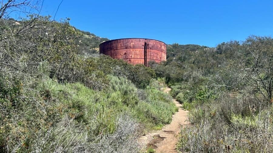
Catching up on some hikes from 2024, I found myself at Daley Ranch Park, a 3,201-acre conservation area in Escondido, California. I really didn’t know what to expect. I figured I’d get some miles in, gain a little elevation, and—hopefully—avoid the kind of crowded trails that tend to attract hikers lacking any semblance of trail etiquette. Normally, when I pull into a packed parking lot, my first instinct is to turn around and head somewhere quieter. But I stuck with my plan, and outside of a close encounter with a rattlesnake, Daley Ranch exceeded my expectations.
During a visit to Starved Rock State Park in Illinois, I struck up a conversation with a lively group of women on a girls’ trip from Wisconsin. They were seasoned adventurers, always seeking new outdoor escapades. Naturally, I offered to snap their picture, and in return, they shared a treasure trove of must-visit spots. One gem that caught my ear was Parfrey’s Glen State Natural Area. Imagine my surprise when I discovered that this secluded natural wonder is actually nestled within Wisconsin’s Devil’s Lake State Park, which happens to be my next destination—hailed as the best state park in Wisconsin by the Discoverer Blog.
Pictures: Entrance Sign off of County Road DL | Parking Lot
Helpful Hints
Wisconsin charges for entry to its state parks, and Devil’s Lake is one of the pricier ones at $16 per day for non-residents. However, you can snag an annual pass for $38, which is a better deal if you’re planning a longer stay. The only catch? The pass has to be attached to the inside of your windshield. Even though I was in a rental, I opted for the annual pass since I was staying for three days—$48 for daily fees versus $38 for the pass? No brainer!
Now, as you’re planning your visit, I wouldn’t recommend paying $16 just to see Parfrey’s Glen. It’s a nice spot, but not worth the fee on its own. If you’re visiting other parks in Wisconsin, it’s a great addition to your trip.
A Glimpse into History
Parfreys Glen, named after Robert Parfrey, a 19th-century settler who was among the first to appreciate its beauty, has long been a cherished destination for nature enthusiasts. The glen’s formation dates back to the last Ice Age, over 12,000 years ago, when glacial meltwater carved through the sandstone and quartzite, creating the narrow, steep-sided gorge that we see today. This geological marvel not only showcases stunning rock formations but also serves as a living testament to the Earth’s dynamic history. As Wisconsin’s first designated State Natural Area, this enchanting gorge offers a fascinating blend of history, adventure, and breathtaking scenery.
Pictures: Rock Rededicating the Park as a Natural Area
Peaceful Morning Hike
I spent the night in Middleton, Wisconsin (just outside Madison) and woke up early, ready for an adventure. Since I was ahead of schedule, I decided to check out Parfrey’s Glen for a morning hike. The trail is a manageable 1.7 miles round trip, perfect for a peaceful start to the day. The cool morning air and last night’s rain kept the bugs at bay, though they were starting to stir.
Parfrey’s Glen offers a relatively easy yet incredibly rewarding trail that takes you deep into a stunning gorge. The hike begins with a gentle stroll through lush woodlands, then gradually becomes more rugged as you get closer to the glen. Along the way, you’ll cross a creek multiple times and be surrounded by towering cliffs and vibrant, moss-covered boulders. The trail ends at a beautiful waterfall, where the soothing sound of cascading water invites you to pause, reflect, and enjoy the tranquil scenery.
My morning hike at Parfrey’s Glen was the perfect start to an adventurous day in Wisconsin!
Pictures: An Old Pitcher Pump | Trailhead Marker | Initial Part of the Trail
Pictures: Views along the hike
Pictures: The trail and one of the areas you cross the creek
Pictures: The beautiful walls of the gorge
Pictures: Close up view of the gorge walls
Picture: The waterfall at the end of the trail
Pictures: As I finished my hike, I saw a deer | The Ice Age Trail goes into Devil’s Lake State Park
One of my all-time favorite chefs and globetrotters was the legendary Anthony Bourdain. He once said, “Travel isn’t always pretty. It isn’t always comfortable. Sometimes it hurts, it even breaks your heart. But that’s okay. The journey changes you; it should change you. It leaves marks on your memory, on your consciousness, on your heart, and on your body. You take something with you. Hopefully, you leave something good behind.”
Now, let’s talk about Cape May, New Jersey. This little beach hamlet managed to break my heart in ways I didn’t see coming. Sure, the journey was fun and educational, but it was also like an unseasoned clam chowder – something was missing. Granted, I visited during the off-season, which meant fewer crowds but also fewer attractions. But honestly, after hearing my travel buddy’s tales of the summer madness in these beach towns, I’m pretty relieved I dodged the peak tourist frenzy. Cape May might not have lived up to the hype, but hey, at least I got a history lesson out of it!
Picture: Map of Cape May
When on Holiday. . .
A little background on this excursion – I was visiting my buddy Phil and his wife Amanda in Lewes, Delaware. With Amanda tied up at work, Phil and I seized the opportunity for a boys’ day out, setting our sights on Cape May. Our journey began at the Lewes Ferry Terminal, one of the nicest I’ve seen, and the On the Rocks Dockside Grill. Now, ferry protocol: arrive early, check in, line up the car, head inside to chill, and wait for the call. And since work was the last thing on our minds, we cozied up to the bar for some top-notch Bloody Marys because, hey, when on holiday, it’s practically the law! Here is a link to the Cape May – Lewes Ferry.
Pictures: The Lewes Ferry Terminal
Pictures: The Lewes Ferry Terminal | The Breakfast of Champions
The “Call”
It’s like the iconic moment at the Indy 500 when they holler, “Drivers, Start Your Engines!” But here, at the ferry terminal, it’s our turn. A crackle over the PA system signals it’s time to hustle to our cars and prepare to board. These salty sailors work their magic, seamlessly ushering vehicles onto the ferry. Once aboard, we ascended to the upper deck, ready to soak in the 85-minute voyage to Cape May. Despite the November chill nipping at our noses, we braved the brisk air for a while before retreating indoors to explore the ship and chill a bit more. I bet the trip in the summer is even more amazing. But, alas, we made do. And just like that, as the shoreline drew near, the call echoed once more, beckoning us back to our car for the next leg of our adventure.
Pictures: Boarded and set to go! | Looking back at Lewes
Pictures: Bundled up for the Crossing | Approaching the Cape May Ferry Terminal | Passing a Ferry
Farm-to-Bottle
Southern New Jersey boasts rich farmland, offering bountiful harvests of fresh produce. This fertile region is known for its vibrant, community-driven agricultural traditions. Here, farmers cultivate a bounty of crops, from juicy tomatoes to sweet corn, under the sun-drenched skies of the Garden State.
Our next stop was Nauti Spirits, a true farm-to-bottle operation, which is also one of NJ’s largest distilleries, with two massive all-copper pot stills and a column still. It is located on a bucolic 60-acre coastal working farm that sits between the Atlantic Ocean and Delaware Bay, less than 5 minutes from (and between) downtown Cape May and the Cape May – Lewes Ferry. The distillery is unique in NJ, as they use much of what they grow on their farm to produce their spirits.
Picture: Nauti Spirits Distillery
Pictures: Cool Vibe inside Nauti Spirts
Walking in, you’re hit with that vibe—cool, laid-back, and totally inviting. The staff? Top-notch. The place? Gorgeous, with sunflowers swaying in the breeze like a scene from a postcard. We sampled their spirits, and while they were good, let’s just say the bourbon left a little something to be desired for the price. But hey, it’s all about the experience, right? So we kicked back, sipping our cocktails, soaking in the vibe, and reveling in the beauty of local agriculture. Cheers to that!
Pictures: Sunflowers at Nauti Spirits | Bourbon on the Rocks and a Nauti Mule
Not So Lucky
Our stomachs growling, we decided to grab a bite before diving into our Cape May adventure. The chosen spot? Lucky Bones Back Water Grill. Not that it would matter to me (I’m a pescatarian), but with a name like Lucky Bones and the aroma of a pit barbecue as you stepped out of your car, you’d think the menu would scream BBQ. Spoiler alert: BBQ wasn’t the star of this show.
Curious about the quirky name, I found out that “Lucky Bone” refers to the peculiar hook-like claw of the male horseshoe crab. Back in Cape May’s whaling days, sailors deemed these claws lucky charms, taking them to sea for protection. Hence, the name “Lucky Bones.”
Pictures: The “Sargeant Joe Friday” Mahi Sandwich | Beer with more Personality
Back to our dining experience: we opted for bar seating, as the dining room felt like a relic from another era—eerily cavernous and devoid of charm. The menu? A nostalgic trip to the 1980s, alongside Banana Seat Bikes, Miami Vice suits, and leg warmers. The food was just okay—nothing disastrous, but certainly nothing to write home about. I ordered a Mahi sandwich with house-cut fries. Note to restaurant owners: if you’re going to boast about house-cut fries, make sure you know how to cook them properly! The sandwich itself was as bland and uninspired as Sergeant Joe Friday from Dragnet. At least the beer had a bit of personality, which was more than I could say for the rest of the meal.
A Step Back in Time
Cape May is home to one of the highest concentrations of Victorian homes (second only to San Francisco), drawing visitors from all over. We parked near the Washington Street Mall—a pedestrian promenade brimming with unique shops, quirky boutiques, a variety of restaurants, and laid-back bars. We decided to dive in and explore. The mall had some cool spots but didn’t quite blow us away, so we wandered into the Historic District. The tree-lined streets were dotted with Victorian homes, most of them impressively well-maintained. These ornate, colorful houses definitely added a touch of charm and old-world elegance to the area and I get why people are drawn here.
Picture: Victorian Home in Cape May | NJ
Picture: Victorian Homes in Cape May | NJ
Sun, Sand, and Surf
No visit to Cape May is complete without hitting its pristine beaches—though maybe when it’s a bit warmer! On Cape May Beach, we stumbled upon a quirky beach bunker, a World War II relic standing strong against time and tides. This concrete sentinel adds a dash of history to the sandy shore, perfect for snapping unique photos or pondering its storied past while soaking up the sun. We’d dive deeper into history the next day at Cape Henlopen State Park in Delaware, discovering how differently the two states approach these historic sites. Sorry Jersey, Delaware has you beat here.
Picture: Cape May Beach
Pictures: Cape May Bunker | Cape May Bunker and Lighthouse
Beacon of History
Our final pit stop: the Cape May Lighthouse, a beacon calling out to explorers like us. Built in 1859, this iconic landmark boasts a height of 157 feet and a staggering 199 steps to the top. Its guiding light once served as a vital navigational aid for ships sailing along the bustling East Coast. While we missed the chance to peek inside, its majestic presence alone was worth the visit.
Pictures: Two views of the Cape May Lighthouse
Pictures: From Cape May’s Maritime Past
Adventures in Okay
As Anthony Bourdain wisely said, “Travel isn’t always pretty…but that’s okay.” So, let’s talk about Cape May, New Jersey. Sure, it didn’t steal the show for me, but hey, that’s part of the adventure, right? From exploring quirky beach bunkers to tasting local spirits, it was a journey sprinkled with surprises and lessons learned. Each stop, whether stellar or just okay, added a new chapter to my story. And isn’t that what travel’s all about? Happy Travels!
Hiking the Elfin Forest: A Day of Adventure and Nature Wonders
If you’re craving an adventure that blends nature’s beauty with a solid workout, hiking at Elfin Forest Recreational Reserve is a must. On my most recent hike, I made my way up the Botanical Trail, transitioned to the Way Up Trail, looped toward the Lake Hodges Overlook, and then descended back down the Way Up Trail. Altogether, it’s a route that delivers steady elevation, wide-open views, and just enough challenge to feel earned.
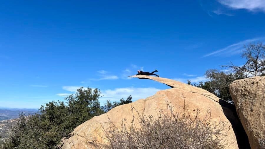
Some places become famous quietly. Others explode thanks to Instagram, hashtags, and gravity-defying photos. Potato Chip Rock is firmly in the second category.
Normally, I avoid viral trail spots like the plague. Between the wannabe influencers, endless selfies, and people blocking narrow trails for “just one more shot,” it can feel like more work than fun. But every once in a while, curiosity wins. And honestly? This one earned its hype.
Add in the fact that it’s a legit cardio workout, and suddenly I was in. So yes — I did take that photo on Potato Chip Rock. No, it never made it to Instagram.
As I headed westward from Louisiana to San Diego, I stopped at Lake Murray State Park in Ardmore, Oklahoma. I went via Dallas, Texas, and didn’t even recognize the city I used to live in. From the explosive growth came a concrete jungle with highway interchanges as tall as skyscrapers and strip malls covering every inch of land from Dallas to to Denton – some 40 miles. Lake Murray State Park is located about 1/2 way between Dallas, Texas, and Oklahoma City, Oklahoma, just off Interstate 35 and about 10 minutes from the center of Ardmore, Oklahoma.
Picture: Northern Park Entrance at US-70 and Route 77S
About the Park
Named after Oklahoma Gov. William “Alfalfa Bill” Murray, Lake Murray State Park comprises a 12,496-acre recreational area and a 5,728-acre, man-made lake created by the damming of the Fourche Maline and Anadarche creeks. Lake Murray’s crystal-clear spring-fed waters and 150 miles of shoreline welcome a variety of outdoor recreation opportunities including hiking, biking, boating, fishing, and camping. There is a $10 fee per day to park anywhere in the park that you pay through an app or you can pay cash at the park office. You’ll see signs at every parking lot, but only need to pay once per day.
Lake Murray State Park is the first and largest state park in Oklahoma and was constructed during the era of Pres. Franklin Roosevelt’s New Deal and part of several New Deal Agencies including the Civilian Conservation Corp or CCC, which I have written about in my past blogs about other state parks; and the Works Progress Administration or WPA. The solons envisioned the park as a relatively cheap recreational environment for the citizens of Oklahoma (I beg to differ with a $10 parking fee). Two main group camps were created, along with a “Negro” camp. Lake Murray State Park became the only state park built by the National Park Service to provide permanent camping facilities for black youth.
Staying at the park is easy with your choice between RV and tent campgrounds, 56 cabins dotted throughout beautiful Lake Murray State Park, and The Lake Murray Lodge with 32 rooms. The Lodge has a restaurant, an outdoor pool, a splash pad area, and a miniature golf course.
Pictures: Northern Park Map | Southern Park Map
Top 5 Activities at Lake Murray State Park
Lake Murray State Park is definitely a destination for boating and water activities, as well as camping. My impression was that it’s more of a “resort” and not the woodsy, outdoors, and rustic parks that I personally prefer to visit. This particular list of activities is ranked in what I feel are the common uses for the park.
Boating and Water Activities: Lake Murray is a large reservoir, and visitors can enjoy boating, fishing, swimming, and other water activities. The park has boat ramps, a marina, and designated swimming areas.
Camping: For those looking to extend their stay, Lake Murray State Park offers camping facilities. Whether you prefer tent camping or RV camping, there are options available within the park.
Golfing: Lake Murray State Park features an 18-hole golf course known as the Lake Murray State Park Golf Course. Golf enthusiasts can enjoy a round of golf surrounded by the park’s picturesque scenery.
Visit the Tucker Tower Nature Center: Tucker Tower is a historic structure located within the park that now serves as a nature center. It was originally designed to be a summer home for the governors of Oklahoma and today it is the home of the Nature Center and providing educational exhibits about the area’s natural history and offering panoramic views of Lake Murray.
Hiking and Nature Trails: Explore the natural beauty of the park by taking advantage of its hiking and nature trails, which span over 30 miles in total. These trails offer a chance to see local wildlife and enjoy scenic views of the lake and surrounding landscapes.
Let the Driving Tour Begin!
I spoke with the receptionist at my hotel in Ardmore and she gave me some good recommendations on the sights to see which included the Fishing Pier and Tucker Tower, but added that Tucker Tower was currently closed for repairs. After breakfast, I headed out to the park, entering from the north entrance by the Lake Country Store, then taking Route 77S, the scenic highway around the park and lake. I did find it odd that the speed limit on 77S is 45 mph, which I thought was fast and not conducive to enjoying your drive around the park.
Before I continue, I wanted to give you some background and context on my visit. I felt as if Lake Murray State Park is best explored if you are staying there for a couple of days, which I did not do. I also think having access to a boat is key to fully enjoying the park, which I did not have. I personally love hiking, and to be frank, outside of my jaunt to Buzzards Roost, I didn’t find the trails very interesting. I also think that because my visit was in November, there wasn’t a lot open at the park and it lacked energy from having people around. So hopefully that will help if you are looking to visit the park.
With that said, I first stopped at the Pecan Grove Picnic Area, and yes, you have to pay to park here. It is a typical picnic area and there is a trail that you can take back north to the Lake Country Store and along the lake.
Pictures: Pecan Grove Picnic Area
Pictures: The trail at Pecan Grove Picnic area
Next up was the North Boat Ramp, where you get your first view of the lake. I had to laugh as I pulled into the parking area and saw a parking enforcement officer in his car, which I certainly didn’t expect to see, especially on a quiet Monday. So I guess they take their parking fee seriously.
As I continued south, Dukes Forest Campground was next, but it was closed for the season. Shortly after this, there is a small parking area and the Johnson Memorial Bridge, an arched bridge named in honor of E.J. Johnson, project superintendent for the CCC work projects here at Lake Murray.
Pictures: Memorial Bridge | Large Boulder by the Bridge | Plaque about the Bridge
Next, I took Gatehouse Road towards the lake, which will take you to several camping areas and sights – Elephant Rock Camp, Cedar Point Camp, and Tipp’s Point Boar Launch. Gatehouse Road also dead ends into a parking lot with a view of the lake. As I drove through this area, I saw the only wildlife on my tour, some deer.
Pictures: Lake Murray from Elephant Rock Campground
The Lake Murray Lodge
Lodge Road, the western park entrance, is next on the tour. At the intersection of Route 77S and Lodge Road is one of the Park Offices, which to my surprise was closed. As you drive towards the lake, you’ll first pass some of the park’s cabins and then you’ll arrive at The Lake Murray Lodge – home to an outdoor pool, miniature golf, and a water sports rental center. There are also floating cabins nearby. As you leave the area, you’ll pass the Historic Water Tower, vital to the park’s cabins and lodge during their initial years of operation.
Pictures: One of the Cabins | The Lodge’s Outdoor Pool
Pictures: Miniature Golf Course | Water Sports Rental Center
Pictures: Lake Murray Lodge
Pictures: The Historic Water Tower
Some of the Water Activities
The Fishing Pier, recommended by the hotel receptionist, is right after the Lodge Area. For the record and as I know it, a pier is built out into the water, while a bridge crosses the water from shore to shore. Sorry State of Oklahoma, this is a bridge and not a pier. I walked across the “pier” as I wanted to hike some of the trails in the park, only to find a yellow stake in the ground, a trail guide of sorts, that was hardly legible and written with a Sharpie. Really?!
I ended up hiking about 1/4 mile and as I was unsure where the trail went, I turned back and went up another trail along the water’s edge. From here I got a nice view of the “pier” and the cove. This trail wasn’t well marked, so I turned around and headed back to my car. On my way, I ran into a woman with a strong accent, either Eastern European or German, walking her dogs. She stopped me to see if I knew about the trails and where this trail went. I told her that the Park Office was closed and I wasn’t able to get a trail map. With that she pulled out the maps she got from the Park Office – they were detailed topographic maps, that were so small you needed a magnifying glass to read, and so detailed you needed a PhD in Rocket Science to decipher them. I think the State needs to hire me as a Park Consultant.
Pictures: Sign at the Parking Lot | The Fishing “Pier”
Pictures: Trail Guide? | View of the Cove and Lake
Picture: The Fishing “Pier”
The Marina
Lake Murray Marina currently features 352 boat slips which should not be a surprise as boating is probably the number one feature of the park. The marina is accessible from Boat Dock Road and a portion of it is accessible from Buzzards Roost. For those wanting to just enjoy the water, there is the Lake Murray Marina Beach. From the marina, you also get a direct view of Tucker Tower Nature Center. This happened to be my only view of the infamous Tower as the road to the tower was closed on the day of my visit.
Pictures: The Marina
Pictures: My only view of Tucker Tower | The Entrance to Tucker Tower Nature Center
Picture: Tucker Tower Nature Center with the Marina in the background
The Best for Last
Buzzards Roost Road ends on the south side of the Marina. Along this road, you’ll see one of the original CCC Picnic Pavillions, constructed of large timbers and native stones. Next to the Buzzards Roost Campground, there is a small parking lot and the remnants of a cabin or building. To the right of the building is a set of stone stairs that will take you up to the Roost. Once on top, you can hike to either the left or right. I went in both directions and eventually found openings in the rocks where I had the most incredible and magnificent views of the lake and surrounding area. You can tell hiking, especially up and through rocks, is my jam!
Pictures: CCC Picnic Pavillion
Pictures: Building Remnants
Pictures: Some of the Stairs to the Roost
Pictures: Trail along the Roost | Selfie on the Roost
Picture: View from the Roost
Pictures: Views from the Roost
I finished my tour with a stop to get a view of the lake from a higher elevation, then a stop at Rock Tower. Overall it was a nice and interesting park that I would probably visit if I lived in the area, but I certainly wouldn’t list it as a destination park or a park I would make a special trip to.