About Taum Sauk Mountain
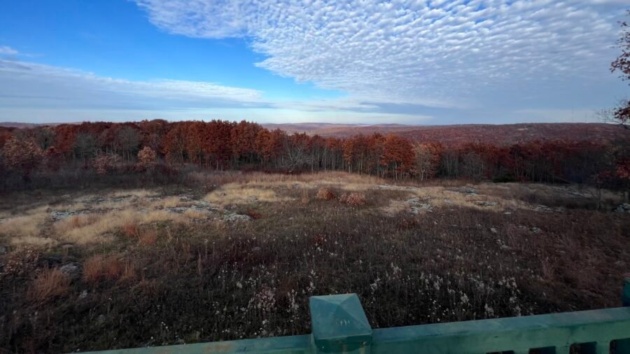
Taum Sauk Mountain, located in the St. Francois Mountains of the Missouri Ozarks, is the highest peak in the state. It stands at an elevation of 1,772 feet (540 meters), ranks #41 in State High Points, and was my 24th State High Point. I sent a picture of me at the “summit” to my friend Pam, who is originally from Joplin, Missouri, and she replied “Fantastic!”, then followed by “Had no idea MO had a high point! 🤣” Yeah, to be honest, it isn’t much of a high point, but it’s a park, outdoors, and an interesting history.
The mountain is part of the Taum Sauk Mountain State Park, which encompasses 7500 acres including rugged terrain, dense forests, and the iconic Mina Sauk Falls, Missouri’s tallest waterfall. The mountain and park are located about 100 miles or 1 hr. 45 minutes south of St. Louis. Hiking trails, including the Taum Sauk Section of the Ozark Trail, wind through the rugged landscape, providing opportunities for outdoor activities such as backpacking and camping. The mountain is part of the Taum Sauk section of the Mark Twain National Forest, ensuring its preservation and accessibility for future generations.


Pictures: Park Entrance | Trail Map – Note: The High Point is in the upper right corner
Missouri’s Romeo & Juliet
I came across some fascinating information and theories while researching Taum Sauk Mountain and the origin of its name. Taum Sauk is purportedly named after a Pianskeshaw chief named Sauk-Ton-Qua, and is associated with his family tale, which is often described as Missouri’s version of Romeo and Juliet. But instead of star-crossed lovers from dueling families, the Indian legend features star-crossed lovers from warring tribes. Sauk-Ton-Qua’s daughter, Mina Sauk, fell in love with a warrior from a hostile tribe. When the chief killed his daughter’s lover by throwing him off of a nearby cliff, Mina followed him over the edge. This incurred the wrath of the mythical Storm King, summoning a hurricane to wipe out Sauk-Ton-Qua’s entire tribe. A lightning bolt struck the ground and caused a waterfall to appear, wiping away the blood of the lovers. Today that falls are known as Mina Sauk Falls.
This Native American legend was retold many times among settlers in the region, but the name Sauk-Ton-Qua was difficult for some of the newcomers to pronounce. Therefore, they decided to alter the chief’s name from Sauk-Ton-Qua to ‘Taum Sauk’ instead.
My Visit to Taum Sauk Mountain:
After leaving St. Louis and heading south, I followed Missouri 21 until I reached Missouri Highway CC. This road is paved until the Lookout Tower, with the last 8/10 of a mile being a dirt road to the trailhead parking lot. Once on the dirt road, you’ll pass by The Overlook on your right, which is the only real viewpoint from the mountain. Shortly after The Overlook, you’ll reach a relatively small parking lot.


Pictures: The last 8/10 of a mile – a dirt road | The Overlook

I got to the parking lot in the late afternoon and knowing that it was a short distance to the summit, and later much to my dismay, I didn’t prepare for a long hike. The hike to the high point is an exhausting 0.4 miles out and back. lol All joking aside, what I really liked about this high point was that it was super easy to get to because of the paved path leading up to it. As I was leaving the area, I bumped into a small group and one of the guys was in a wheelchair. I know that not all high points can be made wheelchair accessible, but it was pretty cool that this one was. There isn’t much at the summit area – a marker, a bench and box with a sign-in log book.


Pictures: Parking Lot Area | Parking Lot


Pictures: Trailhead | Paved Path to the High Point


Pictures: High Point Marker | Sign-In Log Book | Summit Selfie
My Disappointment
I decided to hike to Mina Sauk Falls – the trail is just off the path to the High Point. But the trail was rocky, and I wasn’t wearing the right footwear, which made it challenging to move quickly. I wanted to get to the falls fast because it was getting late and the temperature was dropping. Unfortunately, I had no supplies, including water, snacks, and a headlamp. After hiking about a quarter of the way, I decided to turn back and return to the car. Even though I passed several groups of people who were headed to the falls, I felt it was best not to push it. I hope to come back again and spend more time at the park. Maybe when I visit Lake of the Ozarks State Park, which is on my list as the Best State Park in Missouri and about a 3.5-hour drive away, I’ll make the journey back here. I am sure it’ll be worth the trip if I’m in the state.

On the way out, I decided to stop at the Lookout Tower. If you have read any of my previous posts, you know that I have passed on going up to the top of several of these towers due to my fear of heights. So, with renewed energy, I decided to conquer my fears, or not! I got up a 1/4 of the way and turned back. My second disappointment for the day – oh well. Maybe one of these days, I’ll conquer that fear!


Pictures: Trailhead to Mina Sauk Falls | Trail to Mina Sauk Falls

Date of Visit: 11 November 2023
