Some places never lose their magic — no matter how many times you return. Torrey Pines State Natural Reserve is one of those rare spots. Perched above the Pacific in La Jolla, it’s a dramatic mix of rugged cliffs, rare pine trees, and golden beaches that somehow feels wild and refined at the same time.
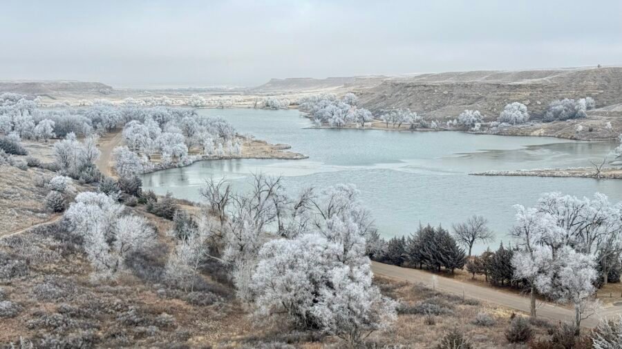
Happy 2025! After a fun New Year’s Eve in Nashville — raving to Sofia Kourtesis at Night We Met — I decided to kick off the year with something equally energizing: exploring, hiking, and high-pointing. If you’re going to start a new year, why not begin on a literal and figurative high note? Historic Lake Scott made for the perfect start to 2025.
So far, I’ve visited 32 of the 50 Best State Parks in the U.S. (as ranked by The Discoverer). I’ve also stood atop 32 of the 51 State High Points — yes, including Washington, D.C., because why not? That leaves some serious ground to cover.
After the high of conquering Eagle Mountain and exploring Grand Marais, it was time to return to Tettegouche State Park and settle into my new campsite. The drive back along Minnesota’s North Shore was a scenic hour, and before heading in, I swung by the visitor center to officially check back in (see Part 1 of my adventure here).
This new site, tucked deeper into the Baptism River Campground, immediately impressed me. The layout here is top-notch — each campsite has breathing room, which means you’re not cheek-to-cheek with your neighbors. That said, there was one guy with a generator humming in the distance. I thought most of these sites had electricity? Maybe he missed the memo.
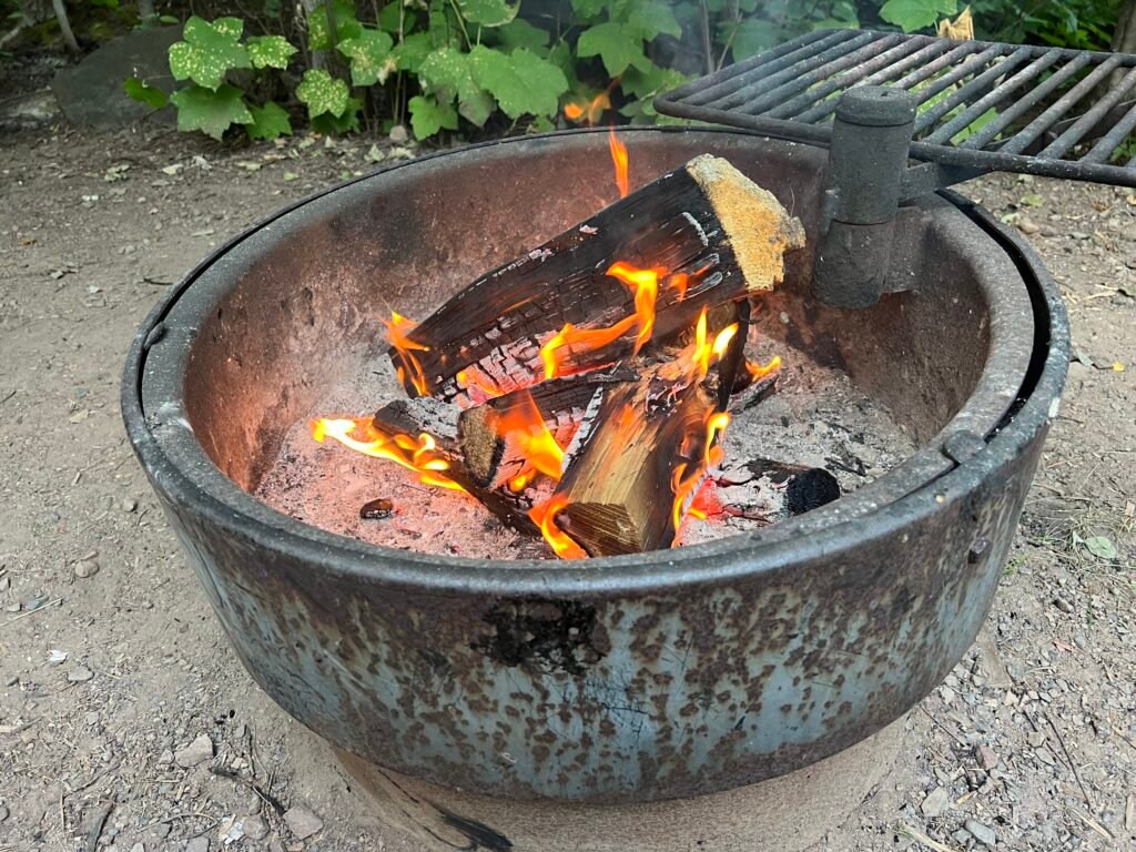
As evening settled in, I built a roaring fire, poured a glass of red wine, and pulled out one of my reliable camping staples: Yellow Tadka Dal from Trader Joe’s paired with Earthly Grains Basmati Rice from Aldi. Shelf-stable, easy, and surprisingly satisfying. Even better, I cooked it in my trusty cast iron skillet — which, frankly, is a miracle I managed to wedge into my suitcase.
Photo: Fireside Bliss Under the Evening Sky
Morning Visitor: The Hare-Raising Encounter
Up and at it early — again.
I started the morning with cold brew coffee and a splash of Coffee Mate (not ideal, but it lasts longer than real half-and-half in the wild). While soaking in the stillness along the Baptism River, I had a surprise visitor: a snowshoe harecasually hopping through camp.
Here’s the fun part — in Minnesota, these hares are dark brown in summer. However, when winter arrives, their coats turn snowy white in a seasonal shift known as leucism. Nature’s wardrobe change at its finest.
Photo: My Morning Visitor
Two Waterfalls, Twice the Fun
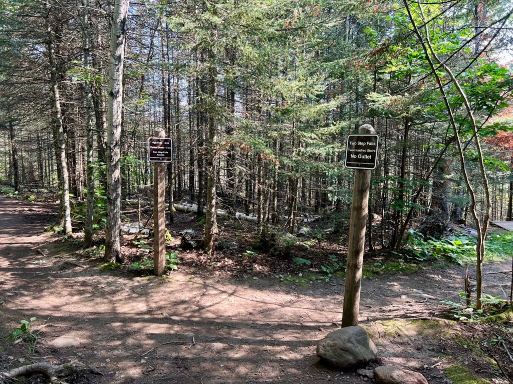
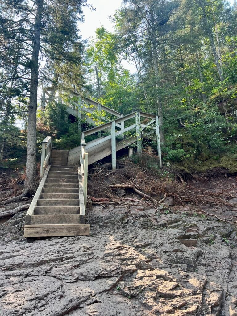
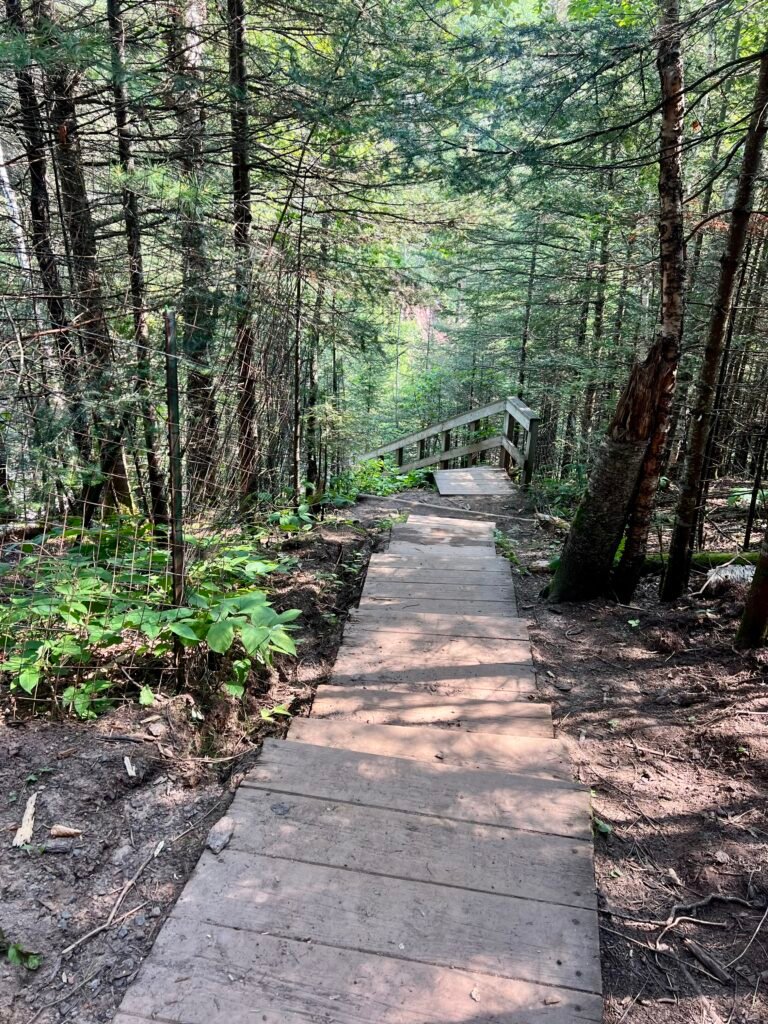
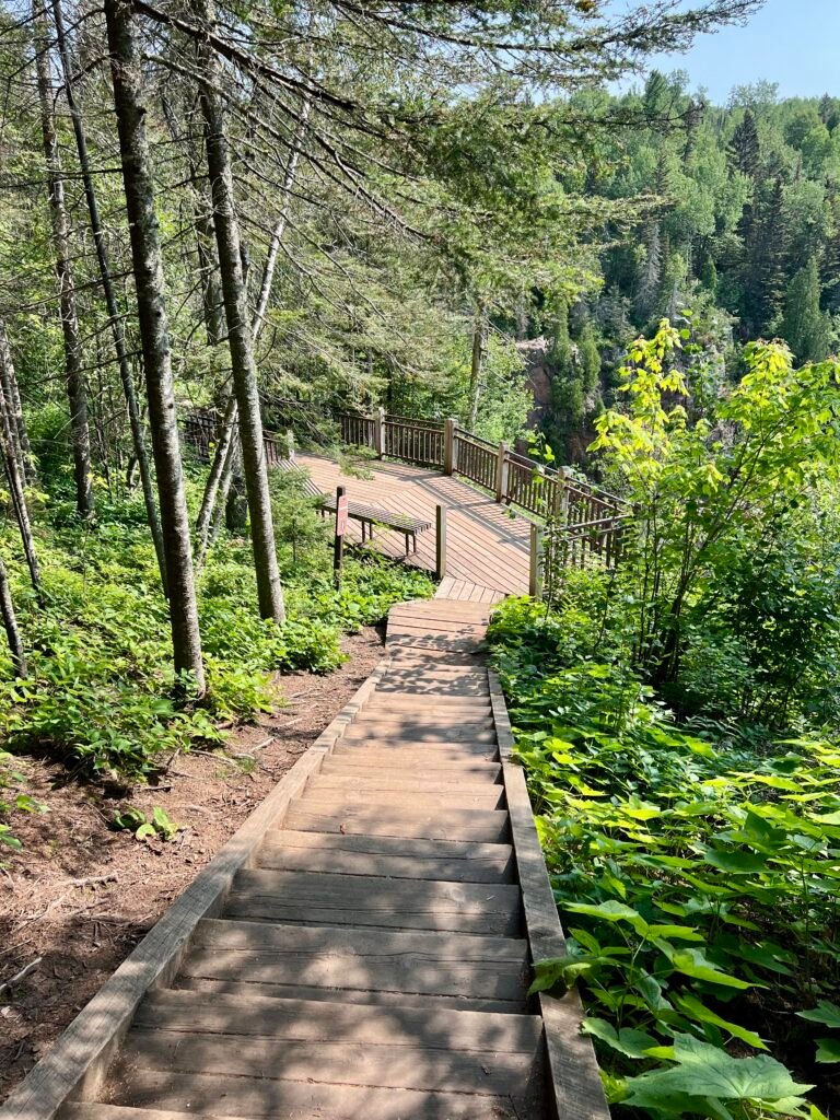
With clear blue skies overhead, I set out to revisit Two Step Falls and High Falls — this time from the opposite side of the river. The trailhead near Baptism River Campground offers a completely different perspective, and because of that, it felt like an entirely new experience.
I began with Two Step Falls, which requires a 200-step descent. In other words, you earn this view.
Photos: The Trail and the Stairway to Two Step Falls
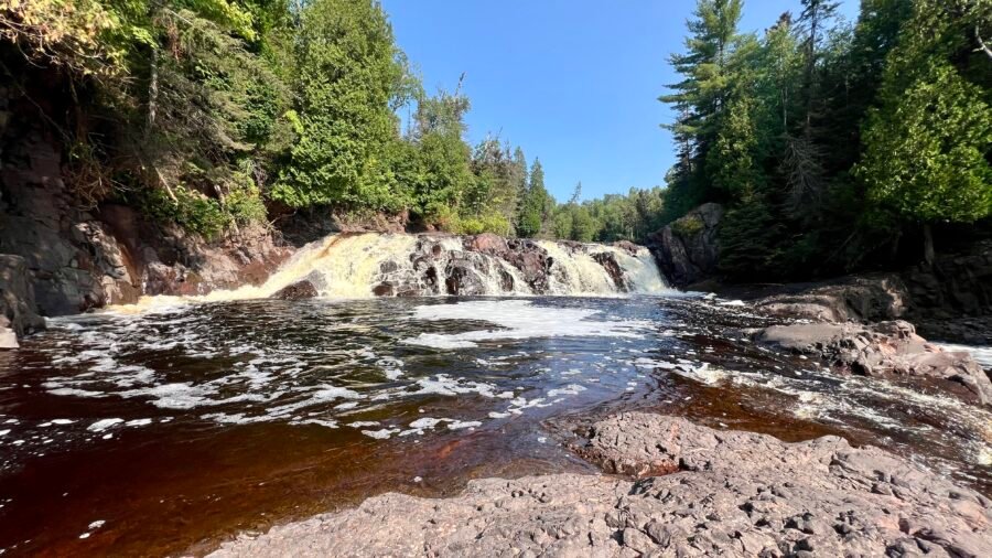
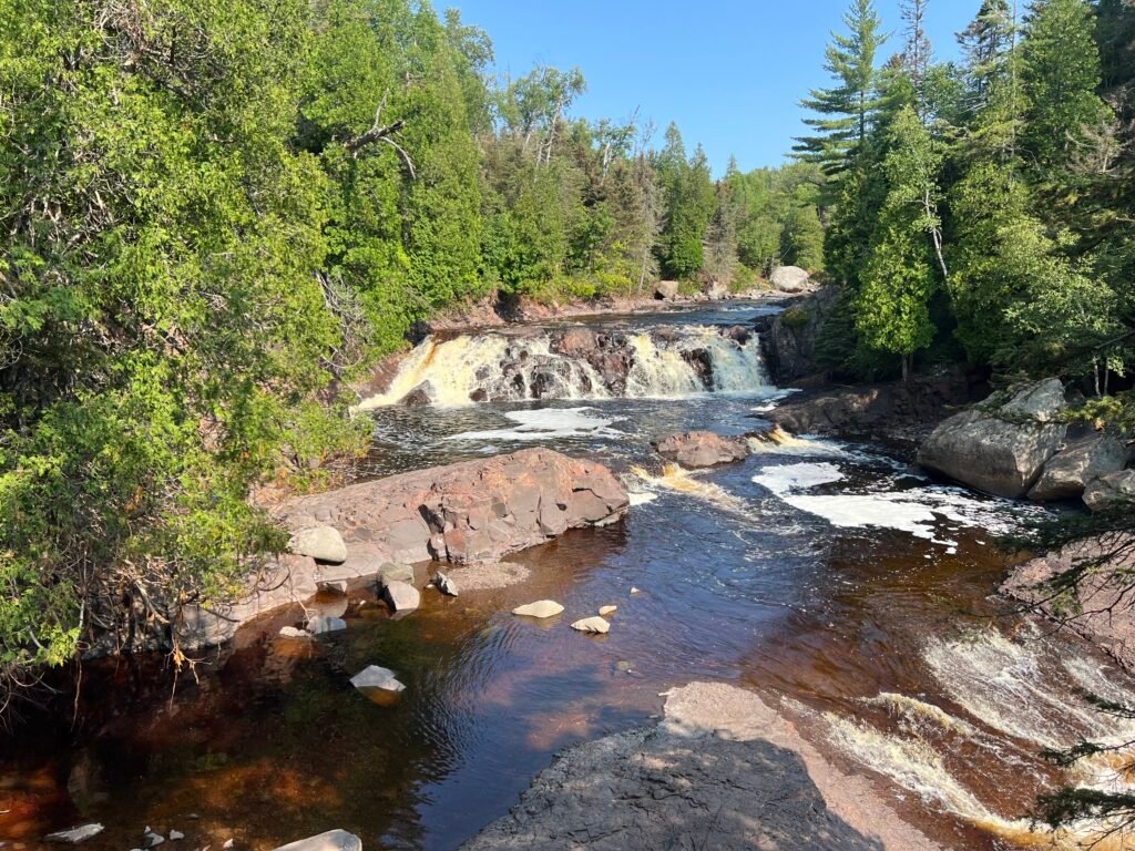
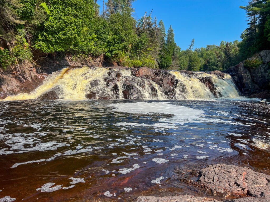
The payoff? Absolutely breathtaking. From this angle, Two Step Falls was easily my favorite viewpoint of the trip. The cascade felt more intimate, more powerful. Naturally, I waded through the shallow water to get closer.
Soon after, a couple of guys arrived with their dogs — who, I’m convinced, were eyeing the water longingly. If they could’ve ditched the leashes, they would’ve been splashing in seconds.
Photo: Descending to Two Step Falls—Morning Magic in Every Step!
Photo: Getting Up Close and Personal with Two Step Falls
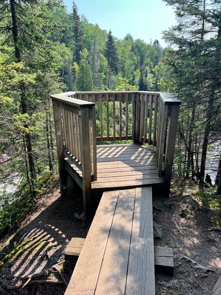
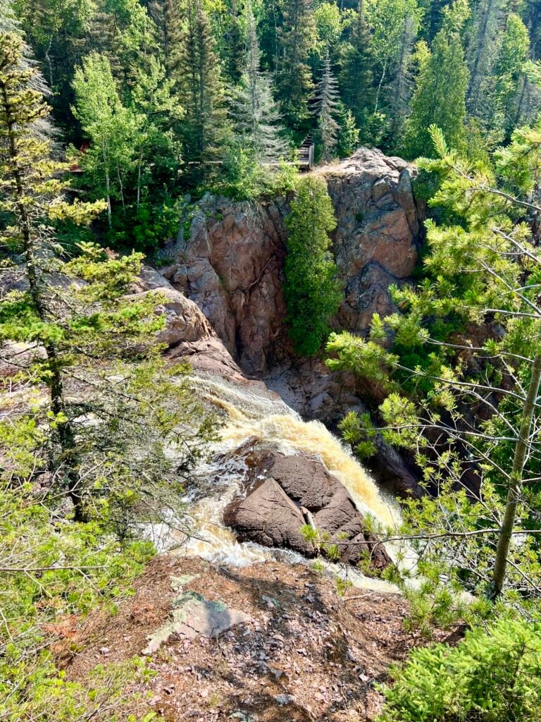
High Falls: The Pulpit and the Power
As I continued hiking, I reached a fork in the trail — left toward the parking lot or straight ahead to High Falls. Obviously, I went straight.
The overlook was spacious and dramatic, complete with what I can only describe as a pulpit-like platform. Naturally, I delivered an impromptu sermon to the forest creatures below.
Photos: High Falls Viewing Area | The Legendary Pulpit Spot!
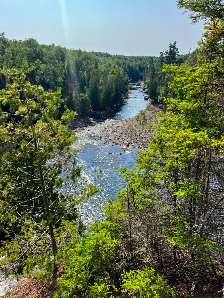
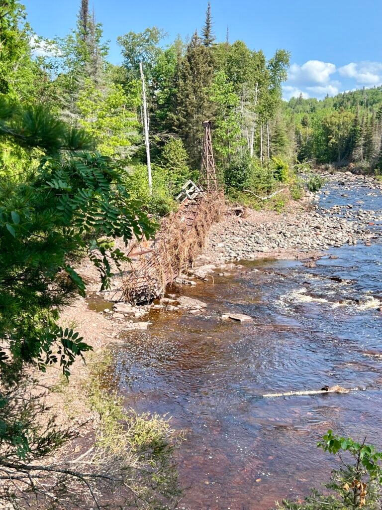
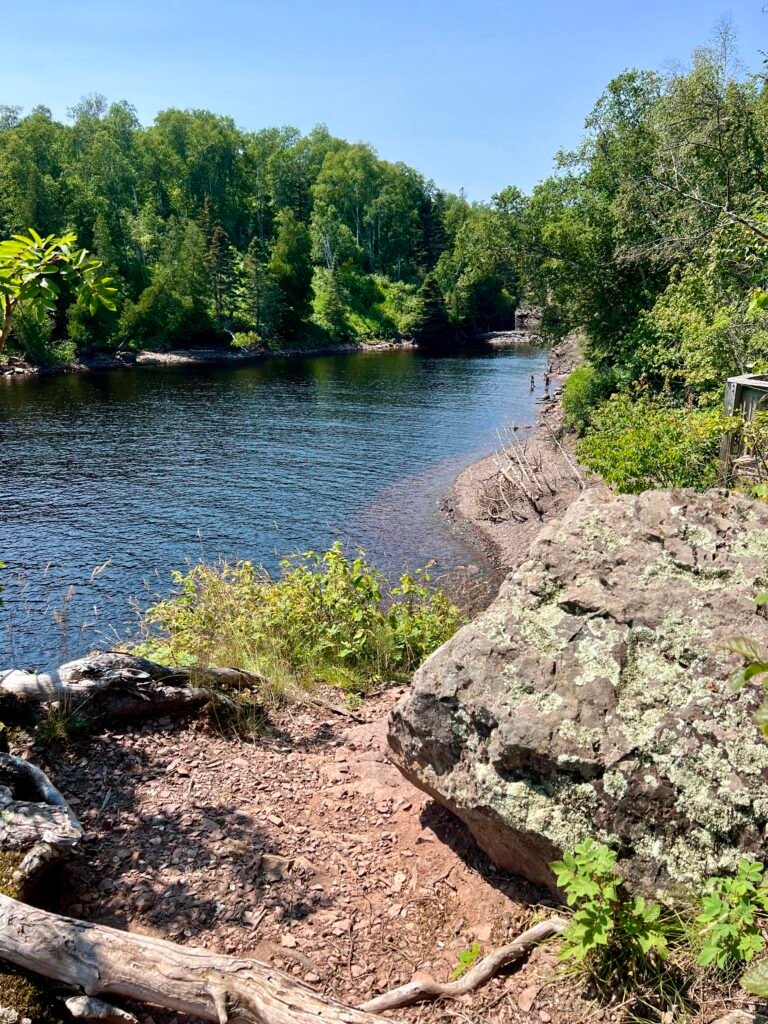
The views along the Baptism River were spectacular. Although the opposite side offers a more dramatic view of High Falls itself, this perspective gave a sweeping look at the surrounding gorge. Meanwhile, I also stumbled upon the twisted wreckage of the old swinging bridge — a powerful reminder of the storm that tore through the area.
Photos: Breathtaking Views of the Baptism River
Photos: High Falls from a Different Angle—Less Spectacular, but Still Stunning | The Twisted Swinging Bridge
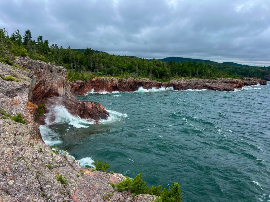
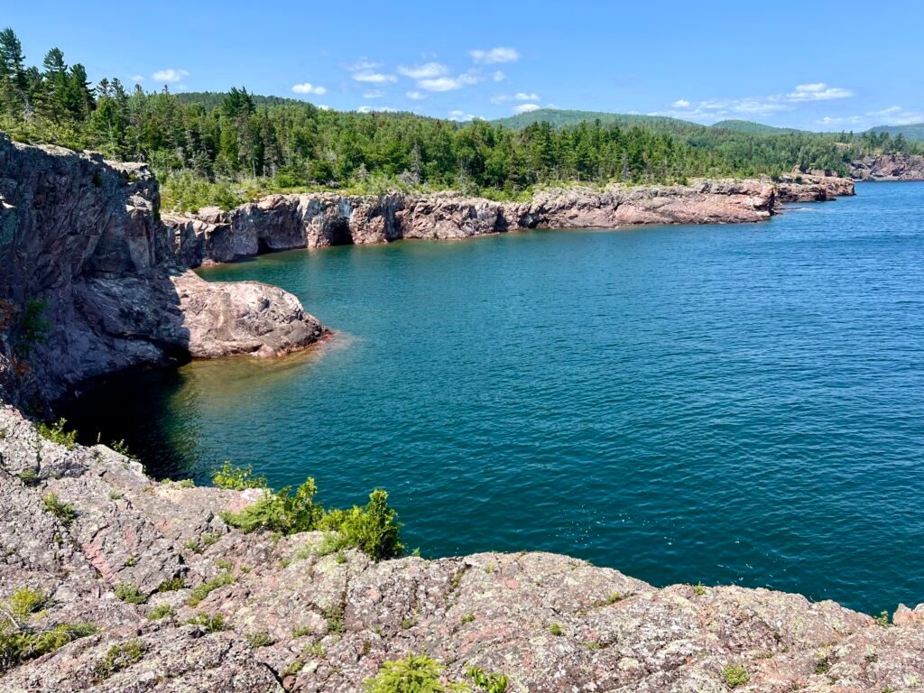
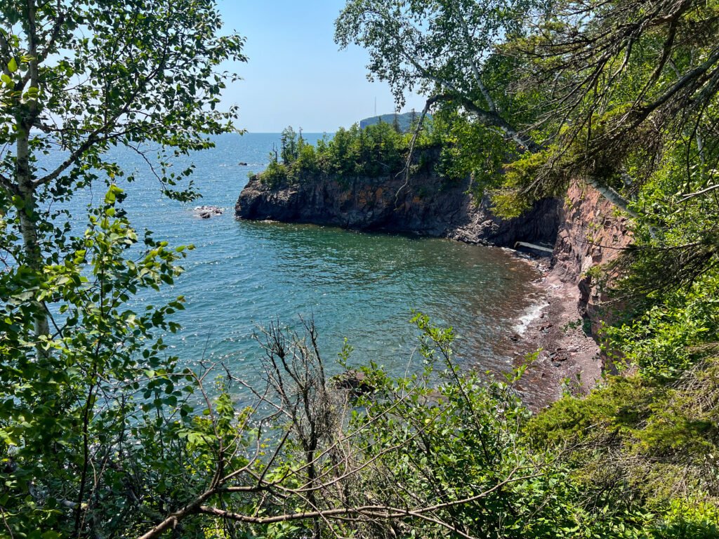
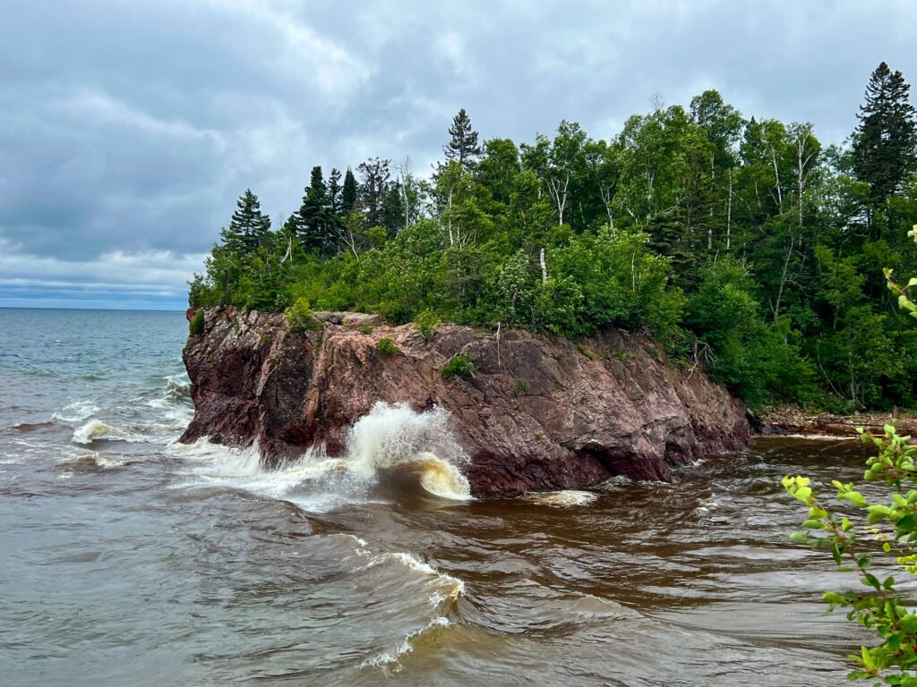
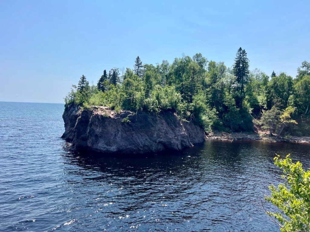
Take Two: Shovel Point and the River Mouth
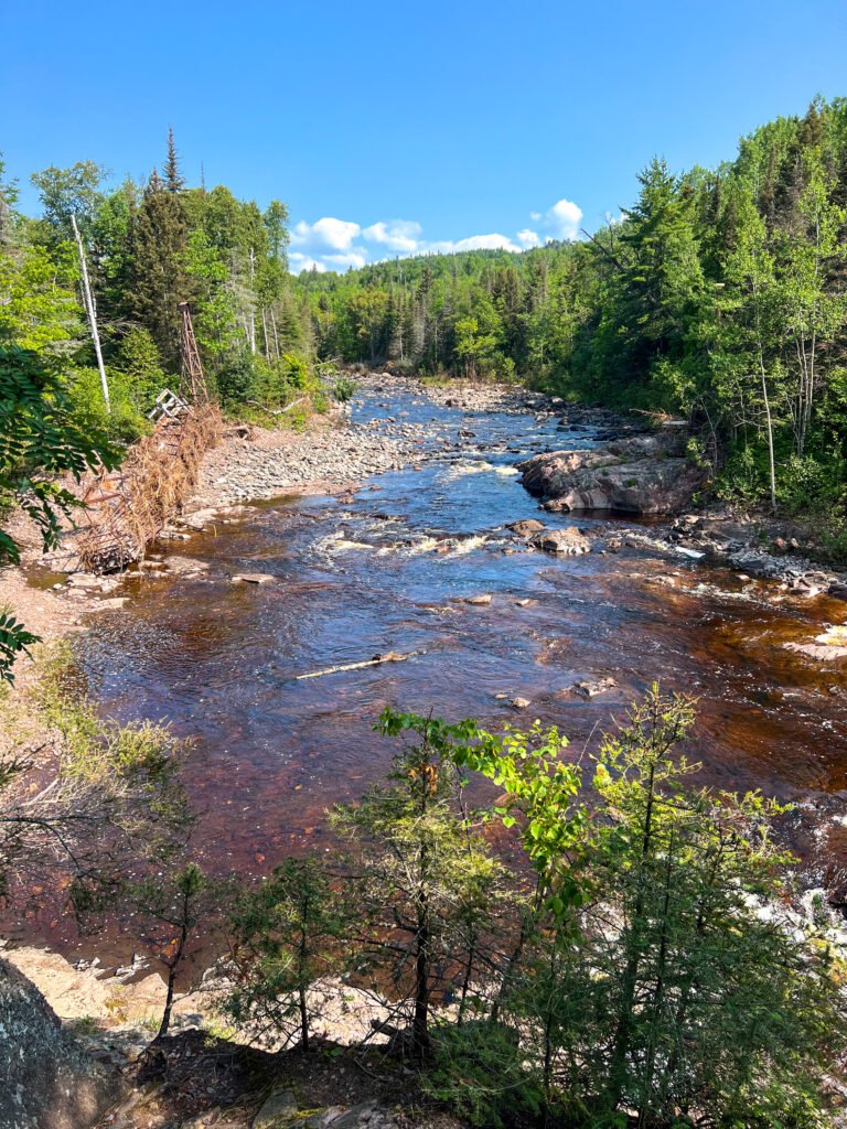
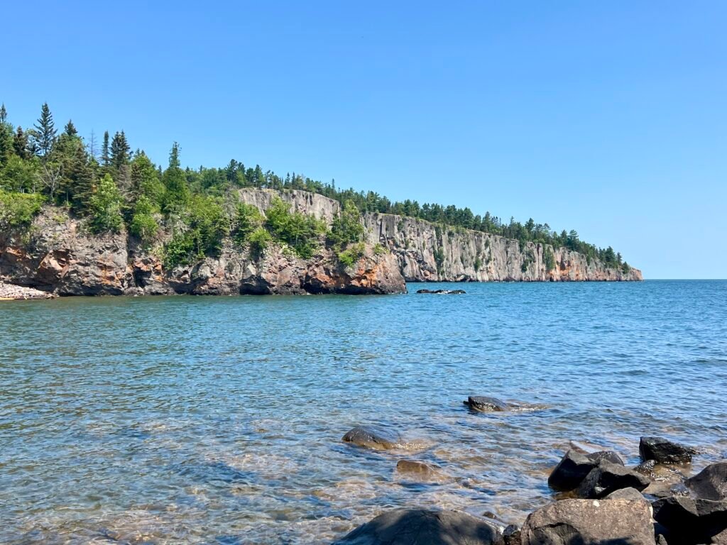
After packing up camp, I made my way back toward the visitor center and then out to Shovel Point and the Baptism River Mouth. What a difference a couple of days makes.
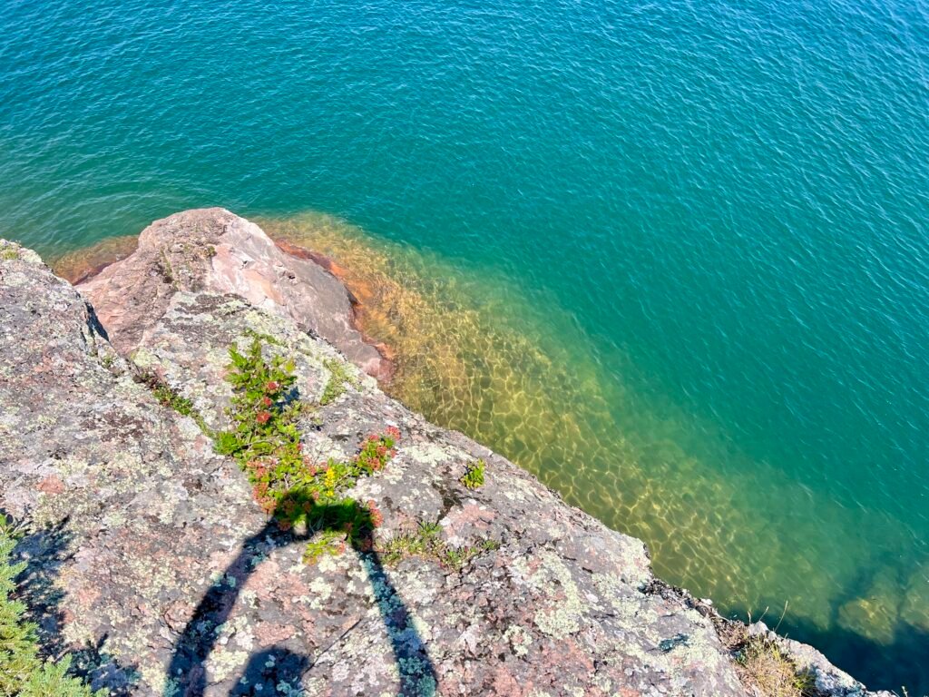
Previously, Lake Superior had been moody and gray. This time, however, it was calm, turquoise, and almost Caribbean-looking. The contrast was stunning.
At Shovel Point, I chatted with a friendly couple and simply soaked in the view. The cliffs, the clear water, the fresh breeze — this is why people fall in love with Minnesota’s North Shore.
Photos: A Calmer Lake Superior – View from the Beach | Palisade Head in the Distance
Photos: Lake Superior’s Dual Personalities—Two Days, Two Vibes!
Photos: Lake Superior – Turquoise Water and Incredible Views
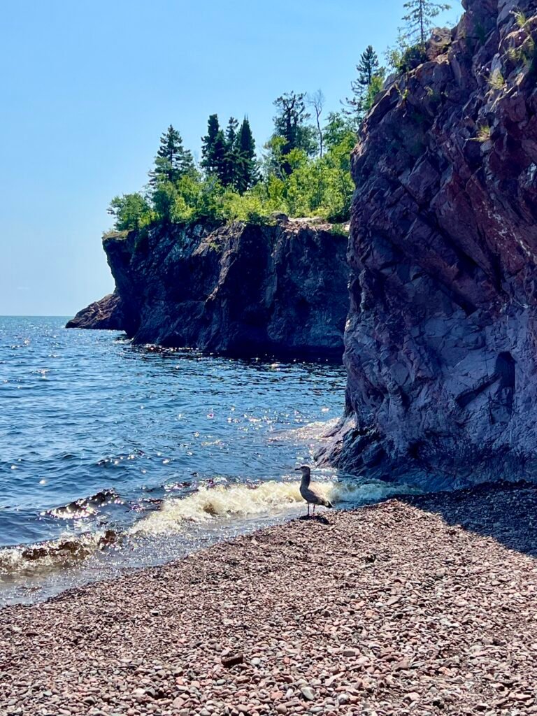
At the River Mouth, I climbed onto the rocks and, unexpectedly, found myself background scenery in someone’s FaceTime call. Seriously — do we need to broadcast every conversation to the world?
So instead, I slipped away to the rocky beach where I shared a quiet moment with a lone seagull. However, when a group of teens descended with towels and chatter, I knew it was time to make my exit.
Photos: The River Mouth—Totally Different Feels!
Photos: Chillin’ with a Seagull | The Baptism River—A Much Calmer Day
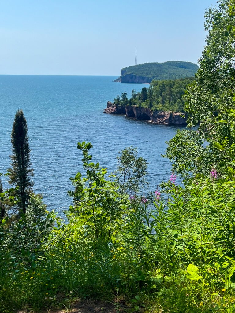
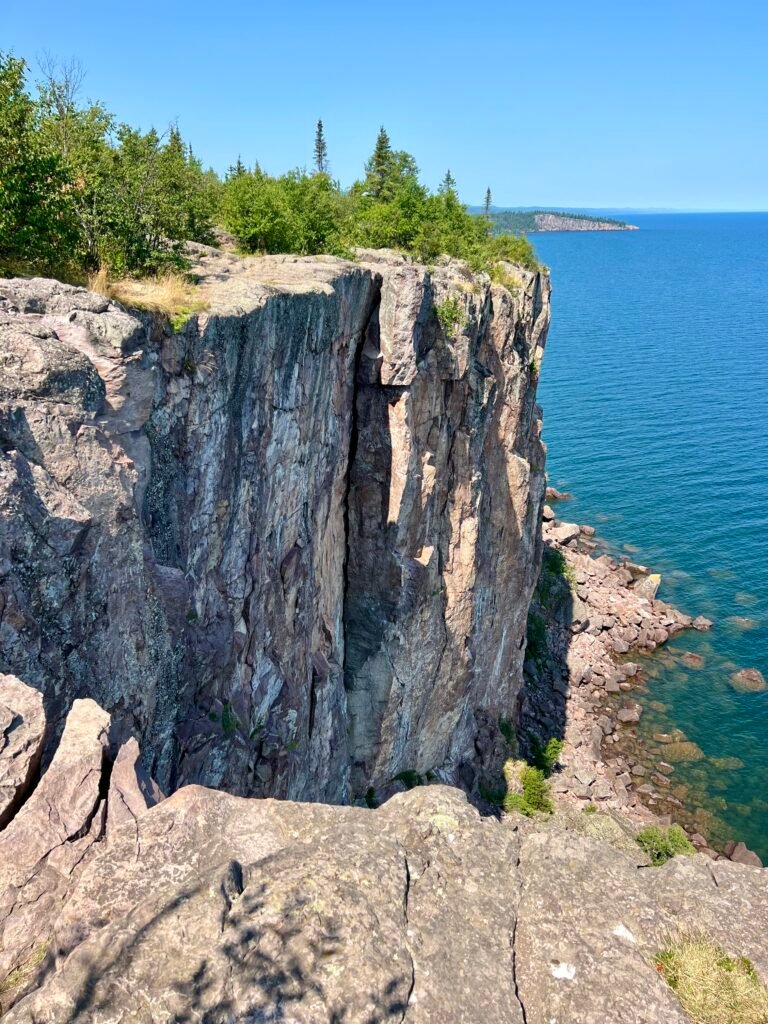
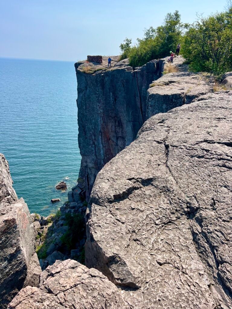
Palisade Head: Glad for Visit #2
As I drove south on MN-61, I decided to give Palisade Head another chance — this time from the top.
The overlook was buzzing with motorcyclists, cars, and rock climbers prepping their gear. Now that I could fully explore the cliffs, I finally understood the hype. The vertical drop-offs are dramatic, and for climbers especially, it’s a playground of granite and adrenaline.
In short, I was glad I made the detour.
Photos: Palisade Head – Views Towards Shovel Point | Climbers Preparing to Conquer Palisade Head
Wrapping Up: Tettegouche State Park, What a Gem
What started as a place I barely knew anything about quickly became one of the highlights of my Upper Midwest trek.
Tettegouche State Park exceeded every expectation. Between the rugged North Shore cliffs, the power of High Falls, the beauty of Two Step Falls, and the peaceful moments along the Baptism River, this park delivers diversity at every turn.
Moreover, this was my first deep dive into Minnesota’s North Shore — and it absolutely won’t be my last. If you haven’t explored Tettegouche State Park yet, put it on your list. The waterfalls alone are worth the drive.
Trust me — you need to see this one for yourself.
Two Harbors: Campground Chaos and Sweet Treats
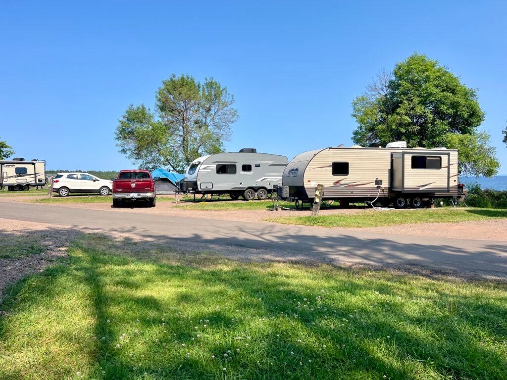
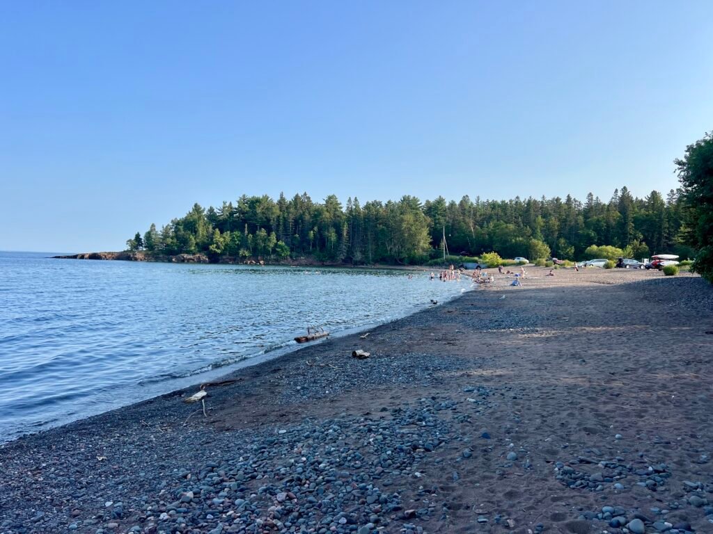
Next up was Two Harbors, just 30 minutes down MN-61. I stayed at Burlington Bay Campground, which, in contrast to Tettegouche, felt like sardine city. Campsites were tightly packed with little privacy.
Photos: Burlington Bay Campground—Sardine City! | Two Harbors Beach
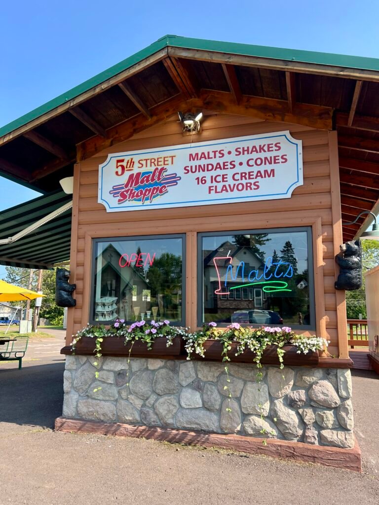
Naturally, I sought redemption in ice cream.
I made a beeline for the 5th Street Malt Shoppe and ordered Chocolate Peanut Butter alongside Coffee Ice Cream. Back at the campground, I ended the day with red wine on the beach, watching Lake Superior settle into evening.
Photos: 5th Street Malt Shoppe | My Delicious Reward!
Minneapolis Finds: Kowalski’s and More
In Minneapolis, I had to check out Kowalski’s Grocery, a renowned local chain. It did not disappoint! The fish counter was impressive, the prepared foods section was next-level, and the pizza was tasty — though a bit light on basil. Definitely worth a visit if you’re in town. I also stopped by Goodwill to donate some camping gear I couldn’t take home — like a folding lounge chair that had served me well.
Photos: Kowalkski’s in Minneapolis | Impressive Fish Counter!
Photos: Epic Prepared Goods Counter | My Pizza—Needs More Basil
Finally, I was off to the airport and then to Chicago for an REI Backcountry Navigation and Map Reading class. Pro tip: Use TSA-approved locks for your luggage. I learned this the hard way when TSA had to cut off my lock due to my hastily purchased one not meeting their standards. Oh well — lesson learned.
Photo: Parting Shot—Oops, Lesson Learned!
And with that little adventure, my month-long trek through the Upper Midwest comes to an end. What a summer to remember!
Tettegouche State Park, perched along the rugged North Shore of Lake Superior in Minnesota, is more than just a park — it’s a treasure trove of natural beauty, history, and adventure. Spanning nearly 9,400 acres, it boasts six inland lakes, four stunning waterfalls, and 22 miles of hiking trails. Plus, it’s one of just four state parks in Minnesota with rock climbing.
Whether you’re an adrenaline-pumping hiker or climber, an eagle-eyed birdwatcher, or just someone looking to soak in some serious tranquility, Tettegouche has got you covered.
And trust me, this place is anything but ordinary.
Nestled in the heart of Michigan’s Upper Peninsula, Tahquamenon Falls State Park is a treasure trove of natural wonders and breathtaking beauty. With nearly 50,000 acres of pristine wilderness, this park is home to one of the most impressive waterfall systems east of the Mississippi, drawing nature enthusiasts, photographers, and adventure seekers alike. Beyond the falls, Tahquamenon Falls State Park boasts over 35 miles of hiking trails that weave through dense forests, scenic overlooks, and along the picturesque Tahquamenon River. So, grab your bug spray, lace up those hiking boots, and let’s dive into my adventure through this U.P. gem!
Pronunciation Tip: Tahquamenon is pronounced tuh-KWAH-muh-non.
The Mighty Tahquamenon Falls
The crown jewels of Tahquamenon Falls State Park are undoubtedly the waterfalls themselves. The park features two main sets of falls: the Upper and Lower Falls. The Upper Falls, often referred to as the “Root Beer Falls” due to their distinctive amber color, are a sight to behold. Spanning 200 feet across and dropping nearly 50 feet, this waterfall is the second largest in volume east of the Mississippi River, only trailing Niagara Falls in size! The unique hue of the water is thanks to tannins leached from the cedar swamps that feed into the river—nature’s very own chemistry experiment. Visiting the UpperFalls offers multiple viewing platforms and trails that allow you to marvel at the roaring waters from various angles.
Photo: The Upper Falls
The Lower Falls offer a more intimate yet equally mesmerizing experience. This series of five smaller cascades encircle an island, accessible by rowboat or a charming footbridge. Exploring the island and the surrounding waters is like stepping into a tranquil escape—perfect for a leisurely day of picnicking, swimming, and photography.
Photo: Two of the Smaller Cascades that make up the Lower Falls
Roadtrips and Sunsets
I arrived in the afternoon, eager to explore. After checking into my campsite at the Rivermouth Campground, I couldn’t resist a quick detour north to Whitefish Point (check out my other post on Road Trippin’: The U.P.) – Great Lakes Shipwreck Museum and the historic Whitefish Point Lighthouse. On the way back to camp, I made a couple of stops that were just too good to pass up.
First, I swung by the Rivermouth Roadside Park, a small but scenic spot on the Lake Superior shoreline. Michigan seems to have a thing for these roadside parks, and honestly, I’m here for it. They’re like little oases for travelers, offering a place to picnic, rest, and soak in the scenery. A short hop down the road brought me to Clark Point Trail. Calling it a trail is a bit generous—it’s more like a quick walk from the parking lot to the lake—but it was fun exploring the shoreline. This spot is also a birdwatcher’s paradise, so bring your binoculars if that’s your thing.
Photos: Views from Rivermouth Roadside Park | And from the Clark Point Trail
Back at camp, I settled in for the evening with a campfire and dinner. But the real treat came later, as I headed to the campground’s beach on the Tahquamenon River. With golden hour approaching, I grabbed a cold one, found a log to perch on, and let nature’s show unfold before me. There’s something magical about watching the sun dip below the horizon while the river flows quietly by—it’s the perfect way to end a full day of adventure.
Photos: My Campsite | The Evening’s Fire
Photos: The Tahquamenon River – great for Kayaking | Enjoying a Cold One!
Photos: Enjoying Nature’s Show | Golden Hour at the Tahquamenon River
Photo: The Perfect Way to End the Day!
No time to wait on late rangers
First, A note to fellow adventurers: Tahquamenon Falls has two main entrances, one at the Upper Falls and the other at the Lower Falls. It’s not uncommon to see long lines, especially in the morning or around 3 PM when campers are checking in.
Photo: Lower Falls Entrance from the Parking Lot | Hard to Get Lost Here!
Photos: Lower Falls Map | Upper Falls Map
Photo: Tahquamenon Falls State Park Map
The next morning, I was up early and ready to hit the trails. My first stop was the Lower Falls. After waiting a bit for the entrance booth to open on time at 8:00 AM (spoiler alert: it didn’t), I decided to get a head start on my day. I wasn’t going to let the rangers late start ruin my plans! Just up from the parking lot, there’s a handy area with bathrooms, the Lower Tahquamenon Falls Café & Gift Shop, and even rowboat rentals for exploring the Tahquamenon River. The hike from the gift shop to the Lower Falls is only a half-mile, mostly on a raised boardwalk. Being early, I had the place almost to myself, save for a few other early risers. Along the way, you’ll spot a wooden plaque featuring the Prayer of the Woods—a reminder to be mindful and respectful of the natural beauty around us.
Photos: Bear Cubs at Play – a sculpture at the entrance | Rowboats for Rent
Photos: The Boardwalk to the Lower Falls | The Prayer of the Woods
The Lower Falls consist of a series of five smaller falls cascading around an island. You can either view them from the riverbank or cross the Ronald A. Olson Island Bridge to explore the island. I’d recommend the latter—it’s a short half-mile loop around the island, and you get to see all five falls up close. Plus, the bridge itself is pretty cool, especially with the river roaring below after the recent rains.
Photos: Ronald A. Olson Island Bridge
Photos: The Island Loop – It’s pretty flat until you hit the boat dock area, where you’ll find a few stairs
Photos: Morning Views from the Island Loop
Photos: A few views of the Cascades at the Lower Falls from the Island
Feeling inspired and ready for a bigger adventure, I changed into my trail runners, grabbed my poles, and lathered myself in bug spray. My next challenge: the 4-mile one-way hike from the Lower Falls to the Upper Falls along the River Trail, known for its scenic beauty, winding through old-growth forests and along the river.
The River Trail: A Hiker’s Delight with Otters
Now, let me give you a heads-up: this trek is not for everyone. It’s got its fair share of exposed roots, hilly terrain, numerous staircases, and was a bit overgrown in some areas. But if you’re up for the challenge, the rewards are more than worth it. At one point, I even stumbled upon a group of river otters frolicking along the riverbank. They didn’t notice me at first, but when I “clicked” to get their attention for a photo, they weren’t too thrilled and quickly disappeared into the water. I guess not everyone is a fan of the paparazzi!
One thing to note is that the trail isn’t always the best marked or maybe I just wasn’t paying attention. I may or may not have taken a wrong turn at one point, but hey, getting lost is part of the adventure, right?
Photos: River Trailhead at the Ronald A. Olson Island Bridge | Time to walk the plank and dodge some roots on the River Trail!
Photos: The River Trail – A fun combo of dirt paths and wooden boardwalks!
Photos: The Otters – Before they knew I was around | And after – when they gave me an earful!
Photos: Check out one of the amazing views of the Tahquamenon River along the trail! | And yep, even on the way up to the Upper Falls, you’ll hit some stairs going down—perfect cardio workout!
Stairmasters and Nature’s Powerhouse
After what felt like a mini-marathon, I reached the Upper Falls. The 181 stairs down to the Gorge View seemed like child’s play after my hike, and the view was nothing short of spectacular. From here I got my first glimpse of this massive cascade with a nearly 50-foot drop and a width of over 200 feet. The sheer volume of water crashing down is mesmerizing—it’s said that during peak flow, over 50,000 gallons of water rush over the falls every second, hence getting the title of the second largest east of the Mississippi.
Photos: Coming off the River Trail and hitting the Upper Falls Viewing Areas | First stop: the Gorge View!
Photos: Stairmaster Workout – 181 stairs down to the Gorge, then back up
Photos: Boardwalk to the Viewing Area | Along the Gorge
Photos: The Upper Falls from the Gorge Viewing Area
If you’re a sucker for scenic spots, the Brink View area is another must-visit. After another 94 steps down, you’ll be rewarded with a front-row seat to one of nature’s most powerful shows. This area was definitely more popular, and I had to navigate around a few selfie-taking tourists, but the view was worth it. After taking in the sights, I headed to the Upper Falls parking lot, a short 0.3-mile walk on a paved walkway. This spot has some nice perks too, like the Tahquamenon Falls Brewery & Pub, Camp 33 Gift Shop, an outdoor picnic area, and even a food truck, though it wasn’t open when I visited.
Photo: The “Root Beer Falls” from the Brink Viewing Area
After all that hiking, I figured I deserved a reward, so I made my way to the Brewery & Pub. Unfortunately, nothing on the menu really caught my eye, but I couldn’t pass up the chance to try one of their beers. I went with the Falls Tannin, an American Red Beer. It had that deep amber hue, just like the Upper Falls, but the taste was… well, just okay. Not exactly something to write home about, but it hit the spot after a long day on the trails.
Photos: Tahquamenon Falls Brewery | Tried the Falls Tannin – does it look like the falls? | Today’s brews!
Trail Running and Campfire Bliss
Rested and refreshed, it was time to head back down the River Trail to the Lower Falls parking lot—a solid 4+ miles back. This time, I took the Nature Trail to the River Trail, the path I had hiked up earlier. Feeling a bit adventurous, I decided to turn the hike into a trail run. The path was getting busier with other hikers, so I had to weave around a few people, but it was a fun way to end the day.
Back at the Lower Falls parking lot, I packed up and headed to my campsite for the night—The Lower Falls Portage Campground. Back at the campsite, I treated myself to a hot shower, made another campfire, and settled in for the night. I had a 7-hour drive to Duluth, Minnesota, ahead of me the next day, so I knew it would be an early night. But as I sat by the fire with a cold drink in hand, I couldn’t help but feel a sense of contentment. Tahquamenon Falls State Park had lived up to every expectation and then some.
A Memorable Adventure
Tahquamenon Falls State Park is more than just a place to visit—it’s a place to experience. Whether you’re marveling at the mighty falls, exploring the serene hiking trails, or simply soaking in the natural beauty, this park offers something for everyone. And if you’re lucky, you might even have a few memorable encounters with the local wildlife. Just don’t forget to pack your bug spray, plan to camp in the park, and get ready for an adventure you won’t soon forget. So, what are you waiting for?
The Pasty Pursuit: A Culinary Quest
As I drove through the U.P., I kept seeing signs for pasties (pronounced pass-tee, not pay-stee.) —what are these mysterious pastry things? As a curious foodie, chef, and restauranteur (also a pescatarian), I had to find out. After some quick research, I found a place in Ishpeming that had a vegetarian option. I headed to Lawry’s Pasty Shop, only to be disappointed—apparently, they don’t cook the vegetarian ones on-site. Determined not to leave empty-handed, I backtracked to Irontown Pasties in the heart of Negaunee. After a bit of a wait (perfect for catching up on Words with Friends), I finally snagged a veggie-cheese pasty. The staff was super friendly, and when I asked about the “proper” way to eat it, they handed me a no-name ketchup bottle and said, “With ketchup!”
My first impression? Well, let’s just say it looked like an Irishman on the beach in Miami—stark white. The dough was a bit undercooked, especially where it was folded. The filling was a mix of broccoli, cauliflower, carrots, onion, potato, cream cheese, cheddar cheese, mozzarella cheese, and spices. It wasn’t horrible, but it wasn’t great either. It was like winning a match by default—you get the victory, but it feels a bit anticlimactic. With that, I headed for Duluth, Minnesota.
Photos: Irontown Pasties | My Veggie-Cheese Pasty – with a side of ketchup, of course!
Meeting a Michigander usually comes with an impromptu geography lesson. They hold their left hand with the palm facing them to represent Michigan’s Upper Peninsula (U.P.), where the Yoopers reside. Their right hand held upright with the palm facing outward, maps out the Lower Peninsula—the area below the Mackinac Bridge, often called “The Mitten” and home to the Trolls. This hand map is a classic and quirky way for Michiganders to show off their state’s geography, which can be charmingly unique or, depending on your perspective, a bit annoying. Now let’s explore the U.P.
Photos: A Michigander Map | A Traditional Map
The Great Lakes’ Greatest Hits
If the Great Lakes had a Greatest Hits album, it would definitely be titled Lighthouses & Waterfalls – these iconic features are everywhere you turn. After leaving L’Anse, I cruised east on US-41 for a scenic hour and fifteen minutes, landing in Marquette, Michigan—the largest city in the U.P. With a population of just under 20,000, Marquette blends small-town charm with big-city amenities. I love to make pit stops during my road trips, so naturally, Marquette called for a quick exploration.
This lakeside town boasts stunning Lake Superior views, and it’s home to Northern Michigan University, which adds a youthful vibe to the area. If you’ve got the time, a hike up Sugarloaf Mountain offers unbeatable vistas, with a panoramic view that stretches for miles—perfect for taking in the sheer scale of Lake Superior, which, by the way, holds enough water to cover North and South America in a foot of water. Or you can take a leisurely stroll along the harbor for some serious photo ops.
One stop you shouldn’t miss is the decommissioned Ore Dock, a towering relic of Marquette’s industrial past. Once a bustling hub for shipping iron ore, this massive structure now stands as a dramatic piece of history along the waterfront. Its rusted, steel frame and vast length make for an impressive sight, and the dock offers a unique perspective on the city’s maritime heritage. I also wandered over to the Marquette Harbor Light Station, only to discover you need to sign up for tours to actually explore the grounds—something to keep in mind if you plan a visit! It was a brief stop, but I’m glad I checked it out.
Check ☑️, saw Marquette.
Photos: The Lake Superior Shoreline | Marquette Harbor Light Station
Photo: The Decommissioned Ore Dock
Next up on my journey, Wagner Falls Scenic Site in Munising, Michigan—a spot that the Wisconsin ladies I met at Starved Rock State Park raved about. If you caught my earlier posts, you’ll remember these ladies also tipped me off about Parfrey’s Glen, which I checked out earlier this month. A quick 50-minute drive and I found myself at the falls.
Photos: The Trailhead | A Glimpse into the Park’s History
Wagner Falls is located just 1.5 miles south of Munising, right off Michigan 94. Parking is available on both sides of the road, and I managed to snag one of the last spots. This little gem is a Michigan State Scenic Site, and the 0.25-mile trail is an easy stroll that takes you through a dense forest of old-growth pine and hemlock trees. The falls themselves are a 20-foot cascade that tumbles over limestone and sandstone—geological formations that are hundreds of millions of years old. Perfect for those Insta-worthy pics. Be prepared, though—the place draws a crowd, including city folk who seem more glued to their phones than the stunning falls in front of them. But don’t let that stop you—Wagner Falls is definitely worth a stop if you’re passing through, though maybe not worth going out of your way for.
Photos: Wagner Creek | Wagner Falls and Scenic Observation Decks
Photo: Wagner Falls
Who Knew?!
I hit the road again, heading west toward Tahquamenon Falls State Park, a scenic hour and a half drive away. The park covers nearly 50,000 acres, making it Michigan’s second-largest state park. My spot for the night was Rivermouth Campground—about 17 miles from the Lower Falls and just 5 miles south of Paradise, Michigan, off Michigan 123. Weekends in the U.P. can get pretty busy, so I had to split my visit between two different campgrounds. But hey, I’m mobile, so no big deal!
Photos: Rivermouth Campground Entrance on Michigan 123 | My Campsite for the Night
With limited hiking options at Rivermouth, I decided to venture out to Whitefish Point. Even though I arrived just after the museum and lighthouse had closed, I was thrilled to still have the chance to explore the grounds and beach. Whitefish Point is home to the Great Lakes Shipwreck Museum and the historic Whitefish Point Lighthouse—both perfect for a dose of maritime history. The museum’s exhibits on the infamous Edmund Fitzgerald are as fascinating as they are chilling, featuring haunting artifacts from the shipwreck, including the ship’s bell, which was recovered in 1995. Climbing the lighthouse offers breathtaking views of Lake Superior, and the beach is a treasure trove of driftwood and shipwreck debris. Did you know this area is considered the Graveyard of the Great Lakes? With over 240 shipwrecks in the Whitefish Point area alone since 1816, it’s a must-see for anyone fascinated by Great Lakes lore or simply looking for a memorable stop! Who knew I’d stumble upon such a cool place?
Photos: The Whitefish Point Light Station | An Iron Winch on the Museum grounds
Photos: Rudder from the M.M. Drake | History of the Graveyard of Lake Superior
Photos: Driftwood on the Beach | The Sandy Beach at Whitefish Point
Radio Flashback to 1976!
The Edmund Fitzgerald, a massive freighter that met its tragic end in a fierce 1975 storm, remains one of the most haunting maritime mysteries. Gordon Lightfoot’s classic “The Wreck of the Edmund Fitzgerald” immortalizes the ship’s story with evocative lyrics and a soulful melody, paying tribute to the 29 crew members who lost their lives that night. Standing on that beach, gazing out at the vast expanse of Lake Superior, it felt like being at the ocean—and realizing this was the area where the Edmund Fitzgerald sank was truly awe-inspiring.
Photos: Gordon Lightfoot’s Album | The Edmund FitzgeraldPhoto: Edmund Fitzgerald Memorial
Why Not?
In the end, being spontaneous is what makes any road trip truly memorable. It’s those detours, the unplanned stops, and the little side adventures that often turn out to be the highlights of the journey. You never know what hidden gems you’ll stumble upon, like a lighthouse you didn’t plan to visit or a waterfall tucked away just off the road. And let’s be honest—you might not find yourself back in these parts anytime soon, so why not seize the moment and explore? It’s all part of the adventure, and sometimes, the best stories come from the places you didn’t even know you’d find. So next time, just go for it—you might just discover something amazing.
After wrapping up my adventure at Pipestone National Monument (check out my last post, Road Trippin’ From Iowa to North Dakota), I headed north on Interstate 29 to my 47th state—North Dakota. With Montana, Wyoming, and Alaska still on my bucket list, I was ready to explore Fort Ransom State Park and see what North Dakota had in store. Before diving into the park, I made a quick stop at the actual Fort Ransom site, located just 3 miles south of the park entrance, to kick off my North Dakota adventure with a bit of history.
Photos: The Historic Fort Ransom Site | Entrance to Fort Ransom State Park
Dances with Wolves
As I rolled into Fort Ransom State Park, it felt like I had driven straight into a scene from Dances with Wolves. I half expected Lieutenant John Dunbar (Kevin Costner) to come galloping up and ask what I was doing there. The rugged terrain, lush greenery, and sweeping views felt straight out of a classic Western—a perfect setting for some epic outdoor adventures.
Upon arrival, I made a beeline for the visitor center. Even though I had a camping reservation, North Dakota has this quirky little rule where you still have to pay an entrance fee. They don’t roll it into the camping fee, which I found a bit odd. The woman at the visitor center was friendly but sad to say didn’t have much to add about the park’s highlights. However, she did tip me off about the $7 firewood bundles sold by the camp host—a tale for later in this post. With map in hand, I headed to my campsite, lucky number 23, and got settled in.
Photos: Visitor Center | My Campsite – Lucky #23
Photos: Trail Map | Campground Maps and Park Information
Hills, and yes, Yurts!
As I set up my campsite, I couldn’t help but notice the area’s unique blend of rolling hills, dense trees, and sprawling farmland. The mosquitoes were out, but they were nowhere near as bad as the swarms I encountered in Wisconsin and Iowa. With a bit of daylight left, I decided to explore a bit.
I set off on a roughly 2-mile loop, starting from the back of the campground. My journey began on the South Gate Trail, where I crossed the North Country Trail before following a service road down to the Pederson Hills Trailhead. This trail starts with an incline through oak woodlands, up to a ridgeline, and across mixed-grass prairie, offering stunning views of the countryside. From there, I followed the Spur Trail—a winding connector between the Pederson Hills and Ridgeline Nature Trails.
Photos: Pederson Hills Trail
Photo: Panoramic View from the ridge on Penderson Hills Trail
Photos: Some of the many trailmarkers including where the Spur Trail meets the Ridgeline Nature Trail
A short trek down the Ridgeline Nature Trail led me to Yurt Loop, where the park’s quirky yurts immediately caught my eye. These unique accommodations, along with a refurbished stagecoach, add a charming Old West touch to your stay. As evening settled in, I marveled at how long the daylight lingered and how cool the temperature had dropped. Despite the crisp night air, my car stayed surprisingly warm—if only there had been a breeze to stir things up a bit.
Photos: One of the Yurts | The Percheron Wagon for a one-of-a-kind stay!
No Wood for You!
Camping at Fort Ransom State Park was the perfect way to soak in the park’s tranquil beauty. My campsite, nestled in a shaded corner of the campground, offered just the right balance of seclusion and proximity to the bathrooms and shower house. The only hiccup? A determined bird dive-bombed my head as I walked across the field, despite there being no trees nearby—definitely an unexpected challenge! On the bright side, I stumbled upon a cute painted rock on a bench near the building. As night fell, I enjoyed stargazing under a clear sky, free from city lights and treated to a breathtaking display of stars.
If you’re planning a visit to Fort Ransom, I highly recommend camping. Whether you’re staying in a tent, a yurt, or even the quirky refurbished stagecoach, it’s the perfect way to experience the park’s unique charm. Just a heads-up: if you’re hoping to grab a $7 bundle of firewood from the camp host, be prepared for a bit of luck. Unfortunately, the day I arrived was his day off, so I had to make a quick trip into town to stock up.
Photos: Bathrooms and Shower House | The Painted Rock I Found
Is “Sleeping In” a Camping Tradition?
The next morning, I was up and at it early. After a quick shower and some organizational maneuvers for my upcoming trip to Chicago, I hit the trails. It’s worth noting that I was pretty shocked at how late campers sleep in. By 9:15 AM, I had done so much and I was ready to go, but most of the camp was still snoozing away. Don’t get me wrong—I’m all for a good night’s sleep, but the day is slipping by folks!
One thing that really impressed me was how well-labeled the trails are at Fort Ransom. My hike started with a visit to the picnic pavilions, where I discovered a volleyball court—a fun spot for groups looking to mix a bit of sports with their nature retreat. After a quick pit stop at the outhouse, I set off on the Ridge Line Trail. The breeze had picked up, which was a blessing for keeping both the bugs and the heat at bay. The trail itself was peaceful, with the melodic chirping of birds providing the perfect soundtrack to my hike.
Photos: One of the Picnic Pavilions | A Pit Toilet, aka Outhouse
Watch out for Road Apples!
From Yurt Loop, I climbed back up the Ridgeline Nature Trail, which offered a good cardio workout with its elevation changes. As I hiked, I encountered some intriguing trail markers, including cryptic letters that I still need to decode. At the top, the trail forked, and I chose to go left, continuing on the Ridgeline Nature Trail. This section was marked by horse tracks and the occasional road apple (aka horse manure), indicating the trail’s popularity with equestrians.
Photos: On the way to Yurt Loop | Ridgeline Nature Trailhead
Fort Ransom State Park boasts over 20 miles of non-motorized trails, including loops, connectors, and segments suitable for hiking, horseback riding, biking, cross-country skiing, and snowshoeing. As one of North Dakota’s designated horse parks, it’s equipped with 68 corrals, catering to both riders and horses.
The Ridgeline Nature Trail offered a mix of serene flat stretches and some elevation changes, with occasional deer tracks adding to the sense of wilderness. I briefly explored the Nelson 80 Trail, but found it rather flat and unremarkable, so I quickly returned to the Ridgeline. I then connected with the Firebreak Trail, which led me to a junction with several other trails, including the Little Twig Trail. The entire stretch from the start of Ridgeline Nature Trail to the Little Twig Trail junction was only about 8/10ths of a mile. A good warm-up for the day.
Photos: Deer Trakcs | The endless Nelson 80 Trail
Photo: View from the Ridgeline Nature Trail
More Evidence of the Recent Heavy Rains
The Little Twig Trail, a short 6/10-mile path, provided a relaxing stroll with the soothing sound of a bubbling brook enhancing the peaceful vibe. However, the recent heavy rains had caused some sections of the trail to flood, and the brook was overflowing. A bridge up ahead looked like it had definitely seen better days—possibly the one the visitor center staff had mentioned.
Despite the wet conditions, I pressed on and found myself at the Little Twig trailhead, located on the backside of the Yurt Loop. This marked a full loop back to where I had started earlier in the day, but I wasn’t done yet.
Photos: Brook along the Little Twig Trail | The Brook Overrunneth
Photos: More of the wet Little Twig Trail
Insta-worthy Views
After leaving the Little Twig trailhead, I made my way toward the North Fork Trail. With the parallel road blocked off to car traffic, I opted to hike up the road to the ridge instead. The choice was a breeze—literally—since the road was less buggy and offered a refreshing wind.
Photos: Road and Trail Intersection—Redetzke Ridge Trail (where I’ll loop back) branches off to the right | The Road Leading Up to Valley and Prairie Vista
Photos: At the Vista—A Glimpse of the Area’s History and About the Prairie
At the top, I reached the Valley and Prairie Vista, where the panoramic views and cooling breeze made the climb totally worth it. This spot is a must-visit in the park, offering a serene overlook perfect for soaking in the scenery, grabbing a snack, and snapping a few pics for the ‘Gram.
Photo: The Incredible View from the Vista
From there, I continued on the Valley View Trail, a 0.8-mile multi-use path that begins at the Scenic Overlook parking lot and winds its way down to the Sunne Farm. The trail offers stunning views of the Sheyenne River Valley as it curves along native prairie slopes, dotted with grasses and colorful wildflowers. After crossing the intersection with Redetzke Ridge Trail, I kept heading toward the Sunne Farm.
Photos: The Valley View Trail—A Long, Flat Stretch, Perfect for Horseback Riding
Photo: Heading down into the Valley towards Sunne Farm
A Step Back in Time: Visiting the Sunne Farm
The Valley View Trail led me to a farm that felt like a step back in time. One of the highlights was meeting Troy the blacksmith, whose family has been practicing the trade since 1880. The farm offered a unique glimpse into the park’s agricultural roots, providing a peaceful setting to reflect on the area’s rich history. The staff was bustling, preparing for Sodbuster Days—a local annual festival that celebrates the region’s agricultural heritage. They were surprised to hear I wasn’t sticking around for the event, which is known for its tractor parades, old-fashioned games, farm-fresh produce, homemade treats, and local crafts. If you’re in the area during this time, it’s definitely worth checking out.
Photos: Highlights from Sunne Farm
Photo: Troy’s Blacksmith Shop
Photos: More Highlights | Getting ready for Sodbusters Day
With the farm visit behind me, I made my way back toward the Redetzke Ridge Trail. Although the road offered an easier route, I chose the trail for its scenic appeal—and it didn’t disappoint. The Redetzke Ridge Trail didn’t disappoint, offering beautiful views and a more immersive experience in the park’s natural beauty. By noon, I found myself back at the intersection of the road and Redetzke Ridge, feeling accomplished and ready for a well-deserved break. I headed back to camp, where I showered, wrote a few postcards, and enjoyed some quiet time.
Photo: Heading Back Up the Valley View Trail | Where Valley View and Redetzke Ridge Trails Meet
Photos: A Few of the Wildflowers You’ll Encounter on Your Hikes
Fort Ransom: Not Quite Yosemite, But Worth a Visit!
Fort Ransom State Park may not be a bucket-list destination like Yosemite, but it’s definitely worth a visit if you find yourself in North Dakota. The park’s blend of history, scenic trails, and peaceful vibes offers a refreshing escape into nature. Whether you’re hiking, horseback riding, or just soaking in the views, Fort Ransom provides plenty of reasons to slow down and enjoy the simpler things. So if you’re passing through, don’t miss out on this little slice of prairie paradise—you might just discover a new favorite spot!
Photo: A Slice of Prairie Paradise
Oh, Geez…
Next up, I made a stop at the Fargo Visitor Center to check out the infamous wood chipper from the movie Fargo—because, when in North Dakota, how could you not? But that wasn’t the only surprise. I spotted a Facebook post from my old friend, Tim from Orlando, who just so happened to be hosting a garage sale nearby. I couldn’t resist swinging by to surprise him. It was a fun little reunion, and if I wasn’t on a tight schedule, I would’ve stuck around longer. Nonetheless, it was the perfect way to wrap up my North Dakota adventure before heading to Minneapolis to stash my camping gear. Chicago’s next on the agenda, and then back to Minneapolis for round two! Catch You on the Road!
Photos: The Famous Wood Chipper from Fargo | Not Looking Too Scary Using to It, LOL
Photos: Mini Reunion with Tim | My Minneapolis Storage Unit
Calling Devil’s Lake State Park “popular” is like calling the Grand Canyon “a big hole”—a serious understatement! This place is the ultimate playground, with a sandy beach, picnic areas, and trails even the most leisurely strollers can handle. It reminded me of Lincoln Woods State Park in Rhode Island, especially when I was high up on the West Bluff trail, still catching the sounds of beachside fun. Locals flock here like it’s the first sunny day in ages, and with a $16 car fee for non-residents ($13 for residents), that popularity comes at a price. So, if you’re planning a visit, be ready for crowds, long waits, and packed parking lots—especially on weekends and holidays. As Wisconsin’s DNR warns, “Visitors to Devil’s Lake should expect long wait times and busy parking lots from May through October on weekends and holidays. Parking lots often fill before 9 a.m., and access to the park may be temporarily restricted until congestion lessens.”
Pictures: North Entrance | Sign Near the North Shore Concession Area – Popular for Pictures!
Legend has it . . .
Over 14,000 years ago, during the last Ice Age, Devil’s Lake in Wisconsin was born—not out of anything devilish, but thanks to retreating glaciers. These icy giants carved out the stunning lake we see today, cradled by towering bluffs. The Ho-Chunk people, the original caretakers of this land, called it Tee Wakącąk, honoring its deep spiritual significance as a sacred place.
When European settlers showed up, they often misunderstood or overlooked the spiritual importance of such sites. That’s how “Devil’s Lake” came to be, even though names like “Lake of the Two Hills” or “Wild Beauty Lake” would have been a better fit. But the mysterious, slightly spooky name stuck, adding an extra layer of intrigue.
In 1911, Devil’s Lake was officially designated a state park, preserving this natural wonder for all to enjoy. Today, the park covers over 9,200 acres, offering endless opportunities for adventure. Whether you’re hiking the rugged bluffs, paddling across the crystal-clear waters, or just soaking in the view, remember: this isn’t just a pretty spot. It’s a place steeped in history, shaped by glaciers, revered by the Ho-Chunk, and with a story stretching back over 14,000 years.
Picture: Park Map
Two Fun Filled Days of Adventure
After my morning hike at Parfrey’s Glen Natural Area (right next door to Devil’s Lake State Park), I made my way to the North Entrance of Devil’s Lake for two full days of exploring and adventure. With all the hype around this place, I wanted to take my time and soak it all in, not rush through it. As I mentioned in my Parfrey’s Glen post, I grabbed a parking voucher to redeem at a State Park Office—conveniently, there’s one right at Devil’s Lake. The whole process of getting the annual pass was a breeze. I pulled into a spot, slapped the pass on my rental SUV, and voilà—free entry to any Wisconsin State Park for the rest of 2024, as long as I stick with the same rental car! 🤣🤣🤣
Pictures: Day 1 – West Bluff Trail | Day 2 – East Bluff Trail
Attention Walmart Customers
With the day still young and the park not too crowded, I decided to make a quick run to the local Walmart for some provisions. I’ll admit, Walmart is one of my go-to spots when I’m hiking or road-tripping. That, Aldi, and if I’m lucky, Trader Joe’s—predictable and reasonably priced.
Next up: firewood. Here’s the deal—don’t move firewood! Seriously, buy it where you burn it. There’s even a whole organization and website dedicated to this cause, complete with state-specific regulations: DontMoveFirewood.org. In Wisconsin, if you’re buying uncertified wood, it must originate within 10 miles of the park. The responsible choice? Get your wood from the park or a certified dealer. From my experience, park prices are usually on par with roadside stands. So, do the right thing and buy local!
Paved Trails and City Folk
With provisions and local firewood in hand, I headed back to the park. The parking lot was starting to fill up, though it wasn’t packed yet—probably a bit too early for the city folk, lol. I made a quick detour to the gift shop to grab my obligatory postcards. Yep, I’m that person who still loves sending postcards from my travels—call me old school, but it’s a blast. After stashing my new postcards in the car, I figured I’d take advantage of the decent weather (overcast, with rain lurking in the forecast) and hit the West Bluff Trail. It’s a 1.4-mile trek that takes you to the South Shore.
Starting from the North Shore beach and picnic area, the trail kicks off with a stair workout—210 steps, if you’re counting, before it finally flattens out. As I climbed, I noticed the steps were paved. It didn’t really bother me at first—I just figured they did it to keep the stairs from eroding. But when I got to the top and realized the entire trail was paved, I was a bit thrown off. It’s hard to feel like you’re out in nature when the ground beneath your shoes is as smooth as a city sidewalk. Plus, the downslopes were slippery with even the tiniest hint of moisture. Maybe they paved it to handle the wear and tear of thousands of hikers? Still, it felt like I’d never really left the city.
Pictures: West Bluff Trailhead | West Bluff Trail – it starts out like a real trail
Pictures: The beginning of the 210 Stairs | The Paved Trail
Speaking of city vibes, the closer I got to the bluff, the more I could hear the holiday weekend crowd. The beach and picnic area were buzzing with laughter and music. And just to drive the point home, as I rounded a corner, I bumped into three women, one of whom was blasting tunes on her phone, shattering the natural silence.
Picture: The North Beach, Picinic and Concession Area – before the crowds!
Despite the paved trail and city folk, the West Bluff Trail serves up some seriously spectacular views of the lake and surrounding area. You’ll find yourself constantly stopping for photos—just when you think you’ve nailed the perfect shot, a new angle pops up, and you’re snapping away again.
Pictures: A rare moment where I’m not snapping a selfie! I had to give some directions for this shot. The rock is actually hanging off the cliff, but it didn’t quite come out as I pictured. Oh well.
Pictures: Devil’s Lake looking North, then South
Picture: Some of the incredible cliffs you’ll encounter on the West Bluff Trail
What goes up, must come down! As I approached the South Shore, it was time to tackle another set of stairs. Emerging from the trees, I found myself at the start of the Tumbled Rocks Trail (more on that in a bit).
Holy Snake Batman!
I decided to walk along the South Shore before heading back to the North Shore, and boy, am I glad I did! I always try to stay sharp when I’m out hiking, hoping to catch those rare, magical glimpses of nature. As I wandered along the rocky shore, peering through the boulders, my eye landed on a Water Snake lounging on a rock. As I looked closer, I could see the outline of a fish in its belly! Clearly, the little guy was taking a breather to digest its meal. How cool is that? Later, a volunteer at the nature center told me that while these snakes aren’t venomous, they pack a nasty bite that hurts like heck. Good to know if I ever decide to take a dip in the lake!
Pictures: Spotted a Water Snake! | Close-up—check out the fish in its belly on the right
Knowing I had another day to soak up the adventure, I planned to conquer the East Bluff from North Shore to South Shore. I headed back to the Tumbled Rocks Trail, a one-mile trek that snakes along the lake’s edge through a sprawling boulder field. These massive boulders stretch from the water’s edge up to the bluff’s rim, and looking up at them, I couldn’t help but be reminded of the boulder field on Abol Trail at Mt. Katahdin. The trail here is well-carved and easy to navigate—no steep stair-climbing required, which means it’s a bit of a hotspot. Despite the crowd, I decided to kick things up a notch with a trail run back to the North Shore.
Pictures: Tumbled Rock Trailhead – South Shore | View along the Tumbled Rock Trail | Tumbled Rock Trail
So, off I went, running along the Tumbled Rocks Trail. The boulder fields really did give me flashbacks to the Abol Trail on Katahdin. It was a fun run, and for the most part, folks were kind enough to step aside as I approached. Before I knew it, I was back at the North Shore—aka picnic central—and figured it was high time to check into my campsite.
Pictures: The Boulder Field along Tumbled Rock Trail (Pro tip: there’s an easy path through it!)
The Entertainment in People Watching
Devil’s Lake boasts three campgrounds with a total of 423 campsites. Mine was in the Quartzite Campground, right by the North Entrance. Off I went to track down my site and get everything set up. Now, setting up doesn’t take me long because, on this trip, I’m camping in the back of my SUV. All I had to do was unload the firewood, set up my chair, plug in the extension cord, and pop those cool mesh screens onto the back windows. These screens are a game-changer—they slip over the door frame, letting fresh air in while keeping the bugs out. Perfect for a cool breeze as I sleep!
Pictures: My SUV and Camping Set-Up | Mesh Door Screen for a breezy, bug-free night
With some time to spare before sunset (more on that later), I cracked open a beer and grabbed some snacks. Shoutout to my buddy Peter from Australia—check out the beer cozy in the pic! It’s for the female jazz trio Tokyo Groove Jyoshi. Peter’s managing the band, and I got to see them live when they recently played in Vegas. Definitely give them a listen!
Pictures: Camping Vibes wtih Tokyo Groove | Tokyo Groove Jyoshi, (from left) Mimi, Rina, Emi.
As I settled in, I found myself unexpectedly entertained by the arrival of more campers. Watching people maneuver their rigs and park their campers turned into a comedy show. The way folks navigated “helpful” advice while hunting for the perfect spot was a masterclass in patience and communication—especially between men and women! It was downright hilarious to see who took charge during the setup and, honestly, what some people deem essential for a camping trip. Overkill, if you ask me, but hey, to each their own! And, okay, I know—I’ve got an extension cord to charge my phone and work on my laptop, so I guess I’m not entirely off the hook either.
Sunset Spectacles and Greased Lightning
I’d heard the sunsets here are nothing short of spectacular, but finding the perfect spot is part of the adventure. So, I set off on the East Bluff Trail, determined to catch the show. As I climbed up to the bluffs, I couldn’t help but notice a group of kids I’d seen earlier at the boat rental and ice cream stands. They were on a mission, heading toward “their” sunset-watching spot like seasoned pros. It was like a scene straight out of Grease—their carefree vibe, their youthful energy—I half expected them to break into song:
Summer lovin’, had me a blast Summer lovin’, happened so fast I met a girl crazy for me Met a boy cute as can be Summer days drifting away To uh, oh those summer nights…
Ah, to be young, with the world at your feet—or at least the best sunset view in the park. I found a couple of decent spots to soak in the sunset, but looking back (after hiking the entire East Bluff Trail the next day), I probably should’ve ventured a bit further down the trail for an even more spectacular view. But hey, you live and learn! In the end, I couldn’t complain—perched on top of the bluff, watching the sun dip below the horizon, was pretty magical.
Picture: Golden hour magic as the sun dips below the horizon
As the sun finally disappeared below the horizon, I made my way back to my campsite, ready to cap off the day in style. I fired up the campfire, cracked open a cold one, and dug into some well-earned snacks. After a day of hiking and soaking in epic views, there’s no better way to wrap things up than with good food, a warm fire, and a little bit of chill time under the stars.
Those Darn Car Safety Features!
Most campgrounds shut down pretty early, and even have quiet times. Not that you can’t stay up late, but with a big day of hiking ahead, I decided to hit the sack around 10:30 pm. Just as I was getting cozy in my sleeping bag, my car alarm suddenly blared to life. Yep, I was that person. And not just once—the alarm went off three times! So much for a peaceful night. I barely slept, worried it might happen again, and ended up leaving the doors unlocked, which thankfully did the trick. Turns out, if I’d just locked the doors manually instead of using the FOB, the alarm wouldn’t have triggered. Apparently, my car has a safety feature that goes off if it senses weight in the backseat after locking—probably to keep you from accidentally leaving your kid or pet behind. Nice in theory, but not so much for my camping adventure!
Camping Tradition
Isn’t it ironic that people go to bed early when camping but aren’t up at the crack of dawn? I’m not talking 5 AM early—just a solid 8 AM. Come on, folks, seize the day! But enough of my rant; let’s talk morning traditions. For me, it’s all about a dark, cold-brew coffee with a splash of half-and-half. It’s the perfect caffeine fix without needing to fuss over a campfire. Or, I guess I could be like the folks in the camper next to me who just plug in the coffee maker they brought from home.
As I sat there enjoying my coffee, I heard some rustling near the car. Oh great—just what I needed. I’d started a trash bag and planned to toss it on my way to the hike, but those sneaky squirrels got to it first! I know we’re out in nature, but come on! My campsite wasn’t even near the tree line, and yet, these opportunistic little buggers still found their way to my trash. Classic.
Blue Sky Opportunity!
The East Bluff Trailhead was just a half-mile from my campsite, so off I went. The morning greeted me with some blue sky—something I missed the day before—perfect for snapping photos of the lake. Before tackling the East Bluff Trail, I made a quick detour to the lake. I crossed over the train tracks—Wisconsin & Southern has active tracks running along the east side of the lake and between two of the campgrounds. During my stay, I caught a few trains in action, so if you’re exploring near the tracks, keep your eyes peeled!
Picture: Blue skies and morning vibes from the east side of the lake. Perfect start to the day!
Then, it was time for the East Bluff Trail, a breezy 1.1-mile hike down to the Balanced Rock Trail. The trail splits early on: to the left is the East Bluff Woods Trail, and to the right is the East Bluff Trail—the same route I took the night before to catch the sunset. I headed right, where you’ll find some of the park’s iconic features. Just like the West Bluff Trail, you start with a series of stairs leading up to the bluff’s top.
Pictures: East Bluff Trailhead | The beginning of East Bluff Trail
Pictures: Trail Split – East Bluff to the right and East Bluff Woods to the left | The trails are well marked
Pictures: Stairs Leading Up East Bluff Trail | The Rock Where I Sat to Catch the Sunset Last Night
First up is Elephant Rock, which has sparked a bit of debate. Officially, it’s called Elephant Rock, but I’m with the Bison camp on this one—it definitely looks more like a Bison. Maybe Wisconsin should put it on the ballot this November and settle the debate once and for all!
Picture: Elephant Rock – More Like Bison Rock – IMO
As I hiked, I enjoyed the early morning peace—everyone else was either still snoozing or having breakfast. Well, that tranquil vibe didn’t last long. The silence was soon shattered by a family with two kids who thought the forest was their personal playground.
More Views and Oh Yeah – Bugs!
Just like the West Bluff, the East Bluff Trail offers plenty of spots for stunning lake and landscape photos. But unlike yesterday, the bugs were out in force today. I definitely need to up my bug spray game; no matter how much I apply, it feels like they’re on me non-stop. Ugh. Another thing to note: the East Bluff Trail has more varied terrain with some ups and downs, adding a bit more challenge. Nothing too extreme, but worth noting if you’re planning your hike.
Pictures: View of Devil’s Lake from the East Bluff Trail | North Shore Beach with Train Tracks Alongside the Lake
Pictures: Views of Devil’s Lake from the East Bluff Trail
Pictures: Looking towards the North Beach | Some of the Wildlife – A Hawk | Look towards the SOut
Balance Rock or Bust!
When it comes to iconic features of the park, Balance Rock definitely steals the show. But don’t worry about dodging hordes of tourists—this spot has its own set of challenges. I counted 319 steps down, and let’s just say they’re not the easy kind you’d find on the West Bluff Trail. Sure, it gets busy in the summer, but those steps are a pretty effective crowd deterrent. If you’re not too steady on your feet or if hiking isn’t quite your thing, you might want to think twice. However, the trek is definitely worth it—not only for the impressive rock but also for the stunning lake views.
Pictures: Balanced Rock Trail Marker | The Stairs down to Balance Rock
Picture: The Iconic Balanced Rock
Pictures: I love finding cool mushrooms | Seriously?!! – Trash left behind – Please Leave No Trace! | Climbing those stairs: 319 steps to the top!
From there, I continued along the East Bluff Trail for a bit to check out another park favorite: Devil’s Doorway. To get there, you’ll tackle more stairs, but thankfully, not as many as to Balance Rock. Some websites give a heads-up about the steep and uneven stone steps and the narrow rock ledge with drop-offs, warning that hikers need to be extra cautious. And yes, while that’s crucial advice, it goes without saying that you should always stay alert while hiking. Devil’s Doorway is a cool spot with even more fantastic views of the lake, making the careful trek well worth it.
Pictures: Trail Marker to the Devil’s Doorway | Devil’s Doorway
Picture: Devil’s Doorway—The door’s wide open. Come on in, if you dare!
Picture: Super Cool Tree near the Devil’s Doorway
Let the Real Adventure Begin!
With no strict plan and a park like this, I decided to dive into the notorious Potholes Trail. Named for the “potholes” carved into the rocks by ancient waters, this short but intense 0.3-mile trail is said to take up to 2 hours. It’s steep, packed with stairs, and offers a cool feature—a dramatic split in the rock face. I enjoyed the challenge and met a few adventurers braving the climb up the trail as I made my descent.
Pictures: Potholes Trailhead | The Steep Steps down Potholes Trail
Pictures: Looking Up—The stairs I tackled on the way down | Near the Split in the Rock
The Potholes Trail eventually dead-ends at the Grotto Trail. This one’s a welcome contrast—a wide, easy-going path that winds through the woods at the base of the bluffs. The Grotto Trail is not just easy on the legs but also features hidden gems called Grottos. These are natural cold air sinks where chilly air from beneath the rocky bluff creates refreshing hideouts on sweltering summer days. Sadly, I think I missed these cool spots!
Pictures: Junction of Potholes Trail and Grotto Trail | Looking up Potholes Trail from Grotto Trail
As I strolled leisurely down the Grotto Trail, I had plenty of time to ponder and reflect. One perk of the Potholes Trail is that it’s a bit of a quiet escape with hardly any kids around. The same vibe continues on the Grotto Trail—head away from the beach and easy-access trails, and you’ll find fewer families and more peace. As I made my way, I couldn’t help but mentally prepare for the climb back up to the East Bluff. More stairs are definitely in my future!
Pictures: Along the Grotto Trail—A lush paradise with a totally different feel from the Bluff Trails!
Boulder Field and Rock Climbers
As I rounded the bend on the Grotto Trail, I connected with the CCC Trail and looked up—yep, I was definitely in for a steep climb! The good news? It wasn’t as tough as I’d braced myself for. I got my wish to hike through the boulder field, and while it wasn’t as challenging as Abol Trail in Maine, the stairs carved into the boulders made the ascent a bit easier. The views up here are stunning, and you quickly realize how far you’ve climbed away from the lake below. It’s a great reminder of the expansive beauty of the park.
Pictures: Gazing up at the Boulder Field I’m about to tackle | Where the Grotto Trail and CCC Trail Cross Paths
Pictures: The CCC Trail through the Boulder Field
At the top, I encountered a lively group of climbers, many of whom looked like a school group on an adventure. They were scaling a small cliff with impressive enthusiasm. Major kudos to them—I’m not sure I’d have the guts for that kind of climb! After soaking in the scene and catching my breath, I decided to make my way back along the East Bluff Trail. Instead of retracing my steps, I opted for the East Bluff Woods Trail, which is about a 1.3-mile hike back to where I started this morning. This route is a bit longer but much easier on the ascent to Balanced Rock compared to the East Bluff Trail.
Pictures: Climbers’ Ropes | A View That Shows Just How Far You’ve Hiked from the Lake
Pictures: Trekking Along the East Bluff Woods Trail | Beware: Steep Hill Sign for Mountain Bikers
All in all, it was a fantastic day of hiking and exploring. I made the short trek back to my campsite—a mere 0.6 miles—eager for some well-deserved eats – another camp staple, grilled cheese – and cold drinks. A roaring campfire capped off the perfect end to an adventurous day. There’s nothing like relaxing by the fire after a day of epic trails and breathtaking views!
Picture: A Camping Staple – Skillet Grilled Cheese Perfection!
Top Activities at Devil’s Lake State Park
With 29 miles of scenic trails, two sandy beaches, and endless outdoor adventures, Devil’s Lake State Park is your playground of natural beauty. Pack a picnic, grab a paddle, or even tackle some towering cliffs—this park has it all. Ready to dive in? Let’s explore the top activities that make this place a must-visit!
Hiking and Nature Trails Lace up those boots! Whether you’re after a heart-pounding trek up the West Bluff or a peaceful stroll along the East Bluff, Devil’s Lake has trails for every kind of hiker. Expect jaw-dropping views, especially when the fall colors hit—perfect for that Insta-worthy shot!
Water Activities Dive into the fun with a kayak, canoe, or paddleboard rental right at the lake. Whether you’re paddling across the glassy waters or fishing for bass, this 360-acre lake is your perfect summer escape. Don’t forget to bring your sunscreen—this is where sun-soaked memories are made!
Rock Climbing and Bouldering Got a taste for adventure? The quartzite cliffs here are calling your name! With some peaks towering over 500 feet, it’s a climber’s paradise. New to climbing? No worries! Local outfitters offer rock climbing and bouldering lessons, so you can conquer those heights like a pro.
Wildlife Watching Bring your binoculars because Devil’s Lake is a wildlife wonderland! Spot white-tailed deer prancing through the woods or keep your eyes peeled for majestic eagles soaring overhead. Whether you’re a seasoned birdwatcher or just love critters, the park’s diverse habitats have something wild to offer.
Camping Under the Stars End your day the right way—under a blanket of stars! Set up camp and enjoy a night filled with s’mores, stories, and stargazing. With campsites ranging from rustic to RV-ready, there’s a spot for everyone to enjoy the park’s peaceful nighttime vibes
The Devil’s Lake Wrap-Up
So, Devil’s Lake—what a trip! If you’re into stunning views, a mix of laid-back and challenging trails, and some serious people-watching (I’m looking at you, campers), then this park should be on your list. But if I’m honest, it probably won’t top my all-time favorites. Sure, it’s got everything you need for a great adventure, but the paved trails and crowded hotspots made it feel a bit more like a city escape than a true nature getaway. Still, the lake’s beauty and those epic bluffs are worth the hike—just maybe on a quieter day. Whether you’re chasing sunsets, scrambling up rocks, kayaking, or sun-bathing on the beach, Devil’s Lake has its own unique charm. Just don’t forget to pack your sense of humor and a healthy dose of patience—trust me, you’ll need both!
During a visit to Starved Rock State Park in Illinois, I struck up a conversation with a lively group of women on a girls’ trip from Wisconsin. They were seasoned adventurers, always seeking new outdoor escapades. Naturally, I offered to snap their picture, and in return, they shared a treasure trove of must-visit spots. One gem that caught my ear was Parfrey’s Glen State Natural Area. Imagine my surprise when I discovered that this secluded natural wonder is actually nestled within Wisconsin’s Devil’s Lake State Park, which happens to be my next destination—hailed as the best state park in Wisconsin by the Discoverer Blog.
Pictures: Entrance Sign off of County Road DL | Parking Lot
Helpful Hints
Wisconsin charges for entry to its state parks, and Devil’s Lake is one of the pricier ones at $16 per day for non-residents. However, you can snag an annual pass for $38, which is a better deal if you’re planning a longer stay. The only catch? The pass has to be attached to the inside of your windshield. Even though I was in a rental, I opted for the annual pass since I was staying for three days—$48 for daily fees versus $38 for the pass? No brainer!
Now, as you’re planning your visit, I wouldn’t recommend paying $16 just to see Parfrey’s Glen. It’s a nice spot, but not worth the fee on its own. If you’re visiting other parks in Wisconsin, it’s a great addition to your trip.
A Glimpse into History
Parfreys Glen, named after Robert Parfrey, a 19th-century settler who was among the first to appreciate its beauty, has long been a cherished destination for nature enthusiasts. The glen’s formation dates back to the last Ice Age, over 12,000 years ago, when glacial meltwater carved through the sandstone and quartzite, creating the narrow, steep-sided gorge that we see today. This geological marvel not only showcases stunning rock formations but also serves as a living testament to the Earth’s dynamic history. As Wisconsin’s first designated State Natural Area, this enchanting gorge offers a fascinating blend of history, adventure, and breathtaking scenery.
Pictures: Rock Rededicating the Park as a Natural Area
Peaceful Morning Hike
I spent the night in Middleton, Wisconsin (just outside Madison) and woke up early, ready for an adventure. Since I was ahead of schedule, I decided to check out Parfrey’s Glen for a morning hike. The trail is a manageable 1.7 miles round trip, perfect for a peaceful start to the day. The cool morning air and last night’s rain kept the bugs at bay, though they were starting to stir.
Parfrey’s Glen offers a relatively easy yet incredibly rewarding trail that takes you deep into a stunning gorge. The hike begins with a gentle stroll through lush woodlands, then gradually becomes more rugged as you get closer to the glen. Along the way, you’ll cross a creek multiple times and be surrounded by towering cliffs and vibrant, moss-covered boulders. The trail ends at a beautiful waterfall, where the soothing sound of cascading water invites you to pause, reflect, and enjoy the tranquil scenery.
My morning hike at Parfrey’s Glen was the perfect start to an adventurous day in Wisconsin!
Pictures: An Old Pitcher Pump | Trailhead Marker | Initial Part of the Trail
Pictures: Views along the hike
Pictures: The trail and one of the areas you cross the creek
Pictures: The beautiful walls of the gorge
Pictures: Close up view of the gorge walls
Picture: The waterfall at the end of the trail
Pictures: As I finished my hike, I saw a deer | The Ice Age Trail goes into Devil’s Lake State Park
I’m back at it after a winter hiatus from Highpointing and exploring the Discoverer’s List of The Best State Park in Each State! This month’s adventure revolves around “summiting” Charles Mound, the highest natural point in Illinois. This peak sits on private land, and the gracious owners open it to the public the first weekend of June, July, August, and September, from sunrise to sunset. More on that in my next post!
With these key dates in mind, I embarked on my journey. I flew from sunny San Diego, California, to Minneapolis, Minnesota, where I rented an SUV for my month-long journey through the upper Midwest. I’ll be mixing it up between camping in my trusty SUV and staying at a few hotels along the way. I opted to spend the night in Rochester, Minnesota, and picked up some sundries on the way to my hotel. I don’t normally do this, but I ordered everything ahead of time and drove up to the store to have it placed in the back of my SUV. Talk about a game changer and it saved me a ton of time! The next morning, after breakfast at the hotel, I headed for my first stop, Backbone State Park in Dundee, Iowa.
Should a Name Worry You?
We’ve all heard the story: Greenland and Iceland were named with a bit of strategy (and perhaps a touch of mischief). Greenland isn’t exactly a lush paradise, and Iceland isn’t just a block of ice. As I cruised through the charming back roads of Minnesota, I stumbled upon the towns of Harmony and Prosper. Did early settlers name these towns hoping to manifest a little extra luck and good vibes? I wouldn’t be surprised!
Picture: Harmony, Minnesota | Population 1,043
Then, as I meandered through Decorah, Iowa, I spotted signs for the Laura Ingalls Wilder Park and Museum. Shockingly, I learned she was a real person, not just a character from the 70’s and 80’s TV Show “Little House on the Prairie.” Who knew? Apparently, there are several museums, and this one marks her home from 1876-1877. Laura was a writer who penned a beloved series of children’s books about her childhood, aptly titled “Little House on the Prairie.”
And on a completely unrelated note: isn’t it funny how even the tiniest towns in America boast either a Mexican or Chinese restaurant? Next time you’re on a road trip, see if you can spot one!
Backbone State Park and the CCC
I’ve noticed a trend with the Discoverer’s List—many places owe their existence to the hardworking Civilian Conservation Corps (CCC) or were among the first state parks in their area and Backbone State Park fits both categories. The CCC built many of the park’s amenities, including roads, trails, and the historic Stone Lodge, which remains a popular spot for gatherings and events. Their craftsmanship and dedication are evident in the enduring structures that blend seamlessly with the natural environment.
According to the park’s website, “Dedicated in 1920 as Iowa’s first state park, Backbone State Park is one of the most geographically unique locations in Iowa.” That’s no exaggeration! While Iowa may bring to mind sprawling farms and flat plains, Backbone State Park breaks the mold with its more rugged terrain. The Maquoketa River’s carved, steep ridge—dubbed The Devil’s Backbone—rises as the highest point in northeast Iowa, living up to its epic name with an 80-foot ascent above the river. This geological wonder not only defines the park but also offers visitors a glimpse into the area’s rich natural history.
Pictures: South Gate Entrance | About the Civilian Conservation Corp and Iowa Parks
Exploring Backbone’s Natural Wonders
I kicked off my adventure at Backbone State Park by entering through the south entrance and snagging a parking spot near the beach and boathouse. Since it was early and the recent rains had turned the lake a bit muddy, I had the whole place to myself—no one on the beach, no boats on the lake. The boathouse is pretty cool with its rustic charm and vintage vibes. It looks like you can rent paddle boats and canoes there, but it was all closed up on my visit. So after a look around, off I went to explore the rest of the park.
Picture: The Boathouse
Pictures: From the Boathouse – The Beach and the Rental Boats
I started my trek on the East Lake Trail, a 2.4-mile path skirting the lake. It wasn’t the easiest to find at first—I had to do a bit of wandering before finally spotting a trail marker. The initial stretch was a little overgrown, not my idea of a fun hike, but certainly added to the adventure. But as I pressed on, the path opened up, becoming clearer and more inviting. The trail was surprisingly quiet, with only a few people around. I did spot three guys fishing, totally soaking in the peace and quiet. Navigating around a few fallen trees was no big deal, and the rock formations were giving me major upstate New York vibes, which was a cool surprise. Despite the muddy waters and high lake levels from recent rains, the trail offered nice views and a serene experience. About halfway through, I stumbled upon the Bluebird Trail, an easy and inviting 2.2-mile detour, perfect for those looking for a gentler hike.
Pictures: The East Lake Trail Marker? | Beginning of the East Lake Trail | One of the many fallen trees
Pictures: Some of the many Rock Formations
As I continued along the East Lake Trail, I ended up veering off track a bit. I quickly realized that the trails at Backbone State Park aren’t exactly the most well-marked. After crossing a bridge, I unintentionally went straight instead of taking the right path. After some backtracking, I found my way back on track, thanks to seeing some hikers in the distance coming from the direction I needed to go in. There were a few pesky flies buzzing around, but I chuckled seeing them donning full-head nets—I initially thought it was a bit over the top. Little did I know, they would have the last laugh as you’ll find out later.
Pictures: Another Rock Formation | The North End of the Lake | Part of the East Lake Trail
Enter in the City Folk
Ah, city folk—those urban adventurers who brave the great outdoors! The Backbone Trail seems to attract them like moths to a flame. It’s the park’s namesake, it’s flat as a pancake, and at just 0.8 miles, it’s perfect for a quick jaunt. As I came up to the parking lot, I braced myself for the urban invasion. Take a deep breath and prepare for the experience!
I’m pleased to report that, by and large, everyone was civilized and respectful on the trail. Having hiked all over the country and read up on this trail, I was expecting a bit more of an adrenaline rush. It’s wide enough, with a few spots near the edge that might make you gulp (especially for someone afraid of heights), but nothing too heart-stopping.
Pictures: The Backbone Trailhead | The Backbone Trail
Pictures: Views of the Maquoketa River as it winds around both sides of the Devil’s Backbone
Pictures: Along the Backbone Trail
Quirky Moment
From the Backbone Trail, I ventured towards the Six Pines Trail, a short 0.6-mile path that surprisingly led me directly to the Six Pines Campground. Getting to this trailhead was a mix of road and trail, making me wonder why the trails aren’t better connected in such a sprawling park. Later, heading from the East Entrance up to Richmond Springs, I encountered a similar situation—only road access was available.
Anyway, at the Six Pines Trailhead, a car pulled up, and out stepped a woman with a distinct foreign accent, casually puffing on a cigarette. She started up the trail ahead of me but then suddenly veered off into the woods between two marked paths. Not sure where she was headed, but hey, to each their own. This trail had some awesome elevation changes and plenty of valleys to explore.
Pictures: Along the Six Pines Trail
Lost Opportunity
Backbone State Park has camping options for everyone. The South Lake Campground offers modern amenities like electric hookups and showers, all nestled among the trees for that perfect nature-immersed experience. On the flip side, the Six Pines Campground gives off a more secluded, primitive camping vibe. Since it was a summer holiday weekend, online booking required a minimum stay of two nights—Friday and Saturday. Planning for just one night, I kept my options open, knowing walk-ups were possible if space was available. After a day of exploring the park, I set my sights eastward, prepping for my next adventure at Charles Mound.
It’s worth noting that when I stumbled upon the Six Pines Campground, it was completely empty—a missed opportunity in my opinion! While I didn’t check South Lake, there might have been some availability there too. Honestly, the Iowa park system could really benefit from a savvy revenue manager for their online bookings. Just a thought!
Picture: The Empty Six Pines Campground (this is Saturday, day 2 of the weekend requirement)
Oh, the Mosquito Saga!
The last trail before I ventured up to the northern part of the park was the West Lake Trail, a 3.0-mile journey that looped me back to the parking lot and boathouse. Right at the start, I crossed a bridge over a swollen, muddy creek—definitely not your average trickle. On the other side, the trail was a squelchy mess, teeming with mosquitoes. They let up once I pushed past the marshy spots, but it was still a battle of wills.
The hike itself was pleasant enough, though a tad monotonous. I was itching (literally!) to get back to the car and explore the northern reaches of the park. So, I trudged onward, and eventually, the trail wound me around from the beach and over the dam that created the lake.
Pictures: The bridge over the swollen creek and a warning sign about high water
Pictures: The View across the Lake | The Dam
Should of gotten the Ice Cream!
I finally made it back to the parking area, and the little shop was open. The park was getting busier and there were even people on the beach and swimming. (I guess the water wasn’t as muddy as I thought in the lake). I stopped by the little shop, tempted by the advertised smoothies. Unfortunately, it was more like a sugary slushy than a real smoothie – definitely a poor choice. Next time, I’ll stick with ice cream! Also, a shop without postcards? That’s a definite red flag. Lesson learned, folks!
Pictures: The Smoothie Sign | Inside the Shop | My Mango “Smoothie”
No easy way
So, just like with the trails, the roads in the park aren’t exactly seamlessly connected. I had to exit through the South Gate and loop around to the East Gate—a bit of a detour, about a 3-mile trek. The East Gate boasts an old-school sign, likely put up by the CCC back in the day. As you drive in, you’ll spot the Maquoketa River Scenic Overlook, which I hiked below earlier in the day. Unfortunately, thanks to all the lush vegetation, the view wasn’t exactly panoramic right now.
Heading north, the road winds for a little over 3 miles. Near the end, there’s a trail called the Barred Owl Trail that I considered hiking initially, but it’s just 0.4 miles and didn’t seem too thrilling. Along the way, there are a few pit stops. The first one is Balanced Rock, which took me a hot minute to actually find—it’s not exactly conspicuous, unlike the one I’ll tell you about at Devil’s Lake State Park in Wisconsin.
Pictures: The East Gate Sign | Maquoketa River Scenic Overlook | The Overlook View?
A not so Scary Cave, but Scary Springs
Next on the road trip agenda was The Cave. It’s just a short hike from the parking lot—nothing too deep or terrifying, as caves go. Near the parking area, the creek flows under the road, and whoever designed it built tunnels that create these cool whirlpools before the water disappears under the road.
Pictures: The Cave Trailhead | Trail to the Cave | Cool Whirlpool
Picture: The Cave
The final stop on this tour was Richmond Springs. They say it’s a constant 48 degrees, but I wouldn’t dare jump in, even on a scorching hot day. The springs looked a bit spooky, filled with patches that seemed like algae or some kind of growth.
Pictures: Richmond Springs | The Growth in the Springs
My take on Backbone State Park
Reflecting on my visit to Backbone State Park brought back memories of my childhood trips to Green Lakes State Park in upstate New York. Living nearby, it was a fantastic spot for picnics, camping, fishing, hitting the beach on hot summer days, or hiking the many trails. It was the perfect getaway into nature. But in retrospect, would it be a park I’d make a special trip to as a destination? Probably not. When I think about the best park in each state, I feel it should rival a National Park, and honestly, Backbone State Park didn’t quite hit that mark. Is it a fun park? Absolutely. Would I go there if I lived nearby? Hell yes.