sharing my love for philanthropy, cooking, and adventure

Sunrise illuminating the summit glacier on Mount Kilimanjaro, with ice formations in the foreground and a sea of clouds in the background.

Tag: State Park

Starved Rock State Park | Illinois

As I continue to travel across the county visiting parks, I’ve come to the conclusion that there are two types of parks for me – destination parks that offer a great outdoors experience and everyday parks that would be great to visit frequently if I lived nearby. Both types of parks may have similar features such as waterfalls, lakes, miles of trails, and picnic areas, but the everyday parks tend to be busier, have more kids and definitely more “city folk.” For me – every day parks are good for trail running or a brisk hike to get my steps in or to take the dog. I’d classify Starved Rock State Park is an everyday park.

Located in Oglesby, Illinois – and about 90 miles or 1 hr. 30 minutes west to southwest of downtown Chicago – Starved Rock was voted the #1 Attraction in the State of Illinois and touts itself as a world apart from anything else in Illinois – with amazing, seasonal waterfalls (an important note as there are times during the year where many of the falls run dry); 13 miles of trails and 18 canyons to explore; and the Illinois River which offers fishing, boating, extraordinary views and great places to relax. The main parking lot gives you access to most of the park, however as go east, there are more parking lots making it easier to access some of the more “remote” canyons. As I pulled into the main parking lot, it became clear to me that this is a popular park – not only were there a ton of cars, but also 10 school buses. Keep in mind it was a Friday in May. I prepared myself for what I was about to encounter. Don’t get me wrong, I think it is great that the kids are getting out and “enjoying” nature, but not was I had prepared for. Oh well, we adapt.

Pictures: The Entrance | Trail Map

So how did the park get its name? It came from a Native American legend. In the 1760s, Chief Pontiac of the Ottawa tribe, was attending a tribal council meeting. At this council of the Illinois and the Pottawatomie, an Illinois-Peoria brave stabbed Chief Pontiac. Vengeance arose in Pontiac’s followers. A great battle started. The Illinois, fearing death, took refuge on the great rock. After many days, the remaining Illinois died of starvation giving this historic park its name – Starved Rock.

The trails in the park are well marked and easy to navigate – you’ll come across boardwalks, stairs, paved trails, and moderate elevation changes. The deeper you go into the park, the more natural the trails become and you may encounter mud and puddles as I did. My first stop and closest site to the parking lot, was the infamous Starved Rock, where you get some great views of the Illinois River.

Pictures: The Legend of Starved Rock | One of the boardwalk and stairs to Starved Rock

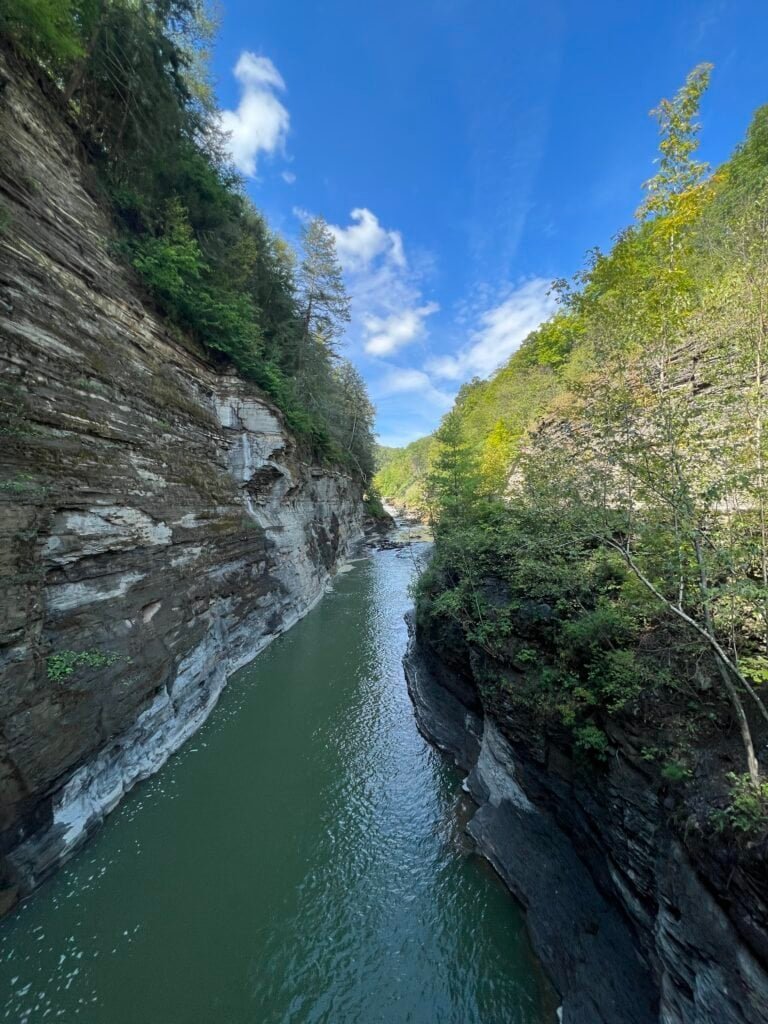
Pictures: Views from Starved Rock: Leopold Island No. 1 and The Dam

The path and boardwalk will take you parallel to the river where you will come upon Lover’s Leap Overlook and then the Eagle Cliff Overlook. Both of these overlooks offer similar views of the Illinois River and the Eagle Cliff Overlook gives you a closer look at The Dam.

Pictures: The Dam from Lover’s Leap | A closer view of the Dam | Looking East from Eagle Cliff

Now it off to the Canyons and Waterfalls. I started with Wildcat Canyon and Falls – one of the tallest falls in the park with an 80-foot drop. Unfortunately, it was full of school kids despite the trail map clearly saying, “Swimming and Wading Prohibited,” hence why I took a “waist up” picture of the falls and didn’t include the pool below. Don’t get me wrong, I am all for enjoying nature, but in this case, the park is worried about the long-term damage to the eco-system.

And as you continue through the park, you’ll also come across some amazing rock formations.

Picture: Wildcat Canyon Falls
Picture: One of the many amazing rock formations.

Next up, one of my favorite canyons – LaSalle Canyon. The falls aren’t as high as Wildcat, standing 25′ high, but the canyon is beautiful and I love that you can walk behind the waterfalls. And typically there is water here year round. Tonty Canyon can also be accessed as you go hike up the trail to LaSalle Canyon, however it was closed the day I visited the park.

Pictures: LaSalle Canyon and Falls

I continued down the trail as far as the Hennepin Canyon Overlook where I was able to get a great view of the overlook from below it, by the river.

Picture: Hennepin Canyon Overlook

Hennepin was as far as I could hike due to a trail closure, so I double backed to Lone Tree Canyon, then took the stairs up to the canyon rim. It’s cool to walk along the canyon rims as you get a different perspective of the canyons and waterfalls.

Pictures: The hike up Lone Tree Canyon and Lone Tree Canyon

Pictures: Views of the Canyons and Waterfalls from above.

Overall my hike was 6.6 miles and took 2 hrs. 5 min. with stops. I took a break back at the parking lot, refueled with a couple of energy bars and fortified water, then head down river to the canyons I wasn’t able to reach due to the trail closure.

I parked at the lot between Illinois and Ottawa Canyons. This too was definitely an interesting hike – to start – I ran into a local, walking barefoot and for some reason had to tell me he was headed back home as he thought he left the oven on. Ok? Then a group of guys started hiking in front of me with a boom box (as I mentioned earlier “city folk”), so I went down a different trail. And at one of the waterfalls, I took a picture of a group of older ladies from Wisconsin. They traveled a bit and gave me a wealth of information and some great recommendations for hiking in Wisconsin, the U.P. (Michigan’s Upper Peninsula) and Minnesota.

On this hike, I headed towards Ottawa and Kaskaskia Canyons, where you will first pass under the Council Overhang – an uber cool rock formation!

Pictures: Council Overhang

I decided to go up to Kaskaskia Canyon first. This waterfall is pretty short with a 15-foot drop, but it was peaceful (the boom box guys took a different trail) and quite beautiful.

Picture: Kaskaskai Canyon Falls

Ottawa Canyon Falls was next. This is one of the taller falls at 45′.

Pictures: Ottawa Canyon Falls

Picture: Ottawa Canyon Falls

I headed back and this time there was no one at the Council Overhang. So I got more pictures and took a goofy picture – making it look like I was hanging from the overhang. (well sorta). Despite the crowds, I enjoyed my visit to Starved Rock State Park.

Picture: Council Overhang

Pictures: Council Overhang | Me “Hanging” from the Overhang

Date of Visit: 19 May 2023

Bash Bish Falls State Park | Massachusetts

I have to be honest, after visiting Bash Bish Falls, I was somewhat disappointed. I guess up to this point I had been spoiled with some epic hikes and big parks with numerous activities, view points and sites. So fast forward – I have now visited 20 of the state parks on The Discoverer’s list of the Best State Park in Each State (yes I am behind in writing as Bash Bish is #8), and I’ve realized that there is something unique about each park. Not all parks have a ton of different activities, view points, and sites, nor are they all big. But if you seek out what makes the park unique and perhaps combine it with other parks/sites in the area, it will be worth the visit. This is especially relevant as I write about Bash Bish Falls State Park.

So, I had just finished a great hike at Mt. Frissell – the highest point in Connecticut and I was excited to visit Bash Bish Falls State Park. The park is 424 acres and the main attraction is Bash Bish Falls – the highest single-drop waterfall in Massachusetts – with a dramatic final pitch that drops about 80 feet into an emerald plunge pool. It is adjacent to the 4,000-acre Mount Washington State Forest, as well as New York’s 5,000-acre Taconic State Park – two places to add to your visit.

Picture: Park Map

I had done a little research and learned that the Massachusetts parking area was under construction, so I parked on the New York side – not the end of the world – but adds to the story.

Parking: Where you park determines your hike to the falls.

  • From Massachusetts Parking Lot: (When it reopens) Difficult ability (I can’t attest to this), about 0.6 miles round-trip. It’s shorter, more rugged, and strenuous per the park website.
  • From New York Parking Lot: Moderate ability (it’s really easy in my opinion), about 1.5 miles round-trip. It’s longer and gradual, but rocky and uneven per the park website.

Pictures: Views along the hike up to Bash Bish Falls

As you can see in the above pictures – more and more parks are asking that you refrain from stacking rocks or making cairns and rightfully so. This practice is disruptive to the environment – not only does it cause harmful erosion, but many insects and mammals head under rocks to live, reproduce or escape their predators. Now don’t get me wrong, people have been stacking rocks since the dawn of time, typically for directional or burial purposes. And more recently, park officials began creating them on hiking trails – especially potentially confusing paths – to help ensure hikers don’t get lost. But we shouldn’t be creating them for the sake of an Instagram post. Our future relies on a healthy natural environment and we need to abide by the motto – Leave no Trace!

Picture: Entering into Massachusetts and Bash Bish Falls State Park

The falls are beautiful and I really enjoyed hiking the gorge. It certainly was a relaxing visit and especially welcoming after a long hike up to Mt. Frissell.

Picture: Bash Bish Falls
Picture: Bash Bish Falls and the emerald plunge pool

Pictures: The deep, verdant gorge | Bash Bish Falls and the gorge

Picture: Back to New York

If you’re in the area, it’s definitely worth the visit and there are a ton of things to do in both the Berkshires and the Taconic Mountain Range.

Date of Visit: 12 May 2023

Liberty State Park | New Jersey

One of the State Parks that really surprised me was Liberty State Park | New Jersey. With the Manhattan skyline, Statue of Liberty and Ellis Island as a spectacular backdrop, Liberty State Park has got to be one of the state’s most dramatic parks. This 1212-acre State Park is one of newer State Parks – officially opening in 1976 to coincided with bicentennial celebrations. Much of the interior of the park is undergoing restoration due to hazardous material and severely contaminated land as much of the park is situated on landfilled tidal flats. But this shouldn’t be of concern and there is so much to enjoy at the park.

As many of you know, I am pretty passionate about making parks accessible to everyone, and Liberty State Park does not disappoint as there is no entrance fee. I parked at the Freedom Way parking lot and decided to visit the north end of the park first and then work my way south. Once past the parking lot and picnic area, you immediately see the dramatic Jersey City and Manhattan skylines.

Picture: Liberty State Park Map

Pictures: Jersey City skyline | Manhattan skyline with the North Cove in the foreground

The park has a rich history and you will find numerous monuments and memorials as you tour it. I first came across La Vela di Colombo, a two-story sail-shaped bronze monument designed by Gino Gianetti that commemorates the 500th anniversary of the westward journey of Christopher Columbus to America in 1492. The “Sail of Columbus” sits atop a stone base in the shape of a ship and features scenes of Columbus and his travels and was a gift from Government of Italy and the City of Genoa.

Picture: La Vela di Colombo

Next up – the historic Central Railroad of New Jersey Terminal (CRRNJ Train Terminal). From 1892 it was from this ferry/train station that two-thirds of all immigrants arriving at Ellis Island spread out across the US. And by the turn of the century, the CRRNJ Terminal accommodated between 30,000-50,000 commuters per day on 128 ferry runs and 300 trains. Still standing today are the Bush train sheds, housing 20 tracks and at the time the largest one ever built and the Communipaw Terminal, designed in a Richardsonian Romanesque style by architects Peabody & Stearns of Boston, Massachusetts and completed in 1889.

Picture: The Bush Train Sheds

Pictures: Historic Train | The Communipaw Terminal

As you come around the Bush Train Sheds, you are immediately struck by The ‘Empty Sky’ 9/11 Memorial. It’s the official State of New Jersey Memorial that honors the memory of the 750 people that lived in or had ties to New Jersey that lost their lives at the World Trade Center, the Pentagon, and Shanksville, PA on September 11, 2001

The names are placed randomly on the twin brushed stainless steel walls. Individuals’ names (4 inches tall) are within reach and engraved deep enough for hand rubbing. The memorial, designed by Jessica Jamroz and Frederic Schwartz, was dedicated on September 11, 2011, the 10-year anniversary.

The brushed stainless steel twin walls are 210 feet long, the width of each side of the World Trade Center Towers. They rise 30 feet, standing parallel to each other with a 12-foot wide paved path of bluestone between them. Like the World Trade Center, the stainless steel reflects the constantly changing light of day. The memorial invites visitors to literally and metaphorically look toward the empty sky in memory and look forward as a community.

Picture: The ‘Empty Sky’ 9/11 Memorial

Pictures: The ‘Empty Sky’ 9/11 Memorial

Picture: The ‘Empty Sky’ 9/11 Memorial

From the front of the CRRNJ Terminal, you can take a walk along the 2-mile Hudson River Waterfront Walkway. From the terminal you can also take a ferry to the Statue of Liberty and Ellis Island. As you walk along the waterfront, you will first pass Ellis Island then Liberty Island and the Statue of Liberty.

Picture: Ellis Island
Picture: Statue of Liberty and Liberty Island

At the southern end of the park is Black Tom Island and another monument – the Liberation Monument which commemorates the Holocaust and the role of the United States in preserving freedom and rescuing the oppressed. The memorial depicts an American soldier carrying a Jewish concentration camp survivor.

Pictures: The Liberation Monument

Picture: The Manhattan skyline with Ellis Island in the foreground

I finished up my visit with a walk through the Green Ring and Crescent Field. Liberty State Park is a great place for a run, to walk, to picnic and to enjoy spectacular views of the Manhattan skyline, Ellis Island and the Statue of Liberty. I would highly recommend a visit if you are in the area.

Date of visit: 11 May 2023

Picture: The Green Ring

Blackwater Falls State Park | West Virginia

Blackwater Falls lives up to its hype as one of the most photographed and visited sites in West Virginia! It was, yet again, the perfect “storm” of events – I stayed on site at the Blackwater Falls State Park Lodge, the leaves were starting to turn color, the hikes were amazing, and the scenery breathtaking.

Picture: Sign in The Lodge

About the Park – Located in the Allegheny Mountains, Blackwater Falls State Park is named for the amber waters of Blackwater Falls, a 57-foot cascade tinted by the tannic acid of fallen hemlock and red spruce needles. The falls, along with a few of the park’s other features like Elakala Falls, Lindy Point and Pendleton Point Overlook, are some of the state’s most photographed spots. Visitors can enjoy the scenic views year-round by taking the steps to the falls, using viewing platforms or hiking the 20 miles of trails the park has to offer.

Picture: Trail Maps and Sites

The Lodge was nice, comfortable and clean – it was originally built in the 1950’s and since then has been renovated. There is a restaurant called the Smokehouse – and as you can guess – heavy on meat, but even this pescatarian was able to navigate the menu. However, it was unfortunate that they were understaffed for the volume of people and the restaurant itself needs a makeover. The space is also very awkward and cavernous in my opinion.

Pictures: The Lodge | A King Room overlooking the Canyon

Pictures: Views from the back of The Lodge

The next day was dedicated to hiking. Elakala Trail was first hike – a modest 0.5 mile trail where you pass by Elakala Falls. The trail starts at the south end of Blackwater Lodge, bridges the upper section with a great view of Elakala Falls, continues along the canyon rim and ends at the main park road across from Balanced Rock Trail. And as a surprise to those who know me well, I did not check-in to win prizes. I must have been off my “challenge game” that day!

Pictures: The WV Waterfall Trail Challenge | Elakala Falls from the top

Picture: Elakala Falls

I continued on to Balanced Rock Trail – a 1-mile trail that is somehow marked as somewhat difficult to difficult by the park service – but I am not sure if I would go that far. The trail crosses Shay Trace and Red Spruce Riding trails, continues to Balanced Rock and ends near Cabin 13 and Park Forest Road. One of the things I learned about West Virginia is that the state flower is the Rhododendron and this was evident as I hiked Balanced Rock Trail – rhododendrons were everywhere. At the end of the trail there are a couple of surprise – a large Field of Cairns – if you build it, they will come – and of all things a pay phone. I guess because cell service is spotty, there’s an option to call home ET – provided you have exact change. Wow – two movie references back to back!

Pictures: Balanced Rock Trail

Picture: Balanced Rock

Pictures: The Field of Cairns

Picture: Phone home ET

From here, I took a short walk up Park Forest Road until it connected to Shay Trace Trail. If you go left on Shay Trace you will end up at the base of the sled run, and if you go right – which I did – you will end up back at The Lodge. Along this trail you’ll cross Shay Run – the stream that flows over Elakala Falls that will give you a real sense of the amber waters in the area. I finished this hike at The Lodge for a total distance for this hike 2.4-miles.

Picture: Shay Run

Next it was off to Lindy Point Overlook. I drove there from The Lodge and decided to stop by the Sled Run and Nordic Center. Although not much to see at the Sled Run and Nordic Center, it was cool to see both. Back in the car and up to the small parking lot at the Lindy Point trailhead. Lindy Point Trail is an easy 0.7 mile out-and-back trail that sits at 3,000 feet and ends up overlooking the Blackwater Canyon. It was a bit wet and muddy the day I was there, but well worth the drive and short hike as you can see by the spectacular views.

Pictures: Views from Lindy Point Overlook

Picture: Blackwater Canyon from Lindy Point Overlook

From Lindy Point, I drove back into the park past the Lodge to the parking area across from the maintenance area and the Gentle trailhead. Gentle Trail is a short – 0.25 mile out-and-back – paved path to an observation deck overlooking Blackwater Falls. You quickly realize why this park is so popular and why it is one of the most photographed places in West Virginia when you see the falls from the observation deck. You can also see the leaves had started to change and I can only imagine how amazingly beautiful this place would look in a couple more weeks when the leaves are in full color.

Pictures: The Gentle Trail | Blackwater Falls from the observation deck

Picture: Blackwater Falls

Next, I took a shirt drive across the canyon, over the Blackwater River – where the amber color is even more deep and intense – to the Trading Post parking lot.

Picture: The Blackwater River and its deep amber color

The Blackwater Falls Boardwalk Trail starts at the Trading Post parking area and leads to a stone patio and boardwalk more than 200 steps down to an observation deck beside Blackwater Falls. This is the main viewing area for the falls and you get a pretty awesome view of the falls. On the way back up, I stopped at the upper viewing area for another view of the falls, then took the trail to the left (not sure if it has a name) back up to the parking lot versus going up the stairs. The total distance for the loop is about 0.5 mile and you get a good aerobic workout on the way back up.

Picture: Blackwater Falls from the lower observation deck
Picture: Blackwater Falls from the upper observation deck

My next stop was Pendleton Point Overlook. It’s a short drive from the Trading Post parking lot, but as I felt like I was jumping in and out of the car, I decided to hike there. So I crossed the Blackwater Falls Road and up Picnic Acres Road to the Spudder Track Trail. In the winter time this trail is part of the beginner loop for cross country skiers. The trail goes behind the vacation-style cottages and by a picnic shelter, before you get to another parking area for Pendleton Point. It wasn’t the most scenic trail and only about 0.5 mile, but I did see some deer along the way.

Pictures: Someone has an itch | She didn’t like the fact that I interrupted her scratching

Finally it was out to Pendleton Point – a short 0.2 mile out and back trail. From Pendleton Point you get another breathtaking view of the canyon and you can see the Lodge across the canyon.

Pictures: Blackwater Canyon from Pendleton Point

Picture: Blackwater Falls State Park Lodge from Pendleton Point

The end of the hike was a bit anti-climatic as I walked along Blackwater Falls Road back to the Trading Post parking lot – about 0.5 mile. Total distance for this hike, including going down to the observation decks was 2.25 miles. All in all – a great experience, an amazing park and I’d highly recommend a visit!

Date of visit: 3-4 October 2022

Natural Bridge State Park | Kentucky

One of my favorite parks I have visited thus far is Natural Bridge State Park in Kentucky. I think alot had to do with it being the “perfect storm” of events – I stayed in the park at the Hemlock Lodge, there weren’t a ton of people there, I got up and went hiking early, and when I got to the Natural Bridge, I was the only person on the bridge! And seeing how popular this park is, I was lucky to have the solitude and serenity.

About the park: Tucked within the Daniel Boone National Forest, Natural Bridge State Park is a 2,300-acre park that features a magnificent, natural sandstone arch. The bridge spans an incredible 78 feet and reaches 65 feet high, towering over an area nicknamed, “Kentucky’s Land of Arches.” The park also highlights over 20 miles of hiking trails to famous Kentucky sights like Fat Man’s Squeeze, Balanced Rock, and Lover’s Leap.

My hike: My room overlooked the lake area, which intrigued me, so despite knowing that I was going to hike down hill and then back up to the lodge parking lot to the Original Trail – about a total of a 1/2 mile. I did it and I was happy as it gave me a chance to explore more of this beautiful park. At the parking lot, there were several signs about bears, and knowing I was hiking alone and that there were few people out hiking, I had a little trepidation, but went on. I have since better educated myself on bears and what to do and I also carry bear spray as a last resort.

From the parking lot, I continued up the Original Trail to the Natural Bridge. This is the steepest part of the trail with an elevation change of 420 ft. It is a beautiful hike through the forest surrounded by hemlock, tulip trees, white pines and thickets of rhododendron. And of course, I saw my favorite – mushrooms – and had to take a picture.

Pictures: Some of the rock formations on the Original Trail up to the Natural Bridge

Pictures: Mushrooms – the beauty of nature | The Original Trail

As you come to the top of the Original Trail, you come around a bend, and see the Natural Bridge for the first time. I was not prepared for how magnificent it was going to be and the closer I got to it, the more awe-inspiring it was. It always amazes me at the power of nature and what it can create. The trail continues up until you are right under the bridge. From under the bridge, there is a super – yes super – narrow walkway – next to the bridge – that takes you up to the top of the bridge.

Picture: My first glimpse of the Natural Bridge
Picture: The Original Trail as you come to the base of the Natural Bridge
Picture: Underneath the Natural Bridge
Picture: One of my favorite views of the Natural Bridge
Picture: And super cool in black and white

Pictures: More of the underside of the Natural Bridge

Pictures: The super narrow stairway up to the top of the Natural Bridge

The second WOW – being on top of the bridge. I wasn’t prepared for the magnificent views and to be on such a daunting structure – it was super cool. And I’ll be honest – with my slight fear of heights, it was a bit scary on top, but well worth it! It should be noted, and as you can see from the pictures, there are no guardrails up there – just some warning signs to be careful near the edge. There are stories of people being careless and falling off, so be careful on top. From the top of the Natural Bridge, you can see Lookout Point in the distance – where I am headed to next.

Pictures: My first view of the top of the Natural Bridge | The massive beauty of the bridge

Picture: The view from the top looking at Lookout Point

Pictures: The beautiful morning fog in the valley | Me on top of the world!

From the Natural Bridge I took the Laurel Ridge Trail (#9) – a hike along the rim of the cliffs, where you will eventually pass the Skylift – a chair lift taking people up to the top. The trail then winds out to Lookout Point – the sandstone cliff you could see from the Natural Bridge. From Lookout Point, you get more amazing views and you can look back at the Natural Bridge. There is quite a big drop off from the point, and again there are no guard rails, so be careful as you get near the edge. I took a moment and had breakfast on Lookout Point, taking in the beauty and enjoying the serenity nature has to offer.

Picture: The Skylift
Picture: Looking back at the Natural Bridge
Picture: Post breakfast selfie

The trail continues along the rim and it can be narrow at some points, with some step drop-offs. Next you will come to two, very steep, stairs – Devil’s Gulch and Needle’s Eye – both will take you down to Battleship Rock Trail (#3). However, I continued on the trail to Lover’s Leap – another overlook with breathtaking views of the canyon below.

Pictures: Views from Lover’s Leap

Lover’s Leap is a dead end, so after enjoying the views, I turnaround and headed back. I decided to go down Needle’s Eye – built in 1934 by the Civilian Conservation Corps – which is very steep – so I took my time going down. At the base of the stairs, you connect to Battleship Rock Trail (#3). I took the trail back towards the Natural Bridge and along the way you will pass Battleship Rock and other beautiful rock formations. And for the life of me, I am not sure why I don’t have a picture of Battleship Rock?

Pictures: Needle’s Eye

Pictures: The hike along Battleship Rock Trail

Back at the Natural Bridge, I connected to the Rock Garden Trail (#4) which winds around below the cliffs and eventually takes you back to the Hemlock Lodge. I am so happy I decided to take this trail as you pass by more spectacular rock formations.

Pictures: Rock formations along Rock Garden Trail

Pictures: More rock formations along Rock Garden Trail

I was glad that I started out my day early and that I did not check out as I was able to take a shower and change before check out time and before I hit the road again. The total distance for the hike was about 4 miles and took me about 2 hrs. as I stopped several times. I highly recommend a visit to Natural Bridge State Park in Kentucky!

Date of visit: 16 September 2022

Brown County State Park | Indiana

Brown County State Park is by far the largest State Park in Indiana encompassing nearly 16,000 acres. It’s nicknamed the “Little Smokies” because of the area’s resemblance to the Great Smoky Mountains with rugged hills, ridges and fog-shrouded ravines. Sorry, I didn’t see the resemblance, but none-the-less it is a beautiful park. I also realized as I am writing this, that I should have done more research on the park and area as I missed out on a lot that both have to offer. The park is located near Nashville, Indiana – a picture postcard of a town and an artisan community with over 200 galleries. And from the park’s website – the top five things to do:

  1. Climb the 90’ Fire Tower for a breath-taking view of the hills o’ Brown.
    • Didn’t do – and bummed as I have a slight fear of heights and always try to overcome this.
  2. See the rare (and state-endangered) Yellowwood tree on Trail 5.
    • Missed Trail 5 so didn’t see this.
  3. Visit the nature center to see the rare, state-endangered timber rattlesnake.
    • Missed this, and it would have been cool to see the rattlesnake.
  4. Jump in the Water Park pool, newly constructed at Abe Martin Lodge.
    • Missed this too.
  5. Watch a sunrise or sunset from a vista.
    • Since I was on a schedule, left before sunset.

Oh well, I guess I need to make another visit to the park to experience the top 5 things to do. I also didn’t know there was a 7-vista challenge, which I would have been all over as many of you know how competitive I am. (Funny, I just noticed as I was looking at the pictures of the West Lookout Tower, there is a sign on the frame noting this is vista #1 in the challenge – missed that entirely!) With all that said, I did enlist the help of AllTrails to find the best trails to hike. I started out on the HHC TRAIL, a moderate 3.6 mile trail, with an elevation gain of 482 feet, that extends east from west lookout, continues to near Hesitation Point, and then southwest to parking area at Ogle Lake and Trail 7, where I started my hike.

I first took the trail up to Hesitation Point, one of the most popular vistas in the park with its picturesque views. The trail then goes parallel to the road, which I never understand why trails go so close to the road as it seems counterintuitive to being in the outdoors hiking. But enough of my rant. The next vista is West Lookout Tower Vista. There is a two-story tower overlooking the valley and apparently is the perfect stop for a glorious Brown County sunset. It was fashioned after structures built for surveyors who were working in the area. Map makers lived in the upper level while horses and livestock were stabled below.

Pictures: The entrance to Brown County State Park near Nashville, Indiana

Pictures: Trail #8 trailhead | The trail up to Hesitation Point

Picture: View from Hesitation Point
Picture: West Lookout Tower

Pictures: The lower area for horses | View of the valley from the tower

Picture: Picture Frame noting this is Vista #1 in the Seven Vista Challenge

From the West Lookout Tower it was back down to the parking lot. I enjoyed this portion of the trail – away from the road through a beautiful forest and along a ravine. Once back to the parking lot, I decided to go around the lake on Trail #7 – a 1.2 mile loop with a slight elevation gain of 36 feet. (the Indiana Department of Natural Resources marks this trail as moderate, not sure why because they also mark trail #8 as moderate?) Ogle Lake is a 17-acre lake for fishing and boating. It was a nice hike and gave me some additional miles for the day.

As I was hiking trail #8 and then trail #7, I noticed all these temporary markers and wondered what they were for. Well near the end of my hike, I ran into a volunteer and found out that they were setting up for a major trail race – Dances With Dirt | Gnaw Bone. They tout it as the world’s most difficult 10K and you should expect double your road time and triple your effort! Sounds like fun? (actually it does as I love trail running) They also have a 5K, 13.1M, 26.2M, 50K, and 50M – yes a 50-miler!

Pictures: Ogle Lake | The marshy area at the end of the lake

Pictures: The area around the lake can be wet and marshy, so there are bridges and stumps to navigate

Picture: ✅ Another Best State Park in the books!

Date of visit: 18 May 2023

And on my way up to Illinois and Starved Rock State Park, I rewarded myself with some soft serve ice cream from the Dairy Bar in Lizton, IN – just northwest of Indianapolis.

Hocking Hills State Park | Ohio

In the few years I lived in Ohio, I never made it to Hocking HIlls State Park despite my colleagues and friends raving about it and camping there. And after visiting the park, I can see why there was so much hype about it! It’s a gorgeous park with over 25-miles of hiking trails, spectacular rock formations, beautiful waterfalls and amazing recess caves. There is a ton to see and I would highly recommend you dedicate at least one full day to the park. The park is definitely very busy during peak times, but I found that the further into the park you hike, the less people you will come across. With that said, I would still recommend visiting during an off-peak time, so you can really enjoy the park’s beauty.

I took the Gorge Overlook Loop via the Buckeye Trail which is 6.3 miles with a modest elevation gain of 429 feet and it will take you at least 2 hrs. 15 minutes (more if you take your time at the different sights along the way). I also added an out-and-back to Whispering Cave which adds another 1.0 mile, has a pretty good elevation gain of 300 feet, and it was definitely worth the extra time (probably another 30-minutes). It should also be noted that many of the trails in the park are one way.

The first area to explore is the Old Man’s Cave area which is broken up into five principal sections – Upper Falls, Upper Gorge, Middle Falls, Lower Falls and Lower Gorge. Old Man’s Cave got its name from the hermit, Richard Rowe, who lived in the large recess cave of the gorge. His family moved to the Ohio River Valley around 1796 from the Cumberland Mountains of Tennessee to establish a trading post. Interesting note – Richard is actually buried beneath the ledge of the main recess cave and his two brothers are also buried in the same area.

Being so close to the parking lot, the Upper Falls area is one of the busiest parts of the park you will encounter.

Picture: Upper Falls

Next you’ll come across The Devil’s Bathtub – a unique, tiered waterfall between the Upper Falls and Old Man’s Cave. The tub is situated in a weak layer of Black Hand Sandstone and is constantly enlarged by the swirling action of Old Man’s Creek. Although the pool is rumored to extend deep into the depths of Hades, it’s only a few feet deep!

Picture: Devils Bathtub

Pictures: A couple of the incredible rock formations

As you make your way through the gorge, you will crisscross Old Man’s Creek. I found the new concrete Step Bridge pretty cool and fun to walk over. These steps are below the A-Frame Bridge that you’ll cross near the end of your hike.

Pictures: The New Step Bridge | Rock Formation

The area around Old Man’s Cave can be a bit confusing with the one way trails, entrances and exits. But I was able to navigate it, although I think I went out the entrance to get back to the main trail. I found the tunnel to get their uber cool and the cave to be jaw droppijng at how expansive and beautiful it was. The Middle Falls are right by the cave. From here I resumed my trek south to the lower falls.

Pictures: Middle Falls and Old Man’s Cave | Tunnel to the Old Man’s Cave

Pictures: Old Man’s Cave

Picture: Lower Falls

I found that once I got past the Lower Falls, the crowds thinned out a quite a bit. Not that it was super crowded the day I was there, but relative to the Old Man’s Cave area, the rest of the hike had minimal people. From the Lower Falls, you head south and you will continue to see amazing rock formations.

Pictures: More amazing rock formations

At the southern end of the park, you have a choice, you can head west on the Hemlock Bridge Trail to the Whispering Cave Trail or continue east on the Buckeye Trail. I decided to check out Whispering Cave and I am so happy I did. Out and back is a mile and there is a bit of an elevation gain on this trail. It should be noted that the Hemlock Bridge Trail is ONE WAY and takes you all the way back to the Visitor Center after Whispering Cave. So before you decide to do this side excursion, read my note below – it’s after the pictures of Whispering Cave. Once on the Hemlock Bridge Trail you will cross a small foot suspension bridge. I personally think elements like these really make hiking fun and unique.

Picture: Food Suspension Bridge

As you climb up towards Whispering Cave Trail you’ll pass some incredible Honeycomb Weathered Sandstone. There are many theories on what causes the honeycombs and currently it is considered to be polygenetic in origin; being the result of complex interaction of physical and chemical weathering processes, which include salt weathering and cyclic wetting and drying.

Picture: Honeycomb Weathered Sandstone

Eventually you will come to the Whispering Cave Trail – a short out-and-back trail to Whispering Cave.

Pictures: Entrance to Whispering Cave | View looking out of Whispering Cave | Inside Whispering Cave

So here is my note regarding taking the Hemlock Bridge Trail: Now, I realize this is wrong and I hopefully won’t get any hate mail for this, but as it was not too busy at the park and I passed people going in the wrong direction on the Hemlock Bridge Trail, I went back down the Hemlock Bridge Trail to the Buckeye Trail. I.e. I too went in the wrong direction on this short section (0.3 mile) of the Hemlock Bridge Trail. I was respectful and gave everyone going in the right direction, the right of way.

Along the southern section of the park, you will come across some amazing trees and see the magnificent gorge walls. Eventually you will reach Whispering Falls. Whispering Falls doesn’t consistently flow (as was the case when I was there) and is a narrow plume of water that shoots off the towering rock face into Queer Creek gorge below.

Pictures: One of the many trees growing on the rocks | The steep walls of the gorge

Pictures: Natural Tunnel formed by a giant block leaning against the cliff | More of the magnificent walls of the gorge

Picture: Whispering Falls (or not)

The trail along the southern portion of the park is spectacular and well worth the hike. There are small waterfalls and more amazing rock formations. Eventually you will reach Cedar Falls – another very popular spot as there is a parking lot nearby. Cedar Falls itself is the greatest waterfall in terms of volume in the Hocking region. Queer Creek tumbles over the face of the Blackhand sandstone displaying the awesome force of water power.

Pictures: Rock Formation | Small Waterfall

Pictures: More Rock Formations

Picture: Cedar Falls

From the base of the gorge, you proceed up a long flight of stairs and will see signs for the Suspension Bridge. It’s a cool bridge adorned with a decorative piece at the top – a representation of one of the park’s geological features known as “The Sphinx.” From here you will continue along a ridge – overlooking the gorge below – then up to Rose Lake.

Pictures: Suspension Bridge | Rose Lake

Going to Rose Lake is a little bit of a detour, but you don’t have a choice due to the valley and stream that runs from the lake to the cliff above Queer Gorge. Once you cross the Rose Lake Dam, you head back south to the rim of the gorge and follow it west, then eventually north back towards the Visitor Center. This part of the trail is wooded and has a vibe than the gorge below. One of my many finds were some mushrooms, not edible, but I am always fascinated by the beauty of mushrooms.

Picture: Mushrooms on the trail above the gorge

You finish up your hike crossing the A-Frame bridge with views of the gorge below. And for the life of me, I am not sure why I don’t have a picture of the bridge? I only have a picture from the bridge, looking down on the gorge below. Perhaps my phone battery was dying as I was tracking my entire hike on an app.

Date of visit: 13 September 2022

Picture: View of the Gorge below from the A-Frame bridge
Misty waterfall cascading over layered rock formations along the Falls Trail at Ricketts Glen State Park in Pennsylvania

Ricketts Glen State Park | Pennsylvania

22 Waterfalls on One Incredible Loop

Of all the Best State Parks I’ve visited so far, Ricketts Glen State Park easily ranks as one of my favorites—and it’s a place I’d recommend making a special trip to see. Located about an hour west of Scranton, Pennsylvania, Ricketts Glen is one of the most scenic areas in the state.

The park spans 13,193 acres, features 22 named waterfalls, and offers more than 26 miles of trails. The star of the show is Ganoga Falls, plunging 94 feet, the tallest waterfall in Pennsylvania. Interestingly, when funding fell through during World War II and Ricketts Glen didn’t receive National Park designation, Pennsylvanians stepped in and purchased the land themselves, ensuring it would be preserved. Kudos to those who had the foresight.

Upper Falls at Letchworth State Park overlooking the Genesee River in New York

Letchworth State Park | New York

This is my first park to visit from The Discoverer’s list of Best State Parks in Each State. As I visit each state park, I will give you my thoughts, experiences and helpful hints.

Letchworth State Park, renowned as the “Grand Canyon of the East,” is one of the most scenically magnificent areas in the eastern U.S. The Genesee River goes through the gorge over three major waterfalls between cliffs–as high as 600 feet in some places–surrounded by lush forests. Interestingly, when we visited the park, the water levels were very low as you can see by many of the pictures. We spent two days in the park, which I would highly recommend.

Photos: History of the Park | It certainly is a great park!

Upper Falls at Letchworth State Park overlooking the Genesee River in New York

Best State Park in Each State

As many of you know, I follow a travel blog called The Discoverer. They tout themselves as A Modern Travel Guide that transports you to far off destinations directly from your inbox. I enjoy reading the articles on my quest to discover the world. One such article listed the Best State Park in Each State. The writer Morgan Love, doesn’t say how each park was selected, but non-the-less, I thought it would be fun to visit each park and give you my take on the park. The impetus of the article is to pay tribute to our beloved State Parks as State Parks are giving National Parks a run for their money, drawing an average of 807 million visitors annually. And why the hype – well, for one, each state has a ton of protected land with State Park designation — a whopping 18,694,570 acres, to be exact. With 8,565 parks and 14,672 trails to explore, chances are there’s a beautiful park right in your backyard. But if proximity isn’t enough to entice you, our State Parks are also known to offer the same amount of grandeur, history, and natural beauty as any other wild place in the states.

So follow along and be transported to these State Parks!

Page 4 of 4

Powered by WordPress & Theme by Anders Norén