My Visit to Stowe | Vermont
In my previous post about Mount Mansfield, I mentioned that the weather was not ideal for camping, and hotel rooms were expensive. As a result, I decided to stay in a hostel named Round Hearth Cafe and Market in Stowe, which I booked through Airbnb. Christopher, the host, was extremely friendly and an excellent host at the cafe as well. Additionally, the stay included complimentary coffee and a discount on food at the cafe. The hostel is not luxurious and is mainly intended for skiers, as indicated by the industrial carpet in the hallways (suitable for ski boots and snow). The rooms are plain but comfortable, and the shared bathrooms are super clean and well-lit. Since it was the off-season, I felt like I had the entire place to myself.


Pictures: Entrance to the Cafe and Hostel | Outdoor Seating Area


Pictures: Stairway to Rooms | Upper Hallway


Pictures: Hostel Room | Men’s Bathroom
That night, I decided to check out the area and found the Idletyme Brewing Company which was just down the road. I hung out in the bar area and had a chat with some of the locals. We talked about what to order for dinner and what to see at Smugglers Notch State Park. But then, an ambulance went by and they told me something creepy – apparently, the locals think someone has fallen at Bingham Falls every time they hear an ambulance. On that happy note, I had a great time and the food was pretty good.


Pictures: Idletyme Brewing Co. | Doubletyme IPA 7% | Fish and Chips
Work First, then a Hike
The next morning I had to do some work for a client, so I had breakfast in the cafe downstairs and worked on my project. It took a bit of time to complete, but there was still some daylight and I decided to head to the dreaded Bingham Falls – only a 5-minute drive up Mountain Road to the Trailhead.


Pictures: The Double Diamond Breakfast Sandwich with Avocado and Home Fries | The Cafe Interior


Pictures: The Round Hearth | Round Hearth Cafe Interior
First, a little about the park
Nestled in the heart of Vermont, Smugglers Notch State Park is a nature lover’s paradise that seamlessly blends breathtaking landscapes with outdoor adventure. Spanning over 1,000 acres, the park is a haven for hikers, boasting an extensive trail network that caters to all skill levels. Towering cliffs and dense forests create a picturesque backdrop, offering a serene escape from the hustle and bustle of everyday life. The park’s crown jewel, the famed Smugglers Notch, is a scenic mountain pass that weaves through rugged terrain, providing an exhilarating journey for those seeking a challenge. Visitors can relish in the park’s rich history, discovering tales of smugglers who once navigated these hidden paths. Whether you’re a seasoned trekker or a casual stroller, Smugglers Notch State Park invites you to explore its vast beauty and uncover the secrets held within its sprawling expanse.


Pictures: Trail Map | Trail Descriptions
There’s a reason it’s called Smugglers Notch
In 1807, President Thomas Jefferson passed an embargo act forbidding American trade with Great Britain and Canada. This was a severe hardship for northern Vermonters since Montreal was closer than other markets in the US. Many local people continued illegal trade with Canada, herding cattle and carrying other goods through the Notch. Later, fugitive slaves used the Notch as an escape route to Canada. During the Prohibition years, liquor was smuggled from Canada over the improved road built in 1922.
Top 5 Things to See
- Smugglers Notch: The iconic mountain pass itself is a must-see. Marvel at the breathtaking rock formations and immerse yourself in the rich history of the area, where 19th-century smugglers once navigated through this hidden gem.
- This is not hard to miss as the road runs right through the notch.
- Sterling Pond: Hike to the pristine Sterling Pond, the highest trout pond in Vermont. Surrounded by mountains, this alpine lake offers a serene setting for picnics and a chance to connect with nature.
- Compete – more later in the post.
- Bingham Falls: A natural wonder awaits at Bingham Falls. Cool off in the refreshing cascades and pools, surrounded by lush greenery. It’s a perfect spot for a rejuvenating dip after a day of hiking.
- Despite the warnings – I checked this off the list.
- Long Trail: Traverse a section of the famous Long Trail, which runs through the park. Whether you’re an avid hiker or a casual walker, the trail provides stunning views of the Green Mountains and an opportunity to explore the park’s diverse ecosystems.
- Although I didn’t do the entire Long Trail, I did portions near the Chin (see my Mount Mansfield post) and near Sterling Pond.
- Moss Glen Falls: A short drive from the park, Moss Glen Falls is a picturesque waterfall worth visiting. Surrounded by lush foliage, it’s a photogenic spot and a tranquil setting to appreciate Vermont’s natural beauty.
- Not to be confused with the Moss Glen Falls near Hostel Tevere that I wrote about in my Mount Mansfield post. I didn’t go to this particular Moss Glen Falls.
Let’s Conquer the Falls!
With my work complete, I decided to get a late afternoon hike in and headed towards Bingham Falls. The falls are named after Hiram Bingham, an American missionary, explorer, politician, and early settler in the area. It was carved by glaciers during the last Ice Age and has been a local favorite for cooling off and unwinding for generations. The park has numerous educational signs and well-marked trails, including those at the falls.


Pictures: Some of the educational signs you’ll discover
From the parking lot off Mountain Road, the trail is just a short 0.8 miles out and back. There’s a bit of elevation change, with the biggest challenge being the descent to the base of the falls. It’s a beautiful walk through the forest, which leads to the Upper Falls area. From there, there are steps down to the base of the falls. As I explored the area, I realized why people often get hurt or even die here – the rocks are incredibly slippery and there are no fences to prevent accidents. Therefore, it’s important to take your surroundings seriously and be cautious. I can only imagine how many people have been injured while trying to take a “cool” pic for Instagram.


Pictures: The initial portion of the trail


Pictures: The Upper Falls area


Pictures: Upper Falls


Pictures: The steep and slick trail down to the base of the falls
Trail Therapy
As I headed back to the parking lot, I decided to take a hike along the river. While on the trail, my attention was drawn to a young woman seated by the riverbank, immersed in her thoughts with headphones on. Respecting her space, I continued cautiously. Eventually, reaching the trail’s end, I retraced my steps. This time, our eyes met, and she removed her headphones. Greetings were exchanged, and I sensed an unease. As we chatted, she confided in me about her health struggles, likely stemming from mold in her flood-affected apartment, a result of recent Vermont floods. With empathy, I shared some fatherly advice, ranging from seeking legal assistance to moving out or finding a roommate. Encouraging and positive, I ensured she felt supported before I left her. This situation echoed a moment near my sister’s home, where a stranger stopped, concerned about my well-being – not that I looked distraught – but due to a recent suicide at the nearby falls. Compassion is priceless, reminding us to be attuned to others and their experiences. I believe fate guided me on that trail, and I sincerely hope she found a solution to her challenges.
Boxed Wine, Cheese and Crackers
After an emotional finish to the day and having successfully survived the hike to Bingham Falls, I headed to the market to buy some cheese, crackers, and boxed wine for dinner. Yes, I am a fan of boxed wines and have found some really good ones. In fact, years ago, I went to an incredible restaurant in France that only served boxed wine. So, I set up a spot outside at one of the cafe’s outdoor tables and enjoyed the sunset before heading to bed as I had a big day of hiking ahead of me.
Hiking: Day 2
The next morning, I packed up and headed out for a day of hiking. I had hoped to get out early, but had to tend to some business before hiking as I knew cellphone coverage would be spotty in the mountains. With my business finished, I headed to the Smugglers Cave parking area where I would first head to Sterling Pond and then Smugglers Cave. For a Tuesday with overcast weather, the parking lot was filling up fast, but I was fortunate to get a spot. I stopped at the information booth and spoke with the volunteer about the trails and such. He was a super interesting guy who had been a ranger in the Adirondack Mountains.


Pictures: Boulders at the Parking Lot | Overcast Weather
A Steep Climb and Lookout for Bears
The trail up to Sterling Pond is a moderately challenging route – keep in mind you are hiking up a trail to a peak that people ski down. The Sterling Pond trailhead is across the street and the trail is 2.1 miles out and back to just Sterling Pond with an elevation gain of 1000 feet – with most of the gain at the beginning of the hike. And just like Bingham Falls, the rocks were wet and slick, lending to a slower-than-normal hike.


Pictures: Sterling Pond Trailhead


Pictures: The steep and slippery hike to Sterling Pond


Pictures: More of the steep incline | One of the “pop-up” waterfalls and streams along the trail
At the top of the mountain, you reach a portion of the Long Trail – the same Long Trail that connects the Chin to the Nose to the Forehead on Mount Mansfield. The entire Long Trail spans 272 miles from Massachusetts to the Canadian Border and was the first long-distance hiking trail in the U.S. Although this portion of the hike wasn’t too steep, it was sheer rock and super slick due to the wet weather.


Pictures: Joining the Long Trail | Warning Sign | Slick Rocks
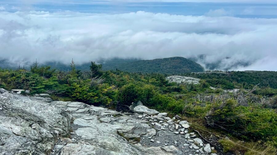
I hiked up to Sterling Pond, which is the highest-elevation trout pond in Vermont. It was a peaceful and beautiful spot, that is until a loud family could be heard in the distance. I continued my hike around the pond. The loop trail is about 1.4 miles long and includes some narrow sections and a few inclines, but nothing too difficult to navigate. The beginning of the trail was a bit challenging because some parts had been washed out, but I managed to make my way through. At the top of the ski mountain, which was still wet and swampy from recent rains, I checked out the chair lift platform, which was pretty cool. The trail around the pond wasn’t always easy to follow, and I ended up wandering around the summit a bit until I found a clearing and the trail again.


Pictures: Washed out Trail | View of Sterling Pond


Pictures: Ski Trail Sign | Top of the Notch Lodge


Pictures: Chair Lift Platform | Where the trail continues – through the opening in the trees
Shortly after I re-entered the woods, I came across a picnic table and a couple enjoying their lunch. I think I startled them as there were few hikers in this area. From here I headed down the Elephant’s Head Trail and this is where things got a little interesting. To begin with, it was super quiet and I was the only person on the trail. Then the initial part of the trail, along Sterling Pond, is quite narrow and there are a series of small inclines and declines through narrow rock gorges. It wasn’t anything I couldn’t navigate, but challenging at a couple of points.


Pictures: Elephant’s Head Trail Marker | The “loud” family that was behind me – now off in the distance


Pictures: One of the narrow gorges to maneuver through | The beauty of the forest
After you leave the area around the pond, there is another intersection and you continue on the Elephant’s Head Trail, which now takes you through the forest. From here it is an uphill climb, then back down. It was at this point that I began to see tracks in the mud. I had seen several dogs on the way up to Sterling Pond, but these were much bigger than the average dog. I suspected they were bear tracks! As a note: When I got back to the parking lot, I showed the ex-ranger and volunteer my photos of the tracks and he confirmed that they were bear tracks. I’m glad I was hiking with my bear spray! Eventually you connect back to the Long Trail.


Pictures: Back to the Long Trail | The Long Trail – heading towards Sterling Pond Trail
Once I got back to the Sterling Pond Trail, I headed back down the mountain to the parking lot. Along the way, I ran into a guy who was taking pictures of birds. He said it was a quiet day and he hadn’t seen many birds, but what I thought was cool – he was there on his lunch break from work. How cool to have this in your backyard and hike on your lunch break!
Looking for Smugglers!
After returning to the parking lot, I unloaded my backpack and poles and took a break to eat and drink. The weather was improving and the area was getting busier with more cars waiting for parking spots. Once I finished my lunch, I went back to the information booth to ask about the bear tracks and to get more information about the Smugglers Cave. I was happy to find out that the cave was located right behind the booth and there was a short loop up and around the caves. The cave was quite interesting, and I could imagine smugglers hiding out there in the past. It was a great way to end my day. I am happy that I split my visit into two days, as there is so much to explore and enjoy at Smugglers Notch State Park! I would definitely recommend a visit to this beautiful park.


Pictures: To Smugglers Cave | The History of Smugglers Notch


Pictures: Smugglers Cave

Time for a Beer
With the day relatively young, and Burlington, Vermont close by, I headed east to check out their craft brewing scene and to see a town I have been wanting to visit for some time. My first stop – Queen City Brewery – where I enjoyed a flight of beer and met a nice couple from the West Coast of Florida. We chatted about Florida Breweries and I mentioned my love for IPAs. They suggested I try Zero Gravity Brewery across the street as are known for their IPAs.


Pictures: Queen City Brewery


Pictures: Beers of the Day | My Flight of Beer
After finishing my flight, I headed across to the street to Zero Gravity Brewery where I picked up a few different IPAs in cans. With beers in hand, snacks in my cooler, and the golden hour approaching, I headed to nearby Oakledge Park to see the sunset on Lake Champlain. I sat on the rocks and watched an incredible sunset. It was a great way to end an incredible day!


Pictures: Waiting for Sunset | Ferry crossing Lake Champlain


Pictures: Spectacular Sky | Beauty on the Rocks


Pictures: Golden Hour over Lake Champlain

Dates of Visit: 11 and 12 September 2023