sharing my love for philanthropy, cooking, and adventure

Sunrise illuminating the summit glacier on Mount Kilimanjaro, with ice formations in the foreground and a sea of clouds in the background.

Tag: wanderlust Page 5 of 6

Lake Murray State Park | Oklahoma

As I headed westward from Louisiana to San Diego, I stopped at Lake Murray State Park in Ardmore, Oklahoma. I went via Dallas, Texas, and didn’t even recognize the city I used to live in. From the explosive growth came a concrete jungle with highway interchanges as tall as skyscrapers and strip malls covering every inch of land from Dallas to to Denton – some 40 miles. Lake Murray State Park is located about 1/2 way between Dallas, Texas, and Oklahoma City, Oklahoma, just off Interstate 35 and about 10 minutes from the center of Ardmore, Oklahoma.

Picture: Northern Park Entrance at US-70 and Route 77S

About the Park

Named after Oklahoma Gov. William “Alfalfa Bill” Murray, Lake Murray State Park comprises a 12,496-acre recreational area and a 5,728-acre, man-made lake created by the damming of the Fourche Maline and Anadarche creeks. Lake Murray’s crystal-clear spring-fed waters and 150 miles of shoreline welcome a variety of outdoor recreation opportunities including hiking, biking, boating, fishing, and camping. There is a $10 fee per day to park anywhere in the park that you pay through an app or you can pay cash at the park office. You’ll see signs at every parking lot, but only need to pay once per day.

Lake Murray State Park is the first and largest state park in Oklahoma and was constructed during the era of Pres. Franklin Roosevelt’s New Deal and part of several New Deal Agencies including the Civilian Conservation Corp or CCC, which I have written about in my past blogs about other state parks; and the Works Progress Administration or WPA. The solons envisioned the park as a relatively cheap recreational environment for the citizens of Oklahoma (I beg to differ with a $10 parking fee). Two main group camps were created, along with a “Negro” camp. Lake Murray State Park became the only state park built by the National Park Service to provide permanent camping facilities for black youth.

Staying at the park is easy with your choice between RV and tent campgrounds, 56 cabins dotted throughout beautiful Lake Murray State Park, and The Lake Murray Lodge with 32 rooms. The Lodge has a restaurant, an outdoor pool, a splash pad area, and a miniature golf course.

Pictures: Northern Park Map | Southern Park Map

Top 5 Activities at Lake Murray State Park

Lake Murray State Park is definitely a destination for boating and water activities, as well as camping. My impression was that it’s more of a “resort” and not the woodsy, outdoors, and rustic parks that I personally prefer to visit. This particular list of activities is ranked in what I feel are the common uses for the park.

  1. Boating and Water Activities: Lake Murray is a large reservoir, and visitors can enjoy boating, fishing, swimming, and other water activities. The park has boat ramps, a marina, and designated swimming areas.
  2. Camping: For those looking to extend their stay, Lake Murray State Park offers camping facilities. Whether you prefer tent camping or RV camping, there are options available within the park.
  3. Golfing: Lake Murray State Park features an 18-hole golf course known as the Lake Murray State Park Golf Course. Golf enthusiasts can enjoy a round of golf surrounded by the park’s picturesque scenery.
  4. Visit the Tucker Tower Nature Center: Tucker Tower is a historic structure located within the park that now serves as a nature center. It was originally designed to be a summer home for the governors of Oklahoma and today it is the home of the Nature Center and providing educational exhibits about the area’s natural history and offering panoramic views of Lake Murray.
  5. Hiking and Nature Trails: Explore the natural beauty of the park by taking advantage of its hiking and nature trails, which span over 30 miles in total. These trails offer a chance to see local wildlife and enjoy scenic views of the lake and surrounding landscapes.

Let the Driving Tour Begin!

I spoke with the receptionist at my hotel in Ardmore and she gave me some good recommendations on the sights to see which included the Fishing Pier and Tucker Tower, but added that Tucker Tower was currently closed for repairs. After breakfast, I headed out to the park, entering from the north entrance by the Lake Country Store, then taking Route 77S, the scenic highway around the park and lake. I did find it odd that the speed limit on 77S is 45 mph, which I thought was fast and not conducive to enjoying your drive around the park.

Before I continue, I wanted to give you some background and context on my visit. I felt as if Lake Murray State Park is best explored if you are staying there for a couple of days, which I did not do. I also think having access to a boat is key to fully enjoying the park, which I did not have. I personally love hiking, and to be frank, outside of my jaunt to Buzzards Roost, I didn’t find the trails very interesting. I also think that because my visit was in November, there wasn’t a lot open at the park and it lacked energy from having people around. So hopefully that will help if you are looking to visit the park.

With that said, I first stopped at the Pecan Grove Picnic Area, and yes, you have to pay to park here. It is a typical picnic area and there is a trail that you can take back north to the Lake Country Store and along the lake.

Pictures: Pecan Grove Picnic Area

Pictures: The trail at Pecan Grove Picnic area

Next up was the North Boat Ramp, where you get your first view of the lake. I had to laugh as I pulled into the parking area and saw a parking enforcement officer in his car, which I certainly didn’t expect to see, especially on a quiet Monday. So I guess they take their parking fee seriously.

As I continued south, Dukes Forest Campground was next, but it was closed for the season. Shortly after this, there is a small parking area and the Johnson Memorial Bridge, an arched bridge named in honor of E.J. Johnson, project superintendent for the CCC work projects here at Lake Murray.

Pictures: Memorial Bridge | Large Boulder by the Bridge | Plaque about the Bridge

Next, I took Gatehouse Road towards the lake, which will take you to several camping areas and sights – Elephant Rock Camp, Cedar Point Camp, and Tipp’s Point Boar Launch. Gatehouse Road also dead ends into a parking lot with a view of the lake. As I drove through this area, I saw the only wildlife on my tour, some deer.

Pictures: Lake Murray from Elephant Rock Campground

The Lake Murray Lodge

Lodge Road, the western park entrance, is next on the tour. At the intersection of Route 77S and Lodge Road is one of the Park Offices, which to my surprise was closed. As you drive towards the lake, you’ll first pass some of the park’s cabins and then you’ll arrive at The Lake Murray Lodge – home to an outdoor pool, miniature golf, and a water sports rental center. There are also floating cabins nearby. As you leave the area, you’ll pass the Historic Water Tower, vital to the park’s cabins and lodge during their initial years of operation.

Pictures: One of the Cabins | The Lodge’s Outdoor Pool

Pictures: Miniature Golf Course | Water Sports Rental Center

Pictures: Lake Murray Lodge

Pictures: The Historic Water Tower

Some of the Water Activities

The Fishing Pier, recommended by the hotel receptionist, is right after the Lodge Area. For the record and as I know it, a pier is built out into the water, while a bridge crosses the water from shore to shore. Sorry State of Oklahoma, this is a bridge and not a pier. I walked across the “pier” as I wanted to hike some of the trails in the park, only to find a yellow stake in the ground, a trail guide of sorts, that was hardly legible and written with a Sharpie. Really?!

I ended up hiking about 1/4 mile and as I was unsure where the trail went, I turned back and went up another trail along the water’s edge. From here I got a nice view of the “pier” and the cove. This trail wasn’t well marked, so I turned around and headed back to my car. On my way, I ran into a woman with a strong accent, either Eastern European or German, walking her dogs. She stopped me to see if I knew about the trails and where this trail went. I told her that the Park Office was closed and I wasn’t able to get a trail map. With that she pulled out the maps she got from the Park Office – they were detailed topographic maps, that were so small you needed a magnifying glass to read, and so detailed you needed a PhD in Rocket Science to decipher them. I think the State needs to hire me as a Park Consultant.

Pictures: Sign at the Parking Lot | The Fishing “Pier”

Pictures: Trail Guide? | View of the Cove and Lake

Picture: The Fishing “Pier”

The Marina

Lake Murray Marina currently features 352 boat slips which should not be a surprise as boating is probably the number one feature of the park. The marina is accessible from Boat Dock Road and a portion of it is accessible from Buzzards Roost. For those wanting to just enjoy the water, there is the Lake Murray Marina Beach. From the marina, you also get a direct view of Tucker Tower Nature Center. This happened to be my only view of the infamous Tower as the road to the tower was closed on the day of my visit.

Pictures: The Marina

Pictures: My only view of Tucker Tower | The Entrance to Tucker Tower Nature Center

Picture: Tucker Tower Nature Center with the Marina in the background

The Best for Last

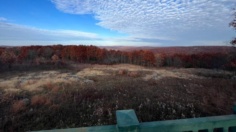
Buzzards Roost Road ends on the south side of the Marina. Along this road, you’ll see one of the original CCC Picnic Pavillions, constructed of large timbers and native stones. Next to the Buzzards Roost Campground, there is a small parking lot and the remnants of a cabin or building. To the right of the building is a set of stone stairs that will take you up to the Roost. Once on top, you can hike to either the left or right. I went in both directions and eventually found openings in the rocks where I had the most incredible and magnificent views of the lake and surrounding area. You can tell hiking, especially up and through rocks, is my jam!

Pictures: CCC Picnic Pavillion

Pictures: Building Remnants

Pictures: Some of the Stairs to the Roost

Pictures: Trail along the Roost | Selfie on the Roost

Picture: View from the Roost

Pictures: Views from the Roost

I finished my tour with a stop to get a view of the lake from a higher elevation, then a stop at Rock Tower. Overall it was a nice and interesting park that I would probably visit if I lived in the area, but I certainly wouldn’t list it as a destination park or a park I would make a special trip to.

Pictures: Lake Murray | Rock Tower

Date of Visit: 14 November 2023

Driskill Mountain summit sign showing elevation 535 feet in Louisiana

Driskill Mountain | Louisiana (#26)

After summiting Mount Magazine | Arkansas (#25) the day before, I continued my journey south into Louisiana and on to Driskill Mountain.

Driskill Mountain holds the distinction of being Louisiana’s highest natural summit, standing at 535 feet above sea level. It ranks #48 in State High Points — and it was my 26th High Point.

Located in northern Louisiana within the Kisatchie National Forest, it’s about 60 miles east of Shreveport and just 18 miles south of Interstate 20.

Panoramic view from Mount Magazine State Park overlooking the Arkansas River Valley with fall foliage and layered mountain ridges.

Mount Magazine State Park | Arkansas

Since Mount Magazine and Signal Hill (the highest natural point in Arkansas) are both located within Mount Magazine State Park — which is on my list as the Best State Park in Arkansas — I decided to cover them together in one blog post.

You can read the full write-up here:
Mount Magazine | Arkansas (#25)

Photo: Mount Magazine State Park Entrance Sign – Arkansas

Catch you on the trail!

Date of Visit: 12 November 2023

Wooden sign at Mount Magazine Signal Hill marking elevation 2,753 feet, the highest point in Arkansas.

Mount Magazine | Arkansas (#25)

And Mount Magazine State Park

Since Mount Magazine / Signal Hill sits inside Mount Magazine State Park — which is on my list as the Best State Park in Arkansas — I decided to combine both into one post.

The park is about 2 hours west/northwest of Little Rock, roughly 1 hour 15 minutes east of Fort Smith, and a little over 2 hours south of Bentonville — home of Walmart, for you trivia buffs.

Panoramic view from Taum Sauk Mountain Overlook showing rolling Ozark hills and fall foliage beneath dramatic textured clouds.

Taum Sauk Mountain | Missouri (#24)

About Taum Sauk Mountain

Taum Sauk Mountain, located in the St. Francois Mountains of the Missouri Ozarks, is the highest natural point in the state. It stands at 1,772 feet, ranks #41 in State High Points, and was my 24th State High Point.

I sent a photo of me at the “summit” to my friend Pam, who’s originally from Joplin, Missouri. Her reply?
“Fantastic!”
Followed quickly by: “Had no idea MO had a high point! 🤣”

Honestly… fair.

It’s not exactly a dramatic summit. However, it is a beautiful state park, it’s outdoors, and it carries a surprisingly rich history.

John Boyd Thatcher State Park | NY

I was in the Albany, New York area visiting family, and my sister, Vicki, and I decided to do a hike before we both headed back our separate ways. On a side note, I convinced Vicki to hike Mount Greylock, the highest point in Massachusetts and the first of my State High Points, during a trip to Massachusetts to see the incredible Sona Jobarteh in concert. The two of us have hiked many places together and this hike in John Boyd Thatcher State Park – commonly known as Thatcher State Park – was quite a fun and interesting find.

Brunch First, then Hiking

Our sister Melissa and her husband Richard also made the trip up to Albany as it was sort of a mini family reunion, actually a cousins reunion. After the reunion, and before we headed out, we went to The Scene Coffee and Cocktails in Albany, New York for brunch. It’s a super cute restaurant with a patio, complete with a Gelato Cart (although it was not open when we were there) and a Champagne Vending Machine. I thought the vending machine was super cool. You ordered and paid for everything at the counter, and if you ordered champagne, they gave you a special token for the vending machine. Unfortunately, no champagne today as we were heading out for a nice hike. The brunch sandwiches and coffee were delish and I would definitely recommend The Scene if you are in the area!

Pictures: The Scene – Albany | NY

Pictures: Gelato Cart | Champagne Vending Machine

Pictures: Uber Cute Coffee

Pictures: A couple of the delish Brunch Sandwiches

Off to ‎⁨Voorheesville⁩

Thatcher Park is in Voorheesville, New York – that’s quite the name and no it’s not from a Dr. Seuss book. In the early 17th century, Dutch settlers established the colony of New Netherland, with Albany becoming a crucial trading post along the Hudson River. In 1899, Voorheesville was founded with its roots in the Albany and Susquehanna Railroad era, and it was named after Alonzo B. Voorhees, a railroad attorney. Over the years, it has evolved from a railway community to a charming village known for its historic buildings and community-oriented atmosphere.

About the Park

Thatcher State Park is a hidden gem for nature lovers and adventure seekers alike. Nestled in the scenic Helderberg Escarpment, this park offers a perfect blend of outdoor activities and breathtaking views. With over 2,000 acres of lush greenery, hiking enthusiasts can explore a network of trails that wind through wooded areas and lead to panoramic overlooks. The park has a $6 per vehicle fee, but my sister has an annual Empire Pass, so it’s included with the pass.

For those who prefer a more relaxed experience, the park provides spacious picnic areas, inviting families and friends to enjoy a sunny day outdoors. The park isn’t just about hiking and picnics; it boasts an awesome playground for kids and a refreshing pool to cool off during the summer months.

One of the highlights is the impressive Indian Ladder Trail, where you can walk along the cliff’s edge and take in the stunning vistas. If you’re lucky, you might even spot some soaring birds of prey. John Boyd Thatcher State Park isn’t just a park; it’s a nature-packed playground waiting to be explored. So, whether you’re up for a challenging hike, a leisurely picnic, or simply soaking in the scenic beauty, this park has something for everyone. Get ready to escape the hustle and bustle and immerse yourself in the tranquility of Thatcher State Park!

Pictures: Park Maps – for our hike, use the map on the left as a reference

What the heck is an Escarpment?

An escarpment is a steep, often cliff-like geological formation that marks the boundary between different elevations of terrain. Typically formed by erosion or tectonic activity, an escarpment creates a distinct and abrupt change in elevation. These formations are characterized by their steep slopes and can be found in various landscapes, offering stunning panoramic views from the elevated side while creating a notable transition between high and low areas.

Sounds like a cliff, so I asked ChatGPT what the difference was: While both cliffs and escarpments involve steep slopes, the key difference lies in their scale and geological context. A cliff is a vertical or near-vertical rock face with a considerable drop, often overlooking a body of water. In contrast, an escarpment is a more extensive and generally less steep slope that separates two different elevation levels in a landscape. Escarpments are larger geological formations, often marking the boundary between higher and lower terrains, whereas cliffs are more localized and frequently associated with coastlines. So there you have it!

Picture: About the Helderberg Escarpment

Top 5 Hiking Activities

  1. Thatcher Park Overlook: One of the highlights of the park is the Thatcher Park Overlook, which provides breathtaking panoramic views of the Hudson Valley and the Adirondack Mountains. It’s a popular spot for visitors to take in the scenic beauty of the surrounding landscape.
  2. Indian Ladder Trail: This trail takes hikers through a series of picturesque rock formations, caves, and waterfalls. The trail offers a unique perspective of the park’s geology and provides opportunities to explore the natural beauty of the area.
  3. Hailes Cave: Hailes Cave is a fascinating limestone cave located within the park. While it may not be open to the public at all times, guided tours are sometimes available, allowing visitors to explore the cave’s unique features and learn about its geological significance.
  4. Escarpment Trail: This challenging trail runs along the Helderberg Escarpment and offers stunning views of the Hudson Valley. Hikers can enjoy the diverse terrain, including rocky cliffs and wooded areas, as they traverse this scenic trail.
  5. Thatcher Park Visitor Center: While not a hiking destination per se, the visitor center is a great starting point for exploring the park. It provides information about the park’s history, geology, and natural features. Additionally, it offers educational exhibits and interactive displays.

Our Visit:

We started at Thatcher Park Overlook, the first item on the list above, and it certainly delivers on the beautiful panoramic view. It is interesting, but understandable, that there is a parking time limit here. They are obviously trying to discourage hikers from parking here and wanting the spots to turnover for people coming here for the panoramic views.

Pictures: Panoramic Views from the Overlook

Picture: View from the Overlook, looking towards where we would park and start our hike

Parking time is up, time to find a parking spot

We decided to park near the Glen Doone Pavillion, the start/end of the Escarpment Trail. As a note, there is a restroom in this parking area. First, we headed to the point, which offers views of the valley below as well as the Overlook parking area. From here, you can see in the distance the other areas the trail will take you. The Escarpment Trail is 2.4 miles long (one-way) and is predominantly flat, so a relatively easy hike.

Pictures: Views from Glen Doone – Looking Back at the Overlook Parking Area | Valley Below

As you hike the Escarpment Trail towards the Visitor Center, you’ll hike through the Overlook Parking area again. Then as you round the bend at La Grange Bush, you’ll see another point and get a view of the Visitor Center.

Picture: View from La Grange Bush looking towards the Visitor Center.

Indian Ladder Trail

About halfway along the Escarpment Trail, just past La Grange Bush, you’ll come to the Indian Ladder Trail, 0.44 miles long. There is some elevation on this trail as you first descend a flight of stairs, then back up on the other side. However, I would HIGHLY recommend taking this trail. This trail will give you a close-up view of the cliffs as well as an opportunity to hike under the cliffs. But the best part of the trail – the two waterfalls that you pass under, first Minelot Falls, and then Outlet Creek Falls.

Pictures: Trail Under the Escarpment | Trail along the Escarpment

Pictures: Minelot Falls

Picture: Outlet Creek Falls

Pictures: Along the Indian Ladder Trail

As you ascend on the other side of the Indian Ladder Trail, you’ll come upon the Visitor Center and Thatcher Point. It’s a beautiful building with a spectacular view and a great place for events. The day we were there, they had just finished a wedding.

Picture: The Visitor Center
Picture: Vicki and Me along the Escarpment Trail
Picture: View from Thatcher Point

The Squeeze Box

When we reached the end of the Escarpment Trail, we continued a little further and came across the Squeeze Box – the entrance to the Rock Climbing area. If you can’t fit through here, you won’t be able to fit through Helm’s Crevice, the access point to the Rock Climbing area. It’s tight as you can see!!!

Pictures: The Squeeze Box | Helm’s Crevice

Back to Glen Doone

At this point, we turned around and headed back to Glen Doone and our car. However, when we got to the Visitor Center and the Indian Ladder Trail, we continued along the ridge and on the Escarpment Trail. On this part of the trail, you cross the streams that become the waterfalls on the Indian Ladder Trail. It was a fun day of hiking and I would definitely recommend a visit to John Boyd Thatcher State Park! Bring a picnic and spend the day exploring the trails and enjoying the panoramic views.

Pictures: Above the waterfalls

Picture: Final view of the Helderberg Escarpment

Date of Visit: 15 October 2023

Assateague State Park | Maryland

I was well overdue on visiting Lewes, Delaware to see longtime friends Amanda and Phil, and when the opportunity came up, I immediately headed East. I mentioned that there were two parks I wanted to visit on the Discoverer’s List of the Best State Park in Each State. Amanda immediately jumped on the opportunity to visit Assateague State Park as it had been on her list of places to visit. With our cooler full and a beautiful day in the forecast, we headed south on the scenic Coast Highway to Maryland. The drive was just over an hour and as we drove through one town after another, I was amazed at the number of miniature golf courses along the way.

I’ve shared a bit about the park, ponies, and wildlife in the next sections. So feel free to skip through and jump to my notes about my visit and about Assateague National Seashore.

About the Park

Assateague State Park, Maryland’s only oceanfront park, is located on Maryland’s eastern shore and is known for its breathtaking coastal beauty and unique wildlife, particularly its famous wild ponies. These wild horses, known as Chincoteague Ponies, freely roam the park’s beaches, marshes, and woodlands, creating a distinctive and enchanting atmosphere for visitors. The ponies are believed to be descendants of shipwreck survivors and have adapted to the island’s dynamic ecosystem. Visitors can observe these majestic creatures in their natural habitat, providing a rare and memorable wildlife encounter. Assateague State Park spans 855 acres and offers a range of recreational activities, including camping, hiking trails, bird watching, and pristine sandy beaches for swimming and relaxation. The combination of natural beauty and the presence of these iconic wild ponies makes Assateague State Park a must-visit destination for nature enthusiasts and those seeking a unique connection with the untamed charm of coastal wilderness. Fees: Memorial Day weekend through Labor Day $5/person | After Labor Day to Memorial Day weekend $5/vehicle.

Picture: Entrance on Assateague Island

About the Ponies

There are two herds; one in Maryland and one in Virginia. There are approximately 78 in the Maryland herd and about 150 in the Virginia herd. A contraceptive darting program may be used with the Maryland horses to keep the population size to a sustainable number.

Local lore experts theorized the ponies arrived on the island via a shipwrecked vessel in the late 18th or early 19th century. Others attribute their arrival by pirates drawn to the island who ultimately abandoned the animals. A more likely theory is that farmers in colonial times used the island for grazing areas to avoid paying taxes on the land.

The National Park Service manages the herd of ponies at the northern end of Assateague Island. The separate herd in Virginia is owned by the Chincoteague Volunteer Fire Department, which sponsors the annual pony penning and swim every July.

The ponies’ diet consists mainly of marsh and dune grasses. Their water comes from the freshwater ponds located on the island. They are true horses, and not actual ponies, who have adapted to the diet and life on Assateague. During the winter their coats become quite thick to protect them from the harsh winds. Their short, stocky build allows them to navigate the marshes and to store water efficiently.

Other Wildlife

Assateague Island, situated on the Atlantic flyway, is a bird-watcher’s paradise. Over 200 species of birds have been sighted here, ranging from gulls to herons, egrets to eagles, and even rare peregrine falcons and snowy owls. The most commonly seen birds include ospreys, herons, egrets, sandpipers, shorebirds, ducks, geese, and other waterfowl. There are also two types of deer on the island, whitetail and sika.

The ocean and bay that surround the island are full of life. Dolphins can often be seen playing in the waves of the ocean. Flounder, spot, sea trout, puffer, rockfish, croaker, red drum, and bluefish are residents of the area, while marlin and tuna can be found in the deeper waters offshore. Occasionally, seals, whales, sand sharks, and sea turtles wash up on the shore.

My Visit to the Park

Our first stop before we crossed over to Assateague Island, we stopped at the Assateague Island Visitor Center, which is operated by the National Park Service (NPS). The visitor center has a lot of information about the history of and wildlife on the island, as well as a book and souvenir store shop. Assateague State Park encompasses only a small portion of the island, while Assateague Island National Seashore encompasses the majority of the island. Since this is operated by the NPS, we didn’t get much information about the park but did ask where there were pony sightings. The area around the visitor center offers some spectacular views of the Sinepuxent Bay.

Picture: Assateague Island Visitor Center

Pictures: Outdoor Map at the Visitor Center – if you zoom in on the picture to the left, you can see how small the State Park is relative to the Island.

Picture: Sinepuxent Bay

Let’s find some Ponies!

We headed across the Verrazano Bridge and over Sinepuxent Bay to the State Park and as soon as we got to Stephen Decatur Memorial Road, we saw our first ponies. We then continued straight and into Assateague State Park where we parked, paid our $5, and to our surprise, there was a lone horse just standing in the parking lot! The State Park has a beautiful beach, the 5 Tides Restaurant and Shop (which was closed for the season), and numerous camping sites. We headed to the beach to see if we could get a glimpse of the ponies on the beach, but there were none, just a bunch of surfers. We also walked along the road through the campgrounds (which was empty) in search of more ponies, but only found evidence of them in the form of Horse “Muffins.”

Picture: The lone pony in the parking lot.
Picture: Assateague State Park Beach

Pictures: Beach Access from the Campgrounds | Horse “Muffins”

Picture: Campground with Bathroom and Shower Facilities

Ponies Sighting!

We decided to head out and see if we would have better luck at the Assateague Island National Seashore, so we headed back to the car and then south on Stephen Decatur Memorial Road. And to our surprise, as we left the parking lot, we saw the horse that was in the parking lot, now grazing by the roadside. Then as we turned left onto Stephen Decatur Memorial Road, we saw another pony!

Pictures: The Ponies!

Assateague Island National Seashore

As we approached the entrance to the National Seashore, there was a line of cars paying the entrance fee. I was a bit shocked at the cost of $25 per vehicle for 7 days (Although I swear it was $35). Anyway, I knew I was about to embark on a trip across the country, so I decided to renew my America the Beautiful Pass ($80 for the year), which gave us access to the park. I should note that if you arrive by foot or bicycle, there is no fee. Hint: Perhaps bring your bike, park at the state parking lot for $5, and ride your bike into the National Seashore.

Picture: Entrance to Assateague Island National Seashore

We decided to hike two trails while we were there – the Life of the Marsh Trail and the Life of the Forest Trail. The Life of the Marsh Trail takes you on an elevated boardwalk winding above the wetlands and mudflats and also takes you out to Sinepuxent Bay.

Picture: Sinepuxent Bay from Assateague Island

Pictures: Me, Amanda, and Phil | The Wetlands

We ran into a bunch of people during our hike and asked them if they had spotted any ponies. Then we got lucky – someone told us that there were several ponies on the Life of the Forest Trail! So we set off on our mission to see more ponies. The trail was a beautiful one that took us through the woods and eventually led us to a boardwalk with a view of a marshy area. Even though we didn’t spot any ponies on the trail as we had hoped, we did manage to see a few off in the distance. Our goal was still to see the ponies on the beach, so we moved on to the Life of the Dunes Trail. This trail took us through the dunes and along the beach. I was pretty sure that with all the trees and “hiding” places, we would definitely spot some ponies here – but no luck! We were still happy to have seen a couple of the ponies and decided to head out. But before we drove too far, we spotted another pony! With our day complete, we headed back north to grab a bite to eat. I enjoyed our trip to Assateague State Park and the Assateague Island National Seashore and would highly recommend it. On my next visit, I would spend more time on the beach relaxing.

Pictures: From the Life of the Forest Trail

Picture: The Beach from the Life of the Dunes Trail
Picture: Our Final Pony Sighting

We had lunch in Selbyville, Delaware, just across the Maryland/Delaware border at Catch 54. My meal was a bit of a dichotomy – we all shared Crab Dip Loaded Tots and then I had the Roasted Beets with Pistachios, Grapefruit, Goat Cheese Mousse, and a Ginger Vinaigrette along with a refreshing Thompson Island IPA. Next up on my list to visit – Cape Henlopen State Park in Lewes, Delaware, and I also made a trip to Cape May, New Jersey.

Pictures: Catch 54 Exterior | Catch 54 Bar

Pictures: Crab Dip Loaded Tots | Roasted Beets

Date of Visit: 4 November 2023

Britton Hill high point monument and Highpointers Club bench in Lakewood Park, Florida.

Britton Hill | Florida (#23)

From Smugglers Notch State Park, Vermont to Britton Hill, Florida — now that’s a contrast.

It’s been an interesting few weeks. After visiting most of the State Parks on my Best State Park in Each State list and summiting many of the East Coast high points, I decided to take a short break from both lists.

However, I didn’t stop exploring. I’ve stumbled across a few great detours lately, and I’ll be adding those to my Fun Finds section soon.

Smugglers Notch State Park | Vermont

My Visit to Stowe | Vermont

In my previous post about Mount Mansfield, I mentioned that the weather was not ideal for camping, and hotel rooms were expensive. As a result, I decided to stay in a hostel named Round Hearth Cafe and Market in Stowe, which I booked through Airbnb. Christopher, the host, was extremely friendly and an excellent host at the cafe as well. Additionally, the stay included complimentary coffee and a discount on food at the cafe. The hostel is not luxurious and is mainly intended for skiers, as indicated by the industrial carpet in the hallways (suitable for ski boots and snow). The rooms are plain but comfortable, and the shared bathrooms are super clean and well-lit. Since it was the off-season, I felt like I had the entire place to myself.

Pictures: Entrance to the Cafe and Hostel | Outdoor Seating Area

Pictures: Stairway to Rooms | Upper Hallway

Pictures: Hostel Room | Men’s Bathroom

That night, I decided to check out the area and found the Idletyme Brewing Company which was just down the road. I hung out in the bar area and had a chat with some of the locals. We talked about what to order for dinner and what to see at Smugglers Notch State Park. But then, an ambulance went by and they told me something creepy – apparently, the locals think someone has fallen at Bingham Falls every time they hear an ambulance. On that happy note, I had a great time and the food was pretty good.

Pictures: Idletyme Brewing Co. | Doubletyme IPA 7% | Fish and Chips

Work First, then a Hike

The next morning I had to do some work for a client, so I had breakfast in the cafe downstairs and worked on my project. It took a bit of time to complete, but there was still some daylight and I decided to head to the dreaded Bingham Falls – only a 5-minute drive up Mountain Road to the Trailhead.

Pictures: The Double Diamond Breakfast Sandwich with Avocado and Home Fries | The Cafe Interior

Pictures: The Round Hearth | Round Hearth Cafe Interior

First, a little about the park

Nestled in the heart of Vermont, Smugglers Notch State Park is a nature lover’s paradise that seamlessly blends breathtaking landscapes with outdoor adventure. Spanning over 1,000 acres, the park is a haven for hikers, boasting an extensive trail network that caters to all skill levels. Towering cliffs and dense forests create a picturesque backdrop, offering a serene escape from the hustle and bustle of everyday life. The park’s crown jewel, the famed Smugglers Notch, is a scenic mountain pass that weaves through rugged terrain, providing an exhilarating journey for those seeking a challenge. Visitors can relish in the park’s rich history, discovering tales of smugglers who once navigated these hidden paths. Whether you’re a seasoned trekker or a casual stroller, Smugglers Notch State Park invites you to explore its vast beauty and uncover the secrets held within its sprawling expanse.

Pictures: Trail Map | Trail Descriptions

There’s a reason it’s called Smugglers Notch

In 1807, President Thomas Jefferson passed an embargo act forbidding American trade with Great Britain and Canada. This was a severe hardship for northern Vermonters since Montreal was closer than other markets in the US. Many local people continued illegal trade with Canada, herding cattle and carrying other goods through the Notch. Later, fugitive slaves used the Notch as an escape route to Canada. During the Prohibition years, liquor was smuggled from Canada over the improved road built in 1922.

Top 5 Things to See

  1. Smugglers Notch: The iconic mountain pass itself is a must-see. Marvel at the breathtaking rock formations and immerse yourself in the rich history of the area, where 19th-century smugglers once navigated through this hidden gem.
    • This is not hard to miss as the road runs right through the notch.
  2. Sterling Pond: Hike to the pristine Sterling Pond, the highest trout pond in Vermont. Surrounded by mountains, this alpine lake offers a serene setting for picnics and a chance to connect with nature.
    • Compete – more later in the post.
  3. Bingham Falls: A natural wonder awaits at Bingham Falls. Cool off in the refreshing cascades and pools, surrounded by lush greenery. It’s a perfect spot for a rejuvenating dip after a day of hiking.
    • Despite the warnings – I checked this off the list.
  4. Long Trail: Traverse a section of the famous Long Trail, which runs through the park. Whether you’re an avid hiker or a casual walker, the trail provides stunning views of the Green Mountains and an opportunity to explore the park’s diverse ecosystems.
    • Although I didn’t do the entire Long Trail, I did portions near the Chin (see my Mount Mansfield post) and near Sterling Pond.
  5. Moss Glen Falls: A short drive from the park, Moss Glen Falls is a picturesque waterfall worth visiting. Surrounded by lush foliage, it’s a photogenic spot and a tranquil setting to appreciate Vermont’s natural beauty.
    • Not to be confused with the Moss Glen Falls near Hostel Tevere that I wrote about in my Mount Mansfield post. I didn’t go to this particular Moss Glen Falls.

Let’s Conquer the Falls!

With my work complete, I decided to get a late afternoon hike in and headed towards Bingham Falls. The falls are named after Hiram Bingham, an American missionary, explorer, politician, and early settler in the area. It was carved by glaciers during the last Ice Age and has been a local favorite for cooling off and unwinding for generations. The park has numerous educational signs and well-marked trails, including those at the falls.

Pictures: Some of the educational signs you’ll discover

From the parking lot off Mountain Road, the trail is just a short 0.8 miles out and back. There’s a bit of elevation change, with the biggest challenge being the descent to the base of the falls. It’s a beautiful walk through the forest, which leads to the Upper Falls area. From there, there are steps down to the base of the falls. As I explored the area, I realized why people often get hurt or even die here – the rocks are incredibly slippery and there are no fences to prevent accidents. Therefore, it’s important to take your surroundings seriously and be cautious. I can only imagine how many people have been injured while trying to take a “cool” pic for Instagram.

Pictures: The initial portion of the trail

Pictures: The Upper Falls area

Picture: The West Branch Little River flowing into Bingham Falls

Pictures: Upper Falls

Picture: Bingham Falls

Pictures: The steep and slick trail down to the base of the falls

Trail Therapy

As I headed back to the parking lot, I decided to take a hike along the river. While on the trail, my attention was drawn to a young woman seated by the riverbank, immersed in her thoughts with headphones on. Respecting her space, I continued cautiously. Eventually, reaching the trail’s end, I retraced my steps. This time, our eyes met, and she removed her headphones. Greetings were exchanged, and I sensed an unease. As we chatted, she confided in me about her health struggles, likely stemming from mold in her flood-affected apartment, a result of recent Vermont floods. With empathy, I shared some fatherly advice, ranging from seeking legal assistance to moving out or finding a roommate. Encouraging and positive, I ensured she felt supported before I left her. This situation echoed a moment near my sister’s home, where a stranger stopped, concerned about my well-being – not that I looked distraught – but due to a recent suicide at the nearby falls. Compassion is priceless, reminding us to be attuned to others and their experiences. I believe fate guided me on that trail, and I sincerely hope she found a solution to her challenges.

Boxed Wine, Cheese and Crackers

After an emotional finish to the day and having successfully survived the hike to Bingham Falls, I headed to the market to buy some cheese, crackers, and boxed wine for dinner. Yes, I am a fan of boxed wines and have found some really good ones. In fact, years ago, I went to an incredible restaurant in France that only served boxed wine. So, I set up a spot outside at one of the cafe’s outdoor tables and enjoyed the sunset before heading to bed as I had a big day of hiking ahead of me.

Hiking: Day 2

The next morning, I packed up and headed out for a day of hiking. I had hoped to get out early, but had to tend to some business before hiking as I knew cellphone coverage would be spotty in the mountains. With my business finished, I headed to the Smugglers Cave parking area where I would first head to Sterling Pond and then Smugglers Cave. For a Tuesday with overcast weather, the parking lot was filling up fast, but I was fortunate to get a spot. I stopped at the information booth and spoke with the volunteer about the trails and such. He was a super interesting guy who had been a ranger in the Adirondack Mountains.

Picture: Informational Sign at Smugglers Notch

Pictures: Boulders at the Parking Lot | Overcast Weather

A Steep Climb and Lookout for Bears

The trail up to Sterling Pond is a moderately challenging route – keep in mind you are hiking up a trail to a peak that people ski down. The Sterling Pond trailhead is across the street and the trail is 2.1 miles out and back to just Sterling Pond with an elevation gain of 1000 feet – with most of the gain at the beginning of the hike. And just like Bingham Falls, the rocks were wet and slick, lending to a slower-than-normal hike.

Pictures: Sterling Pond Trailhead

Pictures: The steep and slippery hike to Sterling Pond

Pictures: More of the steep incline | One of the “pop-up” waterfalls and streams along the trail

At the top of the mountain, you reach a portion of the Long Trail – the same Long Trail that connects the Chin to the Nose to the Forehead on Mount Mansfield. The entire Long Trail spans 272 miles from Massachusetts to the Canadian Border and was the first long-distance hiking trail in the U.S. Although this portion of the hike wasn’t too steep, it was sheer rock and super slick due to the wet weather.

Pictures: Joining the Long Trail | Warning Sign | Slick Rocks

I hiked up to Sterling Pond, which is the highest-elevation trout pond in Vermont. It was a peaceful and beautiful spot, that is until a loud family could be heard in the distance. I continued my hike around the pond. The loop trail is about 1.4 miles long and includes some narrow sections and a few inclines, but nothing too difficult to navigate. The beginning of the trail was a bit challenging because some parts had been washed out, but I managed to make my way through. At the top of the ski mountain, which was still wet and swampy from recent rains, I checked out the chair lift platform, which was pretty cool. The trail around the pond wasn’t always easy to follow, and I ended up wandering around the summit a bit until I found a clearing and the trail again.

Picture: Sterling Pond

Pictures: Washed out Trail | View of Sterling Pond

Pictures: Ski Trail Sign | Top of the Notch Lodge

Pictures: Chair Lift Platform | Where the trail continues – through the opening in the trees

Shortly after I re-entered the woods, I came across a picnic table and a couple enjoying their lunch. I think I startled them as there were few hikers in this area. From here I headed down the Elephant’s Head Trail and this is where things got a little interesting. To begin with, it was super quiet and I was the only person on the trail. Then the initial part of the trail, along Sterling Pond, is quite narrow and there are a series of small inclines and declines through narrow rock gorges. It wasn’t anything I couldn’t navigate, but challenging at a couple of points.

Pictures: Elephant’s Head Trail Marker | The “loud” family that was behind me – now off in the distance

Picture: Sterling Pond – from the other side

Pictures: One of the narrow gorges to maneuver through | The beauty of the forest

After you leave the area around the pond, there is another intersection and you continue on the Elephant’s Head Trail, which now takes you through the forest. From here it is an uphill climb, then back down. It was at this point that I began to see tracks in the mud. I had seen several dogs on the way up to Sterling Pond, but these were much bigger than the average dog. I suspected they were bear tracks! As a note: When I got back to the parking lot, I showed the ex-ranger and volunteer my photos of the tracks and he confirmed that they were bear tracks. I’m glad I was hiking with my bear spray! Eventually you connect back to the Long Trail.

Picture: Bear paw print in the mud

Pictures: Back to the Long Trail | The Long Trail – heading towards Sterling Pond Trail

Once I got back to the Sterling Pond Trail, I headed back down the mountain to the parking lot. Along the way, I ran into a guy who was taking pictures of birds. He said it was a quiet day and he hadn’t seen many birds, but what I thought was cool – he was there on his lunch break from work. How cool to have this in your backyard and hike on your lunch break!

Looking for Smugglers!

After returning to the parking lot, I unloaded my backpack and poles and took a break to eat and drink. The weather was improving and the area was getting busier with more cars waiting for parking spots. Once I finished my lunch, I went back to the information booth to ask about the bear tracks and to get more information about the Smugglers Cave. I was happy to find out that the cave was located right behind the booth and there was a short loop up and around the caves. The cave was quite interesting, and I could imagine smugglers hiding out there in the past. It was a great way to end my day. I am happy that I split my visit into two days, as there is so much to explore and enjoy at Smugglers Notch State Park! I would definitely recommend a visit to this beautiful park.

Pictures: To Smugglers Cave | The History of Smugglers Notch

Pictures: Smugglers Cave

Picture: Smugglers Notch

Time for a Beer

With the day relatively young, and Burlington, Vermont close by, I headed east to check out their craft brewing scene and to see a town I have been wanting to visit for some time. My first stop – Queen City Brewery – where I enjoyed a flight of beer and met a nice couple from the West Coast of Florida. We chatted about Florida Breweries and I mentioned my love for IPAs. They suggested I try Zero Gravity Brewery across the street as are known for their IPAs.

Pictures: Queen City Brewery

Pictures: Beers of the Day | My Flight of Beer

After finishing my flight, I headed across to the street to Zero Gravity Brewery where I picked up a few different IPAs in cans. With beers in hand, snacks in my cooler, and the golden hour approaching, I headed to nearby Oakledge Park to see the sunset on Lake Champlain. I sat on the rocks and watched an incredible sunset. It was a great way to end an incredible day!

Pictures: Waiting for Sunset | Ferry crossing Lake Champlain

Pictures: Spectacular Sky | Beauty on the Rocks

Pictures: Golden Hour over Lake Champlain

Picture: The end of an amazing day!

Dates of Visit: 11 and 12 September 2023

Rocky alpine ridge on Mount Mansfield with low clouds rolling over the Green Mountains in Vermont.

Mount Mansfield | Vermont (#22)

At 4,393 feet, Mount Mansfield stands as the highest point in Vermont, ranking #26 among U.S. state high points and marking my 22nd summit. Known for its distinctive ridgeline—said to resemble a human face and aptly nicknamed “The Chin”—this Green Mountain icon had been on my list for a while.

From maple syrup to craft beer, covered bridges to ski slopes, Vermont has its vibe. However, this trip was about one thing: reaching the summit.

Page 5 of 6

Powered by WordPress & Theme by Anders Norén